


When my friend invited me to visit Doi Wiang Pha in Chai Prakan District, Chiang Mai, I must confess that I had no idea what he was talking about. What was it called? Where was it located? Was it difficult to get to? Questions flooded my mind. However, with an invitation extended, declining would have been a shame. So, I simply nodded in agreement and decided to research what this place had to offer.
(1)
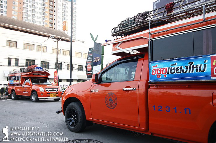
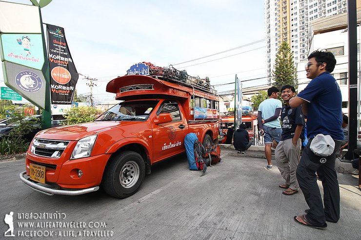
This trip was organized during the long weekend in early December. There were 20 members, including friends who had traveled together before and new friends we had just met. Traveling to Sai Yok is actually quite easy. There are buses from Bangkok to Ban Tha Ton, leaving from Mo Chit in the early evening and arriving in the morning. However, because our team was large and scattered, we decided to meet at the Chiang Mai Bus Terminal (Arcade) and then hire a songthaew to take us there. We used an orange songthaew, which is a local vehicle familiar with the route.


After gathering at the arcade, it was almost nine in the morning. We stopped by Mae Malai Market in Mae Taeng District to eat and buy supplies. After a while, we arrived at the meeting point with the Doi Wiang Pha National Park officials at the Shell gas station in Chai Prakan District. It was almost one in the afternoon.
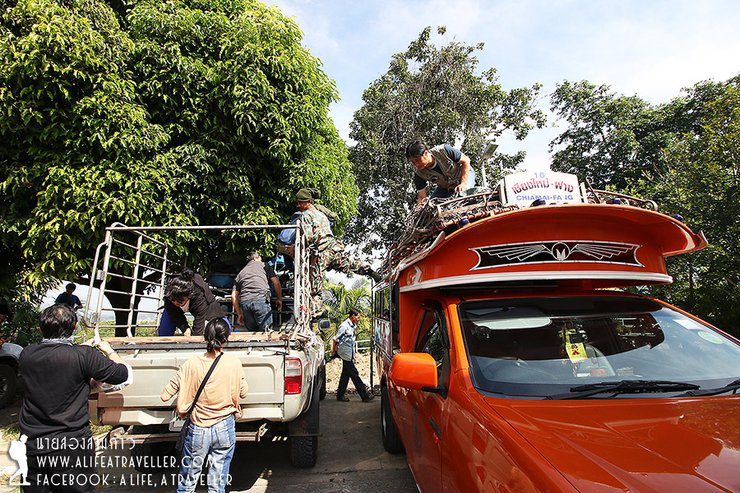
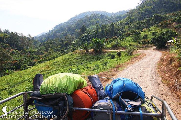
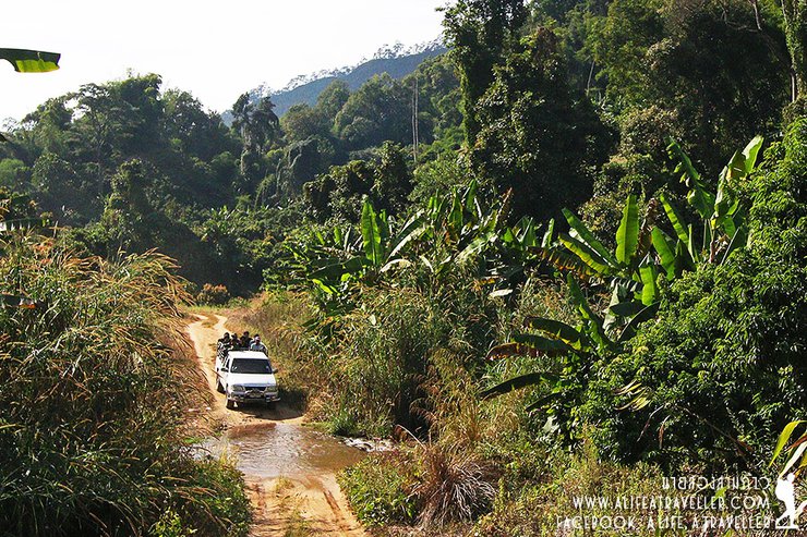
The team switched from a two-row vehicle to a four-wheel drive to continue their journey. Three officers led the way, and there were no porters. The vehicle took them to the ranger station at WPa.1 (head of the weir), from where they had to bounce along a 17-kilometer gravel road. The road was lined with coffee plantations, orange groves, and farmland, clearly indicating that the park was established after people had begun to clear land for cultivation.


From the ranger station, the car will drive slowly for almost two more hours before reaching Ban Doi Wiang, a Lahu village. This is the last point where you can use the restroom, change clothes, or organize your belongings. A short distance further, you will reach the starting point of the trail to the summit.
Hiking Trail Description
The trail ascends and descends via different routes. The ascent begins at Ban Doi Wiang, reaching an elevation of approximately 1,500 meters. The summit itself sits at 1,800 meters, requiring a relatively short climb. The descent takes place on the Mae Ta Luang side, covering a total distance of 12 kilometers.
The three-day, two-night trek involves a 4.5-kilometer hike to Camp 1, followed by another 4.5 kilometers to Camp 2, and finally a 3-kilometer trek to Mae Ta Luang. The trail is considered relatively easy with minimal inclines.


Glancing at the clock, it was 3:30 PM when we began our trek. We were divided into three groups: a lead group, a middle group, and a rear group. The officials kept count of the participants throughout the journey. This meticulous approach was necessary due to the initial section's susceptibility to getting lost. The abundance of clear岔路口s, stemming from the path's overlap with agricultural areas, posed a significant risk of straying into fields and orchards, potentially leading us astray.


The forest at Wiang Pha is relatively open. We walked up and down for about an hour without much difficulty, then crossed a stream. From here, the steepest section of the first day began. The officers called it "Neung Hop," which means "Huffing Hill." The name gives you a good idea of what it was like. It lived up to its name, and we were definitely huffing and puffing by the time we got to the top.


After a short climb, we reached the first campsite, known as Camp Son. We arrived during the flag-raising ceremony as the sky was changing colors, and the ghosts were drying their diapers. Unfortunately, there was no viewpoint near the campsite, so we could only capture this image.


Before it got too dark, we quickly set up camp. The spacious area was perfect for both hammocks and tents, allowing everyone to choose their preferred accommodation. We built a fire, cooked rice, and prepared dinner. The cool air, clear sky, and beautiful stars created a perfect atmosphere. It was truly an ideal camping spot.


(2)
The absence of a scenic viewpoint has its advantages, as it eliminates the need to wake up early (laughter…). And knowing that the walking distance is not far, we don't have to rush. Let's take a look at the atmosphere of the first camp in the morning.


The first camp has a stream 200 meters away, so there is no need to carry a lot of water. There are no toilets, so if you need to go to the bathroom, you will have to walk into the forest.

Note that this place is full of spiders, I don't know what kind they are, but they are quite beautiful. The venom is probably not very strong, but it's still a good idea to be careful.


We had ample time, so we ate and relaxed before finally packing up and setting off at 11:30 AM. The distance from the first camp to the second camp, or the summit of the mountain, was approximately 4.5 kilometers. The trail was not difficult, with mostly flat terrain and only a few steep sections. We arrived at the second camp after a leisurely two-hour walk.


Before reaching the summit, there is a pool of clean, drinkable water. The officers said that this pool will be available until around January. After that, we will have to fill it up from the first camp.

The view from the campsite on the top of the mountain was good and beautiful. Looking down, we could see the Mae Taeng Reservoir, which would be our way down. As usual, there were both tent and hammock areas. After we finished setting up camp, we cooked and ate.


The officer mentioned a sunset viewing point just 200 meters away, so I decided to take a look. The view was indeed stunning. On one side, Doi Luang Chiang Dao, the third highest mountain in Thailand, loomed in the distance. On the other side, Doi Pha Hom Pok, the second highest peak, stood closer. Next to Doi Pha Hom Pok was the Doi Ang Khang mountain range. From this spot, I could see three of Thailand's most famous mountains.


Around five in the evening, we all went to the sunset viewpoint. The atmosphere that day was beautiful, with mist floating in from the southern mountain range, adding to the scenery. We took photos with great pleasure, the sound of the shutters clicking merrily.


After the sun had set, a few friends and I stayed to photograph the stars and the Milky Way. During this time, there was still enough light to capture short exposures in the early evening. Although the stars were not clearly visible to the naked eye, we were still very satisfied with the results.


That night was another good time, eating rice, sitting around the campfire, happiness overflowing the mountain.


(3)
On the third day at Doi Wiang Pha, I was the first to wake up at five in the morning. I called everyone to see the morning atmosphere and hoped to see the sea of fog.
Note: The original text mentions that the viewpoint at Doi Wiang Pha does not offer beautiful sunrise views due to trees blocking the view. However, the sunset view from the same spot is described as stunning, offering panoramic vistas of both Doi Luang Chiang Dao and Doi Pha Hom Pok.
Here is the translated text:
It's important to note that the viewpoint at Doi Wiang Pha does not offer beautiful sunrise views due to the obstruction of trees. However, the sunset view from the same spot yesterday was truly magnificent. As mentioned, it offers breathtaking panoramic views of both Doi Luang Chiang Dao and Doi Pha Hom Pok, stretching far into the distance.
The Doi Luang Chiang Dao mountain range on this side is shrouded in mist that settles in the valleys. While not particularly spectacular, it is still quite pleasant.


The scenery at Doi Pha Hom Pok is arguably more beautiful than Doi Luang Chiang Dao. Doi Ang Khang is not far away. In my opinion, the sunrise at Doi Pha Hom Pok would have been more spectacular than at Doi Luang Chiang Dao. I say this with confidence, as I was at Doi Wiang Pha, which is located between the two mountains. (Haha...)


That day, although the fog was not spectacular, it lingered for a long time. As the morning progressed, it became even thicker and softer on both sides.


We took our time taking photos, as there was no need to rush. By the time we packed up and walked downstairs, it was already past ten o'clock. We snapped a few photos as a souvenir.

The 3-kilometer descent offered stunning views as we followed the mountain ridge, accompanied by refreshing white mist.


On the way down, I was in the last group. It was 12:20 by the time we reached the waterfall. The water level was a bit low, but it was still refreshing.


A short walk from the waterfall leads to the Mae Ta Lap Luang Watershed Management Unit, where four-wheel drive vehicles wait to pick up visitors. The surrounding landscape transitions back to open forest interspersed with agricultural areas used by local residents.
The return journey took almost two hours on a bumpy dirt road, arriving at the park headquarters. There was time to shower, pack up, and settle expenses with the park rangers. We had arranged for a shared taxi to pick us up there for the return trip to the arcade, before going our separate ways to our respective homes.

A two-night stay at Doi Wiang Pha, although not a well-known mountain, is undeniably impressive. The atmosphere is pleasant at both Camp One and Camp Two. The hike is not difficult, leaving ample time for other activities. You can relax and fully appreciate the natural beauty.
Before the trip, I had no idea where Doi Wiang Pha was. But on the way back, when I mentioned the name Doi Wiang Pha, I can tell you that I fell head over heels in love with it.
Summary of expenses, starting from Arcade, Chiang Mai
Estimated Travel Expenses
Transportation:
- Car rental (Chiang Mai - Chai Prakan): 7,200 THB (1,800 THB per trip, two cars)
- Park ranger guide fees: 3,600 THB (400 THB per person per day, three people)
- Park pickup truck (roundtrip): 5,000 THB (2,500 THB total for both trips, two cars)
Food:
- 3,700 THB
Total:
- 19,500 THB (divided among 20 people, approximately 975 THB per person)
Approximate Itinerary
Please note: This is a rough estimate and the actual itinerary may vary.
Day 1
- 9:00 AM: Depart from Chiang Mai
- 10:30 AM: Shop at Mae Malai Market in Mae Taeng District
- 1:00 PM: Arrive at the meeting point with officials in Chai Prakan District, transfer to a 4x4 vehicle
- 3:00 PM: Arrive at Ban Doi Wiang, the starting point for the hike
- 3:30 PM: Begin the hike
- 6:00 PM: Arrive at Camp 1
Day Two
11:30 AM: Depart from Camp One 1:30 PM: Arrive at Camp Two
Day Three
10:00 AM Depart from Camp Two
12:30 PM Arrive at the bottom of Mae Ta Lab Village, take a 4x4 vehicle
2:30 PM Arrive at the park headquarters, shower and freshen up
4:00 PM Change to a shared taxi, return to Chiang Mai
5:00 PM Stop for dinner in Chiang Dao District
7:30 PM Arrive at Arcade Bus Station, Chiang Mai, disperse and return home
A little information
Doi Wiang Pha National Park: Information for Hikers
Access: Doi Wiang Pha is open daily with no set closing date, except in cases of park closures due to safety concerns or other unforeseen circumstances.
Camping: Campsites one and two are suitable for both tent camping and hammock camping.
Facilities: There are no restrooms of any kind on the summit. Water sources are available near both campsites one and two, but water availability is not guaranteed. It is recommended to inquire with park officials for the latest information.
Connectivity: Mobile phone and internet signals are available from all major carriers on the summit, with signal strength varying depending on the time of day.
Wildlife: Leeches are not present along the trail. Encountering a leech is considered extremely unlucky.
Park Headquarters: The park headquarters offers accommodation options, including bungalows, a camping area, and restrooms. Visitors can stay overnight at the headquarters before or after their hike.
Entrance Fees: Currently, there are no entrance fees for Doi Wiang Pha National Park as the park is still in the preparation phase and the official announcement is pending.
Contact Information: Doi Wiang Pha National Park can be reached at 087-186-2118 or 0-5331-7535.
Follow my travel adventures on another channel: http://www.facebook.com/alifeatraveller
นายสองสามก้าว / A Life, A Traveller
Friday, October 4, 2024 3:04 PM