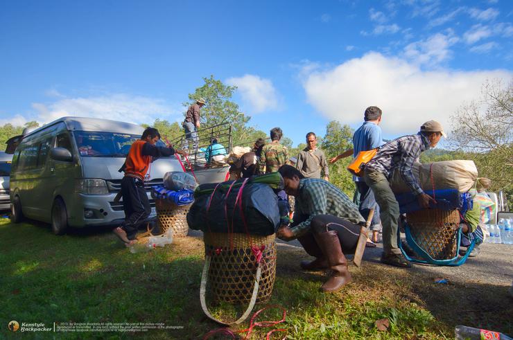
As the cold weather sets in, the feeling of "loneliness" follows closely behind. And every time I feel lonely, I find myself setting off on another journey. This trip, I joined a group from Bass Camp to climb another mountain in Chiang Rai province, located in Khun Jae National Park. The mountain we were going to climb was Doi Langka Noi - Langka Luang. My fellow travelers and I started our journey from Bangkok by van, heading towards Chiang Rai. From Chiang Mai province, we took Highway 118, the Chiang Mai-Chiang Rai route. At about kilometer 56, we found the Khun Jae National Park headquarters, located on the right side of the road, about 56 kilometers from Chiang Mai city. We contacted the officials to request permission to stay overnight at the park and asked them to arrange for porters in advance.
If you are interested in coming on your own, you can contact the Khun Jae National Park directly to make a reservation for a guide and porter at this address: Khun Jae National Park, Mae Chedi Mai Subdistrict, Wiang Pa Pao District, Chiang Rai 57260. Tel: 0 5316 3364, 08 4366 5213, 08 44892173 Fax: 0 5316 3364. From Chiang Mai, you can travel by air-conditioned bus or regular bus on the Chiang Mai-Doi Saket-Chiang Rai route from Chiang Mai Bus Terminal 2 (Arcade) or take a yellow songthaew on the Chiang Mai-Wiang Pa Pao-Tha Ruea Thanon Thai Wong route. Get off at kilometer 56.

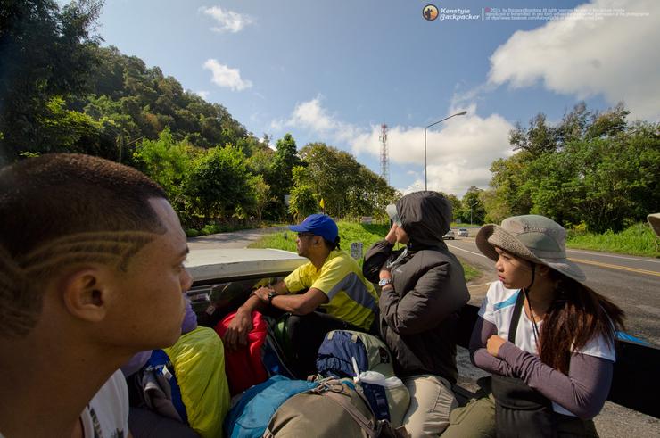
After arranging our belongings, we took a 4WD pickup truck to the main intersection at kilometer 27. We turned left and entered the starting point at Ban Mae Ton Luang. We went down to the radar station, without going back the same way. Alternatively, we could start walking at the radar station and go down to Ban Mae Ton Luang. The total walking distance is 17 kilometers, and it takes 3 days and 2 nights to complete the journey.


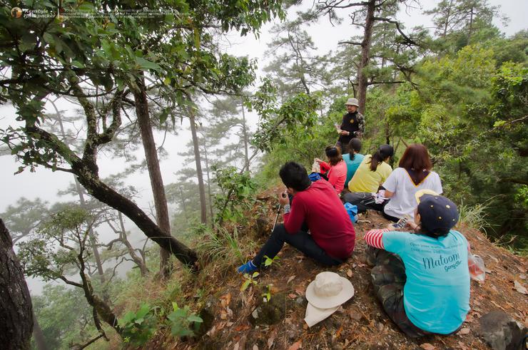
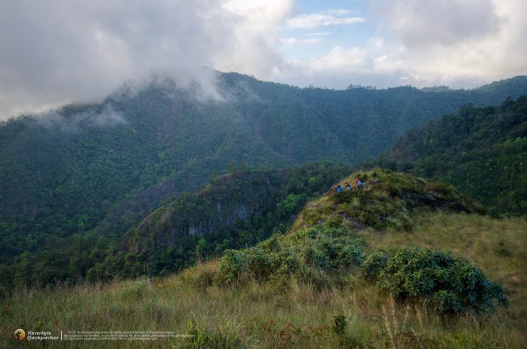
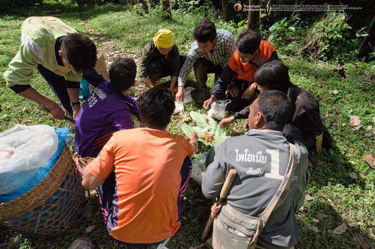
After the porters had finished their meal, we started our journey. The path from the villagers' coffee plantation was steep right from the start, giving us no time to warm up. We began to climb, walking along the ridge of Doi Jig Jong, the first mountain. This path was quite tiring for us, as we were still getting used to the altitude. We stopped to sit and eat lunch, enjoying the view of the mist that flowed continuously. The cool air hit our bodies intermittently. After finishing our first meal, we continued our journey until we reached the foot of Doi Lang Ka Noi. We were a little discouraged when we saw the porters, who looked like ants, climbing the steep mountain. We took a deep breath and continued walking, thinking to ourselves, "Who told you to come here? You came here on your own."


The mist floated gracefully around the mountain peaks, creating a truly refreshing atmosphere. The absence of sunlight made it the perfect opportunity to rest and wait for the others who were still making their way up.


After taking some photos, we continued climbing. The higher the path, the more thrilling it was, but it was not difficult to walk because there were rocks to hold on to and pull ourselves up.


Finally, we reached the top of Doi Lang Ka Noi, which is 1,600 meters above sea level. The surrounding scenery offers a panoramic view of the surrounding mountains. From the starting point, it took us about 3.30 hours to walk at a leisurely pace, covering a distance of 3 km on a steep path. We walked to the campsite, which is located 200 meters down to the left. There is a flat area large enough to set up camp and a spring in the valley behind the camp that provides enough water for cooking and washing. The porters who arrived earlier had already set up camp and were preparing dinner. After dropping off our belongings, we walked back to the top of the mountain to take in the panoramic view and wait for the sunset.


As we waited, we continued to take pictures. The sky was gradually being replaced by clouds and fog as the evening approached. The sky here is notorious for being rarely clear, as clouds and fog cover it almost all the time. Judging by the trend, it seemed unlikely that we would be able to see the sunset. However, we held onto the hope that the sky might clear up. Then, suddenly, the sunlight we had been waiting for shone through the clouds and fog, giving us a glimpse for no more than 5 minutes. The sound of camera shutters filled the air, then gradually faded away along with the last light of the day. We missed the opportunity to see the beautiful sunset we had hoped for. As we waited longer, the temperature around us dropped rapidly. Unable to withstand the cold December air on the mountaintop, we decided to return to the camp to find activities to drive away the cold.


Tonight is Father's Day. We all joined hands to offer blessings to His Majesty the King before going to bed. As for those who are still awake, they went to patrol and catch elephants on the mountaintop. Personally, I'm not very good at catching elephants, so I'm resting to gain strength to wake up and watch the sunrise tomorrow.


5:30 AM, I woke up to the sound of alarm clocks from tents here and there. The weather was so cold that I didn't want to leave the tent. I decided to grab my camera and walk out of the camp to the top of Langka Noi. It didn't take long because our camp was not far from the top. The sunrise began to paint the sky golden, revealing the light. Finally, the small egg yolk appeared.


We spent a long time admiring the scenery, taking photos from different angles, each of us searching for our own unique perspective to capture the beauty before us. The sea of mist was visible in the valley below, and this morning the mist was less dense than it had been the previous evening.


As the sun began to rise higher, the opposite side of the sky turned a deep blue. This morning there was little fog, making the sky very clear. We returned to the camp to have breakfast and prepare to continue our journey. The trail from Langka Noi camp to Langka Luang camp is about 6 kilometers long and takes about 4 hours to walk. We started walking from the camp down the back valley, climbing up to walk along the ridge. This area is full of two-leaved pine forests. There are signs pointing the way to Langka Luang at intervals, but you have to look carefully because the color of the signs sometimes blends in with the color of the forest. We lost some time feeling our way around the headwaters of the Arumi Rai waterfall for a while before we saw the sign to go up. We walked along the ridge, with not many ups and downs. Sometimes we had to wade through fields of cogongrass. Several people got cuts from the cogongrass, but no one complained, because everyone enjoys this kind of life. We walked on and on, resting when we were tired. We stopped at a hill before going down to Langka Luang camp. Looking back, we could see the peak of Langka Noi in the distance.


Camp Langka Luang is located in a valley at the foot of a mountain. The terrain is a mountainous rainforest with a water source not far away. We arrived at noon and set up camp. We had lunch and then sat and relaxed until around 4 pm before climbing to the top of Langka Luang.

At 4 pm, we left the camp and started our hike to the top of Langka Luang, which was about a kilometer away. As I walked up, I reached the flag hill on the left, which would cut down into the valley and then up to the top of Langka Luang. The weather was discouraging, and when I looked down into the valley, I couldn't see anything. The sky was overcast, just like yesterday, but today it seemed like it would be worse. I decided to wander around the flag hill looking for a place to take pictures instead of continuing on. However, the visibility didn't allow me to do much. I let the young people who were full of energy go ahead and chase their dreams first. I'll just go up tomorrow morning instead (an excuse for an old man, haha). I could only hear the voices of the young people from the top of Langka Luang over there, laughing and having fun. I couldn't resist... I decided to go down and help Sergeant Moo cook dinner at the bottom.


That night, I slept soundly, undisturbed. However, the tent on the other side, which was located near the Buddha statue, had a story to tell about an encounter during the night. But I won't go into it, because if we're not on the same wavelength, there's no chance of meeting it. Not everyone gets the chance to meet it, but this place is quite strong, as we've heard from many previous trips. Cutting back to the next morning, we started walking up to the peak again at 5 am. The distance of almost 1 kilometer was quite tiring because we walked up to the flag hill, then down into the valley, and then up to the top of Langka Luang. We each found our own spot, but we had to be careful because the spot with the view of the sunrise was about 100 meters before the highest point. The tall grass would block the view. If we walked into the tall grass, we had to be careful not to step on the air and float down into the abyss below without realizing it.


The sky began to brighten, revealing fluffy clouds floating in front of us. Looking back down the way we had come, the fog from the other side drifted across the valley from left to right, alternating with periods of clear and cloudy skies as the wind in the valley blew upwards, causing the fog to be quite hazy. While waiting for the weather to clear, we took photos on the highest peak of Doi Langka Luang, which is 2,031 meters above sea level, the fifth highest mountain in Thailand.


After seeing the weather conditions that morning, we decided to walk down. The path was wet with dew, making it slippery and causing several people to fall.

Upon arriving back at camp, we prepared breakfast and packed some for lunch on the trail. The final day's route would be quite long, around 10 kilometers, so we wouldn't have time to stop and cook. After packing up camp, we set off towards Pha Ngoam, another high peak that we had to cross.


We walked along the ridge of the mountain, one after another, until we reached a point where we could see the valley below and the surrounding landscape. We could also see Doi Pha Ngoam in the distance. We stopped to take some photos as a souvenir before continuing on our journey.


After that, we walked down the valley again and gradually climbed up the height of Doi Pha Ngoam. This mountain was very difficult and discouraging. No matter how much we walked, we couldn't reach the top. We walked and stopped because of the steepness. Although the walking path was easy and the height was only 1,700 meters, which was hundreds of meters lower than Langka Luang, it was much more tiring because it was so steep. The younger brother who had been there before told us that if we didn't climb up the mountain, there would be a shortcut along the cliff below, which was quite dangerous and went around the mountain. If we could get past Pha Ngoam, it would be easy. Actually, we were going to have lunch here, but the porter probably didn't understand Thai very well, so he walked ahead without waiting. Moreover, the one who walked ahead was the one who carried the food supplies. We had to ask another porter to chase after him and tell him to bring us lunch on the way. During this time, whoever had something to eat shared it with others. This is the spirit of fellow travelers. Even though we had never met before, the hardship helped us become one.


Descending from Pha Ngoam, following the advice of my younger brother who said that the next part would be easy. But wait, why is there a high mountain in front of us? The closer we got, the path led straight to that mountain. I asked the porter if we had to cross that mountain, and he said yes. That mountain is the highest and last mountain, called Doi San Yaw, and it really lives up to its name. Its height is comparable to Pha Ngoam, and it's just as tiring. Between Pha Ngoam and San Yaw, I barely touched my camera. I was really tired. On top of that, my unlucky leg stumbled on a rock and twisted a bit. Luckily, it wasn't too serious, and I could still walk. After getting off San Yaw, we encountered small hills, climbing up and down until we started to see the radar station's signal pole. We were relieved and hurried to get out, eager to return to the outside world as soon as possible. And finally, we made it. We walked through the radar station, a distance of 17 km from Mae Ton Luang village. We took a commemorative photo before heading to the unit to shower and freshen up before returning to Bangkok.

Thank you Travel Basscamp Thailand for organizing this trip.
Thank you Tanawoot Koiynon , Tanapat Klinphoo for providing some of the photos used in this review to make it more complete.
Thank you to the Matum gang for creating smiles and laughter.
Thank you to my fellow travelers for sharing this adventure with me.
-Thank you to my friends who came to watch and press like, press share to encourage me.
-For information exchange or inquiries about travel, please visit our Fanpage: Studdoy Hundred Stories
- Follow old articles here All travel trips

สตั๊ดดอย ร้อยเรื่องราว
Friday, September 27, 2024 10:03 AM