


Follow us on our travels #Travelers
www.facebook.com/konchoptieow
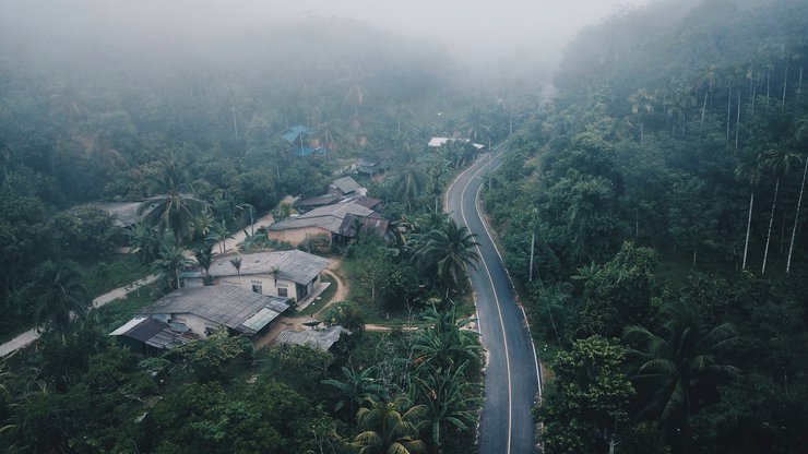
Nestled in a small community, hidden amidst the mountains, surrounded by lush forests, towering peaks, and diverse wildlife. Nourished by the pristine waters of the forest, a winding road leads to the heart of the community. As dawn breaks, a gentle mist envelops the village, accompanied by the tranquility and warm smiles of the locals.
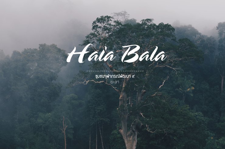
This is the Chulabhorn Development Community 9, nestled within the "Hala-Bala" forest in Thanto District, Yala Province. A haven of biodiversity at the southernmost tip of Thailand.
This trip would not have been possible without the support of the TAT's Social CSR Project.
This has given me and the #ฅนชอบเที่ยว team the opportunity to contribute to the promotion of community-based tourism.
To get to know each other better, Thailand has many tourist attractions in every corner of the country.
Today, I will take you on a tour of a small community in the "Hala Bala" forest, with overlapping mountain ranges.
The last remaining large, pristine rainforest in southern border provinces.
Essential Expenses
- Private car travel expenses - 3,000 baht (gas-powered car, so it's economical!)
- 3-day, 2-night tour package including accommodation - 1,950 baht per person (great value!)
- Includes 2 nights' accommodation
- Includes 6 meals
- Includes transportation within the community
- Includes a boat trip on the reservoir
- Unlimited fruit during your stay, eat until your sugar levels rise! 555+
Travel
- Private car From Bangkok >> Head to Yala >> To the community Total distance 1,200 km, approximately 18 hours. (Suitable for adventurous people, most economical, and also the most tiring 55+)
- Airplane Landing at Hat Yai Airport There are 3 options
- Rent a car From Hat Yai >> To the community Total distance 200 km, approximately 3-4 hours. (Suitable for those who want to relax, most convenient)
- Charter a van Similar to renting a car, suitable for large groups, good value, not tiring
- Charter a community car Pick-up and drop-off from Hat Yai to the community, approximately 2500 baht per trip (round trip 5000 baht)
- Bus Get off at Hat Yai Transport There are also 3 options
- Rent a car From Hat Yai >> To the community Total distance 200 km, approximately 3-4 hours. (Suitable for those who want to relax, most convenient
- Charter a van Similar to renting a car, suitable for large groups, good value, not tiring
- Charter a community car Pick-up and drop-off from Hat Yai, approximately 2500 baht per trip (round trip 5000 baht)
Check-in Points
- "Khao Hin Yok" Sea of Mist
- Boat Trip to Hala-Bala Forest
- Hala-Sa Waterfall Nature Trail
- Suspension Bridge Nature Trail
- Chulabhorn Development Community 9
- Klong Nam Sai Upstream Forest
- Historical Museum
Note: The original text is empty, so the translation is also empty.
Tourist Information
- Chulabhorn Development Community 9 is a community located in the heart of the Hala-Bala forest in Yala province. It is part of the same forest as Bala-Hala in Narathiwat province.
- Chulabhorn Development Community 9 is a community with a rich history, dating back to the Malayan Communist Party during World War II. There is a historical museum with authentic artifacts for tourists to explore.
- The 6 meals included in the trip are local dishes made with fresh ingredients from the community. Importantly, all food is free of harmful chemicals.
- There are many leeches in the Hala-Bala forest, as it is a humid rainforest. It is important to bring leech socks or repellent.
- For those who say Yala is dangerous, #Travelers, I can assure you that it is not at all.^^
Contact for accommodation and tour guide booking
- Local guide Thongthin Lingping 098-017-1846
- Page Chulabhorn 9 Development Community
- Book through website 1nightstaywithlocals
......
..........
Ready to go!! Friday evening at 5:00 p.m. after work, it's time to hit the road... Grab Google map and head to Yala.
"Chulabhorn Phatthana 9 Community" Oh my god, 18 hours, about 1200 kilometers, not including rest, lol.
I must say that this trip is the longest drive in our lives for all 4 of us..
..
And then at 7 a.m... We arrived at the first Check Point, which is Hat Yai.
Stop to wash our faces, brush our teeth, change clothes... and then continue on our journey >> Entering the 3 southern border provinces.
From Hat Yai, it takes almost 4 hours, about 200 kilometers, on the way from Hat Yai-Yala.
Before entering Bang Lang Dam, there are checkpoints at intervals with soldiers all the way... I think it's reassuring.
And when we reach the last 30 km before the entrance to the community, the road is winding and twisting all the way..
....
And then at 12.00 we arrived...
With a big set of food waiting to welcome us..
What are we waiting for? Let's eat, I'm hungry, lol.

After a delicious first meal in Yala, we felt our eyelids getting heavy...
But we couldn't sleep just yet! Our local guide, Ling Ping and Qi, had already started our Yala sightseeing program as soon as we arrived at the community. (In short, no rest for the weary!)
......
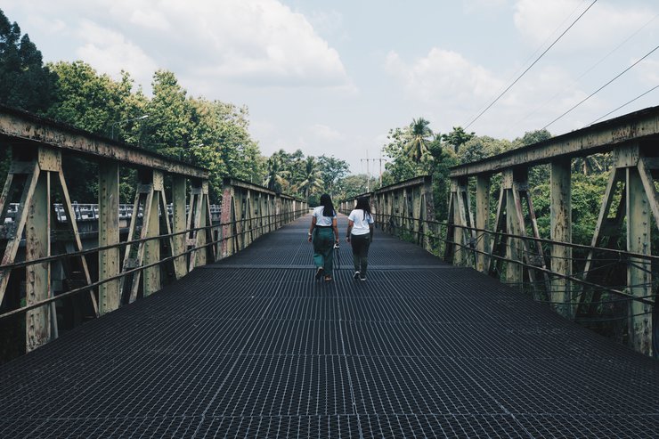
The first program of the trip was the suspension bridge and nature trail.
Enjoy the natural beauty along the stream. You can even swim here!
You can drive from the community and walk another 200 meters to reach the suspension bridge.
And here we are, the suspension bridge!


Cold, clear water


After visiting the suspension bridge, it was time to check into our accommodation. There were many fruit trees behind our accommodation, including rambutan, langsat, and mangosteen. We were very lucky to be able to pick and eat fresh fruit straight from the trees. We ate so much fruit that we got a sugar rush!

The accommodation is of a good standard. At night, the air is cool, and a single fan is sufficient to keep you comfortable.

......
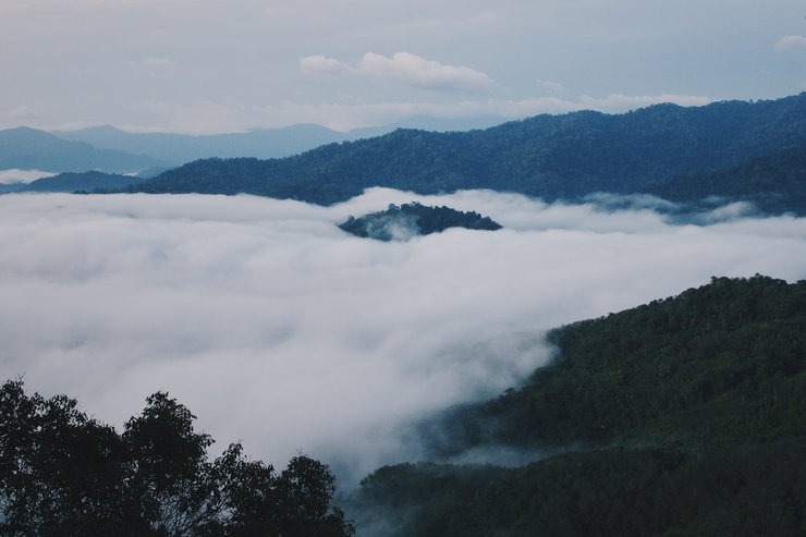
A new day has arrived, and it's time to witness the sea of mist. From our accommodation, we took a 20-minute car ride
followed by a 30-minute hike. Let me tell you, the climb was quite steep! 55+
And here it is... one of the highlights of this trip: #KhaoHinYokSeaOfMistViewpoint

The humid rainforest is characterized by daily fog.
(Guide Lingping remarked, "It's so annoying, I see it every day, I'm tired of it." There's no need to get excited, haha.)


Around 8 am, the fog began to dissipate, signaling the time to descend the mountain.

Here is a high-angle view of the sea of mist at Khao Hin Yok viewpoint.

This rock is the origin of the name "Khao Hin Yok".
If we stand and rock behind the rock,
the rock will rock noticeably. If you have the opportunity to come here, don't forget to try rocking the rock! ^^

After enjoying the stunning sea of mist, it's time to head back to the accommodation for breakfast.
On the way back, there's a cool photo spot, so let's stop by for a quick break.

1 2 3 Smile

After recharging, it's time to go to the next check-in point.
#Halasah Waterfall Nature Trail
Along the way, there will be green trees, small and large, all the way..

Oh, I forgot to mention that this forest is a rainforest. Because it is very fertile,
one of the most abundant things in the Hala-Bala forest is... #cute snails, very cute (high-pitched voice) 555+

From the parking lot, walk approximately 300-400 meters along the path.

We have arrived at Halaszah Waterfall. The water level is low at the moment, making it easy to climb to the top.

Near the Halasz waterfall, there is a community deer farm.

After lunch, it's time to cruise to the Hala-Bala Wildlife Sanctuary.


From the boat landing, it's a 600-meter walk.
And here is the #GiantDipterocarpTree of the "Hala-Bala" forest, it's huge!


The final stop is the #headwaters, which the locals call #clearwater stream.
Water from the Hala-Bala forest flows into the Bang Lang Dam.

In July, the water level is not yet high, allowing you to dip your feet in the cool water.

The morning atmosphere was shrouded in mist, and this morning was the last day of the trip.


On our way back, 30 km from the community, we stopped by #Bang Lang Dam.
This dam is the starting point of the Pattani River.

Concluding our historical bridge tour, the Hongsanguan Bridge stands as a testament to the past. Spanning the Pattani River, this bridge was constructed by the Japanese military during World War II, approximately in the year 1945.

And lastly, we would like to express our sincere gratitude to the TAT and the Social Organization for guiding us, travel enthusiasts, to discover one of Thailand's most captivating destinations, a hidden gem that many may not be familiar with.
We are thankful for the opportunity to connect with so many wonderful people and experience the warm hospitality of the Chulabhorn Phatthana 9 community.
Our appreciation extends to the delicious meals served throughout our three-day, two-night journey, with breakfast, lunch, and dinner always arriving on time.
Join us on our future adventures!
Follow us on:
- Facebook: www.facebook.com/konchoptieow
- Instagram: www.instagram.com/konchoptieow
Supported by:
[Insert logo or name of sponsor]


ฅนชอบเที่ยว
Wednesday, February 26, 2025 6:57 PM