


This review focuses solely on the actual route I took alone, with photos included for easy understanding.
This is a motorcycle journey to Ban Pa Bong Piang from Chiang Mai city. The journey starts with a train ride from Bangkok to Chiang Mai.
This review focuses on the actual route encountered, without using any stand-ins.
It is expected that the following will be explained in a comprehensive and clear manner.
The author compares their experience to working for the Department of Highways, as they have captured images of the route. (Note that some parts have been omitted for clarity.)
It would be very beneficial for everyone.
Another option, if you don't want to rent a car for 700 baht and want to travel to Ban Pa Bong Pieng by motorbike, is to do so.
Though it may be a bit of a detour, it's a relaxing ride. However, it's important to note that you need to be a skilled and experienced motorcycle rider, and you need to be physically fit. This route is especially suitable for thrill-seekers, as it's full of challenging sections that will test your skills.
This trip was brutal because as soon as we got off the train from Chiang Mai Railway Station, we rented a motorbike from the station and rode straight to Mae Chaem.
We are not looking to rent a car in Jom Thong or Mae Chaem, as we plan to continue our journey to other destinations beyond Mae Chaem. We will be exploring Chiang Mai in a circular route.
I will describe the images in the order they appear. Please follow along on Google Maps.
We will provide an approximate distance in kilometers. Travel time will vary depending on the driver's speed. Some drivers may drive faster or slower, while we tend to drive slower, around 30-40 km/h, and we often stop to take photos along the way.

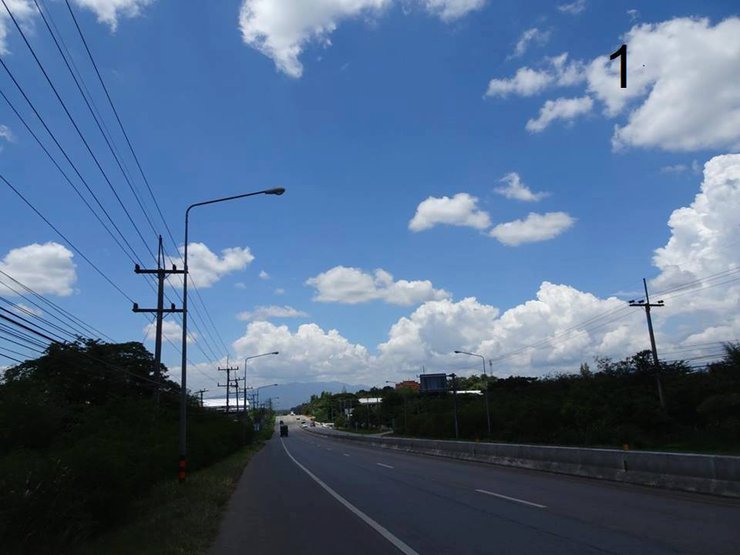
1. Travel on Highway 108 from Chiang Mai city, driving slowly and enjoying the scenery for 2 hours.
This road is easy to drive on, but it can get quite sunny.
I have driven to Doi Inthanon before, so I am familiar with the road.

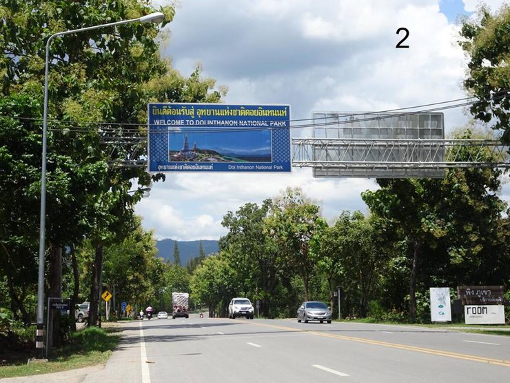
2. Take Highway 1009 towards Doi Inthanon National Park (but we will not enter the park).

3. The scenery along Highway 1009 is characterized by fresh air, lush greenery, and a refreshing atmosphere.

4. Upon entering the park, there are two checkpoints. After passing through the checkpoints, the distance is approximately 80 kilometers.
At the first checkpoint, inform the officer that you are heading to Mae Chaem. They will not charge you the park entrance fee. At the second checkpoint, repeat the same statement.
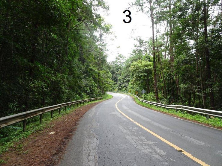
After passing the second checkpoint, you will reach a fork in the road. To reach Mae Pan Waterfall, turn left onto Highway 1192 towards Mae Chaem District.

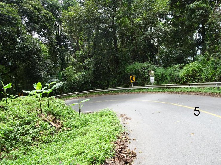
The trail is approximately 13 kilometers long and features winding, uphill and downhill sections. Notably, there are numerous sharp turns, occurring every 50-100 meters.

6. Locals may forget to honk their horns, but please respect the traffic rules when you see this sign. There are many sharp curves, so honk your horn throughout the entire route. There are many blind spots and oncoming large vehicles (such as pickup trucks or sedans). The smell of burning brakes fills the air.

7. At this sign, the path to Huai Sai Luang Waterfall turns right. It's only 2 kilometers away (but the road is rough), and you'll reach Ban Pa Bong Piang. Go down a bit, and you'll meet the staff. If you have your own car, there's parking available. You can wait here and call your accommodation to pick you up, as many people have reviewed. Regular motorcycles can go this way, but it requires a local who is familiar with the road, such as the hill tribe people who travel in and out frequently. We secretly asked if the locals can use this motorcycle route regularly, and they said yes. However, we are not locals, and we rented a car, so we won't risk it. At this junction, turn left.

From Highway 1192, continue driving until you connect with Highway 1088, heading towards Mae Chaem District Office, approximately 16 kilometers. The road is smooth and paved, safe, with minimal uphill and downhill sections. The scenery along the way offers some picturesque spots for photo opportunities.

9. Seeing the sign "1 km to Mae Chaem" filled me with immense relief. I couldn't believe I had driven all this way. Haha!

10. Continue driving straight until you reach a roundabout near the Mae Chaem Subdistrict Administrative Organization (SAO). Do not turn anywhere, or you might get lost like us (haha!). (Turning the wrong way can change your life, it's a long story.) At the roundabout, go straight. If you are confused, ask for directions from locals. Find your way to the Mae Chaem District Office. Look for this sign:

11. At the Mae Chaem District Office, there is a three-way intersection. If you look to the right, you will see a 7-Eleven. If you need to buy anything, stop there first because there are no shops after that. Once you see the 7-Eleven, continue straight ahead for a long distance.

12. Continue driving straight until you reach Baan Baan Tung Yao. This road is still Highway 1088, but it may be difficult to find on Google Maps. You can put away your phone now, as you won't need the map anymore. Don't worry, it's a mandatory road, and you just need to follow the signs we've shown you in the pictures. It's super easy to get there.

The distance from Mae Chaem District Office to the entrance of Ban Tung Yao School is approximately 8 kilometers. Look for a small sign on the right-hand side. Do not pass it.

Turn right and you will see Wat Tung Yao first. When you see the temple, turn left immediately.

15. Continue for approximately 1-2 kilometers until you see the sign for Ban Mae Ming. Proceed straight ahead.

16. The road will start to get muddy, as we went during the rainy season, but it wasn't too bad, still drivable.

17. Continue driving until you see a small sign on the right-hand side indicating the direction to the Mae Awm Watershed Management Unit. Proceed straight without turning. (Note: There may be some confusion about the order of Mae Ming and Mae Awm, but it doesn't matter as the road is a mandatory route.)

18. The signs will gradually become smaller. Observe the right-hand side carefully. You will see a sign for Intanon Wittaya School. Turn there. The distances between each point are not far apart, some are 1 km, some are 2 km. We are searching for the way. There are villagers riding motorcycles passing by. It seems deserted, but it is not. The road is narrow.

19. This is probably the most muddy section since I started driving. I just drove down, it wasn't deep (but I saw the villagers driving, so I followed them, haha). Honestly, if it's not necessary, I wouldn't recommend four-wheel drive vehicles on this road. The road is damaged, there are many potholes, and it will cause the road to sink further due to the weight. And the locals, who mostly drive motorcycles, have to use the road with many potholes that cannot be repaired. Wow, this trip made me realize the importance of the villagers. I thought I was the district chief of Mae Chaem.

20. Encountering this wooden bridge brings us closer to reality.

21. Continue straight ahead. When you see the sign for Ban Pa Teng, turn left. Don't get lost in the village.

The road was bumpy and narrow in some places, but it was manageable. As we drove along, we stopped to take pictures of the scenery along the way. The views were similar to what you see in the picture.

23. By the time they reached Ban Pa Bong Piang, it was already late afternoon, and the sun was about to set.

24. A sunset that looks good no matter what camera you use, even without filters.

25. Although it was tiring, I am proud to have learned more about the routes in Chiang Mai. I got lost a few times and had to ask for directions, but I was able to communicate with the locals. If you want to drive there alone, it's not difficult, but it can be a bit challenging. It's a long drive from Chiang Mai city, but it's an experience you'll never forget.

Follow our journey on our page. We will be traveling alone.
The sentence is already in English and does not require translation.

Boe_Stories
Wednesday, February 26, 2025 9:12 PM