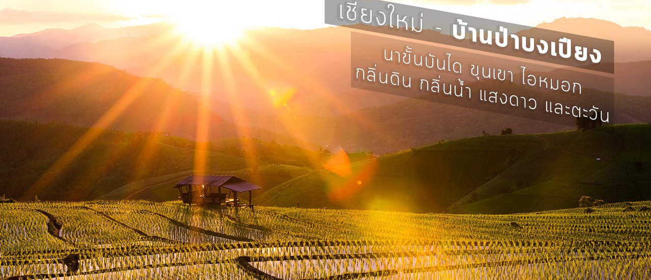
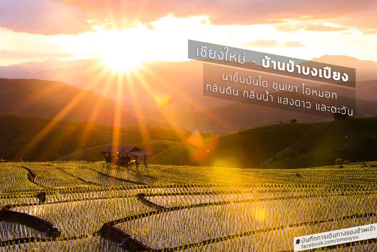
Reflecting the sky, the rice fields meet the horizon. Terraced rice fields of Pa Bong Piang.

Table of Contents
From origin to destination.
*** Lush across provinces
*** Distance is no barrier when hearts are connected.
*** Explore and recommend 3 routes to Ban Pa Bong Piang. Which route is the best?
*** Home of the Pa Bong Piang?
When is the best time to visit Pa Bong Piang?
*** Preparation and Precautions for Visiting Pa Bong Piang Forest

The lush greenery of the rainy season, even the tips of the rice stalks in the morning, can bring joy if we choose to see it that way.
From origin to destination
Ignorance and Inexperience: A Catalyst for Curiosity
The absence of knowledge and the lack of experience, rather than instilling fear in some individuals, can ignite a thirst for knowledge once anxieties are shed. This yearning is further amplified when anticipation builds, creating an intense desire to encounter the unknown.
"I long to witness the breathtaking beauty of rice terraces during the rainy season. I yearn to see them with my own eyes, from the flooded fields to the verdant green and the golden hues of harvest. I want to experience it all."
Inadvertently, I made a promise to myself. It may seem excessive, but I truly yearn to experience these things firsthand. I am well aware of nature's allure, its verdant beauty, and the profound impact of travel. It is therefore understandable that those who embrace travel wholeheartedly and have a long-awaited trip planned would share my anticipation.

After two falls, the YAMAHA M-Slaz was back on the road in Ban Pa Bong Piang. The rider explored other routes and took photos in nearby villages in the morning.
I continue to use my YAMAHA M-Slaz 150 cc motorcycle for my travels, but I will no longer be using side bags. Even though I will be carrying a tent and sleeping bag, my new backpack can accommodate all of my belongings. I will separate the lens and notebook bag and place it in the rear box, while the camera bag will be slung over my shoulder while riding. This will allow me to stop and take pictures along the way, as I often come across scenic views that I enjoy.
Crossing Provinces in Comfort
The itinerary was left blank at first. Monday was chosen, as it is on almost every trip, because it is the day when the tourist attractions are likely to be the most peaceful, with the fewest tourists. This gives me the opportunity to connect with nature and the local people more.
The plan was to leave at midnight on July 25, 2016, but the actual departure time was 1:00 AM. However, this was not a problem, as the scheduled time was a buffer for any delays, such as slow progress, roadside photo stops, rain avoidance, getting lost, or traffic jams that could prevent further travel. Therefore, the destination would definitely be reached before nightfall. It was estimated that if there were no problems and not too many roadside photo stops, the destination would be reached around 1:00 PM.

The overall route from Bangkok to Ban Pa Bong Piang in Chiang Mai, which was planned without much knowledge.
From Bangkok, the route leads through Bang Khae to Nonthaburi, Pathum Thani, Ayutthaya, Ang Thong, Sing Buri, Chai Nat, Nakhon Sawan, Kamphaeng Phet, Tak, Lampang, Lamphun, and enters Chiang Mai via Chom Thong district. Exiting Chom Thong, the route follows Highway 1192 before leaving the highway and following a village road whose condition is unknown to reach Ban Pa Bong Piang.
I am aware that the road leading to Pa Bong Piang Village is not in good condition. However, I have heard that several sections have been improved, although not all of them. Despite this, I was overconfident and believed that I could handle the situation. I thought that even if I encountered problems, it would be a memorable experience.
Despite the heavy downpour, I managed to park my motorcycle and cover my camera bag with a rain cover. However, the heavy rain soaked my backpack, which was packed on the passenger seat. Surprisingly, the backpack's water resistance held up well, although the contents felt slightly damp. On the return trip to Bangkok, a light drizzle caused some internal dampness, suggesting that the backpack might not be completely waterproof in prolonged light rain.
The heavy rain in Bang Khae gradually subsided but did not stop completely. It was almost time to enter Nakhon Sawan when the rain finally stopped. I had been riding in the rain the whole time, but I was not worried about getting sick because the clothes I was wearing covered my body quite well. However, I might get sick if I continued to let my body get cold like this. So, I stopped my motorcycle at a gas station in Chai Nat, near Mano Rom district, before 6:00 AM. I took off my arm sleeves because they made me feel even more damp. I didn't change my clothes, which were still wet, but my body warmed up a lot because I wasn't exposed to the wind from riding the motorcycle.

The morning view is truly breathtaking. I would love to come back here again, perhaps to capture the sunrise from different angles in this area. (Coordinates: https://goo.gl/maps/kso1gWx4WU52)
After a sufficiently long rest, I began to observe my surroundings and noticed that the sun was about to rise. The sky in front of the gas station was a beautiful shade of purple. However, I was not quite prepared and by the time I rushed to the front of the station, the light had already begun to turn orange. I tried to capture the scene while lamenting the missed opportunity, as the view in front was also quite beautiful. I could only take a picture from the gas station towards the east, where the rice fields were located on the other side of the road. I then decided to quickly go back to collect my belongings and drove the car out to find a spot to take pictures in front of the gas station. However, I could not find a good enough spot, so I just walked across the street and stood in the middle of the road to take pictures. I figured that if I kept looking for a place to turn around, I would not make it in time. After taking pictures there, I continued on my journey. In total, I had rested for almost an hour.
Follow me on my page for more pictures and detailed information about recommended places to visit. My photography and travel recommendations page https://www.facebook.com/omeoyou/
Long journeys seem short when the heart accepts them.

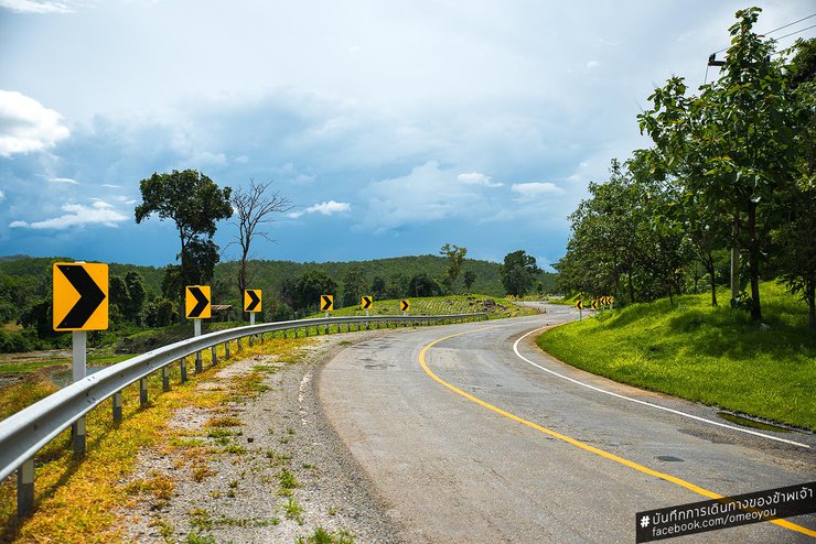
The warning signs to follow the winding path made me chuckle a little, as they seemed to be placed one after another as far as the eye could see along this stretch of road.
From Bangkok to Chiang Mai: A Motorcycle Journey Through Picturesque Landscapes and Challenging Roads
The journey from Bangkok to Chiang Mai, spanning nearly 750 kilometers, is not a short one for a motorcycle ride. My trip, exceeding the planned duration due to numerous photo stops and challenging road conditions, particularly before reaching the village of Pa Bong Piang, highlighted the importance of careful route planning.
To assist future travelers, I have explored three potential routes and will provide detailed descriptions, along with a Google My Map, to facilitate informed decision-making.
For a comprehensive overview of the routes and their respective challenges and rewards, please refer to the following link: http://bit.ly/ป่าบงเปียง.
I feel like it wasn't as long as I thought, but as far as I can remember, it might be because the long night drive made time seem to fly by. Because I was just driving, and if I was driving during the day, I think my mind would be wandering and making it feel slower.
As the sky brightens, the closer I drive to the mountains and forests, the more at ease I feel. The beautiful roads and the views I've never seen before make me feel happy and content.

The mountains in this area are dotted with cornfields. It's hard to tell if the cornfield here is tall or if the hut next to it is short. It looks like a stream of cornfields flowing down the slope and flooding the hut.
The owner of the accommodation in Ban Pa Bong Piang called before I reached Chiang Mai and suggested that I take the Mae Chaem route instead of blindly following the GPS from Bangkok, as the road would be difficult. However, our communication was not very clear, and I only understood that I needed to go through Mae Chaem district. I set a waypoint on my GPS for the Mae Chaem district center, thinking that I could then set another waypoint for Ban Pa Bong Piang once I arrived. It seemed like a good plan, but I didn't realize that it would be no different from coming up through Chom Thong if I didn't know the correct route and just let the GPS guide me.

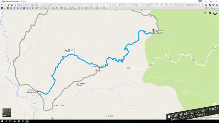
From the tourist service center to Ban Pa Bong Piang, the GPS route will take us to the most difficult route. As for the recommended route, please scroll down to the bottom of this article for recommendations.
While the GPS might not be entirely accurate, the route it suggests is indeed a valid access point. Moreover, the presence of a tourist information center at the starting point in Mae Chaem further reinforces the notion that I am on the right track. This suggests that this route is likely a recommended path for tourists.
No, not at all. The exit from the main road to the village connecting road through the tourist service center (coordinates https://goo.gl/maps/KrqcKccFdVw) will still lead you to the last road before reaching the Pa Bong Piang village, which is the worst road among the 3 routes I have surveyed. And I don't know, so I went there.
The initial section of the trail from the tourist service center is in good condition, especially for a mountain path. It is made of undamaged concrete, albeit narrow and occasionally steep, but not difficult to navigate. However, the final 2-3 kilometers before reaching Paba Bong Piang village are more challenging.

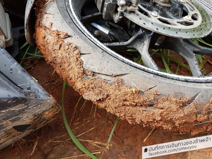
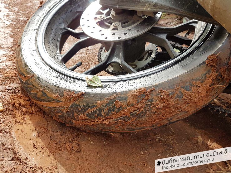
Front wheel

The rear wheels were in a different condition, as they had been skidding and sliding all the way.
The path is steep, muddy, and full of deep holes. Some of the holes are not just ruts in the dirt, but round stones ranging in size from a human head to a pinky finger. This means that if you fall in with tires that are not specifically designed for off-road use, and they get clogged with mud, it will be very difficult to get out.

"Certainly, I fell asleep. However, getting up this time is a bit difficult, as the handlebars are stuck in the ground."

Forced to take a break, leaving the car behind for a while to give it a rest. It's already covered over 20,000 kilometers. With that in mind, I shouldered my large backpack and continued on foot, contacting accommodation along the way. I figured I couldn't be far now, so finding a place to stay shouldn't be too difficult.
I decided to call the owner of the accommodation for help and packed my big backpack on the pillion seat and continued on foot, leaving my black M-Slaz lying on its side after the long journey. The tires were also burnt out after I fell into a ditch while trying to climb up.
After walking uphill for a while, I met the owner of the accommodation riding a motorbike with his friend, a local villager, to help me. It took three people to lift the car back onto its wheels, as two people could barely lift it. The other friend helped me push the back of the car, while the owner of the accommodation took my backpack and followed me on his motorbike.
I later learned that the person who pushed my car had been running alongside it to keep it steady, and had injured their ankle in the process. They didn't mention it to anyone, and I planned to ask them about it when we met at the guesthouse. However, I saw them walk away and assumed they were going to wash their foot. I didn't see them again, as they were not a resident of the guesthouse but an acquaintance of the owner who had come down to help me.
The villagers here are very familiar with tourists. When my car broke down again near the village, the villagers saw and heard the unfamiliar sound of the car, and many of them rushed out to help me. They even seemed to be competing with each other to help. The next day, I heard the sound of a car stuck in the mud. It was a tourist's car, and it was stuck for hours. The villagers rushed around to find tools to help, and finally they were able to get it out.

The road in front of the accommodation where I will have to park nearby (I am staying at Maechi Pho, there will be no specific parking space, but there are no cars running around here. However, if it is at Baan Rabeang Na, Pa Bong Piang, there will be an area within the surrounding area for private parking.)
Explore and recommend 3 routes to Baan Pa Bong Piang, which route is the best?
From the beginning, I intended to explore as many routes as possible to create a travel map to Ban Pa Bong Piang to share with others. In fact, I had photos of the different points along the way, but I don't know where they've all gone -_-' It's a shame, so I only have the travel map I made. You can see it at this link: http://bit.ly/ป่าบงเปียง If you have any questions about any of the points, you can ask me on the 'My Travel Log' page (http://facebook.com/omeoyou).
Route 1 - Through the Mae Pan Waterfall Protection Unit (recommended route, which is also the main route used by villagers)
Route 2 - Through Wat Tung Yao
Route 3 - Through the Bang Mae Chaem Municipal Office (the worst route, suitable for those who want to ride off-road)
If you are driving yourself, Route 1 is the recommended route. However, if you want to see the views of other villages, you can take Route 2. The road is not as bad as Route 3, which is suitable for off-road vehicles and those who enjoy extreme off-roading. However, Route 2 is still quite challenging, especially before reaching the Pa Bong Piang village. Only attempt this route if you are confident in your driving skills.
The rough terrain section is not particularly long, only about 2-4 kilometers. However, the rough terrain on Route 1 is located on flat ground with stagnant water and slippery mud, making it the most convenient rough terrain section.
If you prefer to drive yourself and avoid the off-road journey, you can park your car at the Mae Pan Waterfall Protection Unit (coordinates: https://goo.gl/maps/iri55t8B7yu). Then, call the homeowner (it's advisable to book in advance as they may be difficult to reach) and arrange for a pickup truck to transport you for a fee of 700 baht, including entry and exit. Don't worry about your car parked at the unit; lock it securely, and there shouldn't be any problems. The villagers have already spoken with the unit officials to allow tourists to park their vehicles there.

If you are coming from Chom Thong, you will see this type of road. We will follow Highway 1192 and come to a junction that leads to the Mae Pan Waterfall Protection Unit ( https://goo.gl/maps/iri55t8B7yu). At this point, you can use GPS to set the destination to the Protection Unit. No problem, you won't get lost.

After leaving the main road, the road becomes a concrete road, approximately 5 meters wide. The road begins to slope upwards, so please drive carefully. The road is covered in green moss, which can make it slippery.

Before reaching the entrance to the ranger station, there is a bridge crossing a stream.

As you continue riding, you will come to a fork in the road. The right path leads to Mae Pan Waterfall, while the left path leads to Pa Bong Piang Forest. From this point, the paved road ends, but it is not far to Pa Bong Piang Village.

You will encounter a fork in the road near the bridge over another stream. The left fork leads to Pha Samran Waterfall, but we will turn right and cross the bridge.

The road is made of dirt and has some large puddles in certain sections. Be careful of getting stuck, and motorcycles may skid. However, the road is not steep, so there is no danger.

We have arrived at the entrance of Pa Bong Piang village. If you turn left, you will enter the village and reach Baan Ra Biang Na and Pa Bong Piang. If you turn right, you will go to Ma Chi Po, which is only a few meters away from both places.
Pa Bong Piang Village?
A small Karen village, Ban Pa Bong Piang, is located in Mae Chaem district, Chiang Mai province, behind Doi Inthanon. The name Pa Bong Piang derives from the area's characteristics as a plain (the word "piang" means plain) that was once a forest of bamboo species called "bong." However, the current seven households in the village practice farming, rice cultivation, buffalo raising (other villages raise cows), and operate homestays for tourists during the rainy season.

Looking down from the paddy field, one can see a sparse line of accommodations above. In the paddy field itself, there are only two or three accommodations.
Only 5 out of 7 families in Ban Pa Bong Piang operate homestays. However, there are 2 additional homestays run by villagers from nearby villages who own land in Ban Pa Bong Piang. In total, there are 7 homestays available, each with 2-4 houses, without overcrowding the area.
The first homestay here is called 'Machipo', which means 'farmer' in the local language (contact number 081-020-1691). It was built four years ago by a young man who studied in the city and returned to open a homestay after graduation to accommodate tourists who began to discover the rice terraces of Ban Pa Bong Piang five years ago.

The accommodations come in various shapes and sizes. Most can comfortably sleep up to three people, while some smaller units are designed for two guests.
Subsequently, the villagers began to operate homestays, bringing the total to seven. The seventh and most recent homestay is owned by a young man from the nearby village of Tin Pha, who named his accommodation 'Baan Rabeang Na, Pa Bong Piang' (contact number 080-794-6883). After graduating with a degree in agriculture, he returned to develop and build a homestay in Pa Bong Piang with the concept of enhancing the homestay experience for tourists. This includes planting vegetables that tourists can pick and use to cook their own meals, as well as a project to grow plants and flowers that will allow tourists to participate in tree care activities.
The homestay accommodations here have been agreed upon by the villagers, so the prices and services are similar. The price is the same, which is 500 baht per night, including breakfast and dinner. The shuttle service from the homestay to the Mae Pan Waterfall Protection Unit is 700 baht round trip and can accommodate approximately 6 people. For additional small services, you should inquire about what else is available. For example, at Baan Rabeang Na Pa Bong Piang, there are vegetables that you can pick to cook your own meals, and there is a large surrounding area where you can have a picnic or even barbecue if you bring your own stove, as there is plenty of space.

During the rainy season, the rice planting season, which begins in late July, we will see that most of the rice fields here have been planted with rice seedlings. However, there will be some rice fields that are waiting to be planted with rice seedlings. This makes this time a great time to visit. In addition to seeing the rice seedlings in the rice fields that are full of water reflecting the light and reflecting the clouds, you will also see the way of life of the farmers who come to help plant the rice.
Accommodation includes beds, mosquito nets, blankets, and pillows. At night, candles or electric lamps are used for lighting, as electricity has not yet reached this village (the only one in the area without electricity).
Prior to the recent surge in tourism, the Bong Piang forest was primarily visited by niche groups of tourists for the past 20-30 years. These tourists, who were typically off-road and 4x4 enthusiasts, were drawn to the challenging terrain and rugged roads. While they may have enjoyed the experience, the local residents were not particularly fond of the damage caused to the roads. However, they tolerated the situation as a means of coexistence.
The road conditions have significantly improved, and various services are now available to assist tourists. While not entirely convenient, the area retains its unique charm. The terraced rice fields are the main attraction, offering vast, continuous landscapes. On some mornings, mist or even a sea of fog can be observed. Additionally, exploring the terraced rice fields in other villages is possible, each offering its own distinct beauty.

This place does not have crowded accommodations or is so dense that it spoils the beauty of the scenery.
When is the best time to visit Pa Bong Piang Forest?
I have planned to visit the rice fields during three distinct periods this year:
Rice Planting Season (July-August): During this time, farmers transplant rice seedlings into flooded fields, creating a mesmerizing reflection of clouds in the water.
Green Rice Season (September onwards): This period is characterized by lush, verdant rice fields, offering a picturesque landscape.
Golden Rice Harvest Season (November): As the rice ripens, the fields transform into a golden spectacle, showcasing the beauty of the harvest.
Although there are no tourists visiting the rice fields during the hot season, the high altitude keeps the air cool and offers expansive views. The absence of electricity makes it an ideal location for stargazing, with no light pollution to interfere.

The second morning of my stay here (July 26, 2016), there was a sea of fog in front of the tail, extending outwards. There was no hazy fog covering the body.
Preparation and Precautions for Visiting Pa Bong Piang Forest
- Sun hat, rainproof, but mainly sunproof, because it can already block out light rain. It's okay if it gets a little wet.
- Warm clothes, socks, long pants, and gloves if you are very sensitive to cold. Although the accommodation will provide blankets, it is recommended to bring some if you are easily chilled.

After a night's rest, I began taking photos at 6:00 AM. I rode my motorbike, exploring Route 2 and searching for photo opportunities in nearby villages.
- Shoes that dry easily are essential, as walking along the paddy field ridges can be slippery, making it easy to fall into the rice paddy (during my three-day, two-night stay, I witnessed 5-6 people falling into the paddy field, with some even falling in twice).
- Avoid stepping on the rice paddy unnecessarily, especially if you haven't planted or transplanted rice seedlings. This can disrupt the rhythm of rice planting for farmers, as the soil will become compacted and uneven after being stepped on. Additionally, stepping on the ground near newly planted seedlings can cause them to float, as their roots haven't had time to take hold properly. This can damage the seedlings, especially since many of the rice paddies in that area belong to people from nearby villages, not just those from Pa Bong Piang village.

In the mornings, we can see villagers walking around or doing agricultural activities. Most villagers will smile at us if we smile at them, and some will even greet us.

It is unclear whether the roof seen is a house or just a farm shed. However, this villager has to walk up to the top, which is quite steep and a considerable distance, to reach the road above. If it were a house, they would probably have to walk up and down very often. It is more likely that it is just a farm shed.
- Mosquito repellent and antihistamine for insect bites, prepared.
- Prepare your regular medication. There is no doctor there. There is a medical facility only when you reach the Mae Chaem city center, even though it is only about 10 kilometers away.

The roads in other villages are made of concrete and are in relatively good condition, with only a few bad sections here and there. This is in stark contrast to the roads in the Pa Bong Piang area, even though it is only 2-3 kilometers away.

The sample route is damaged, but it is still not difficult to drive. It is not a scary off-road route. Local people mainly use motorcycles, except when there are many people or carrying goods, they will use pickup trucks. As for cars, I didn't see any.
- Flashlights and floodlights. If you prioritize, prioritize floodlights, as we probably won't be walking around much outside at night. However, wide-beam floodlights will make it easier for us to do activities at night.
- Cooking and lighting fires on the property require prior permission from the owner. This is due to past incidents of fires caused by tourists. However, at the Baan Rai Bieng Na Homestay in Pa Bong Piang, guests are allowed to light fires and have barbecues, but they must inform the owner beforehand.

Throughout the journey, we witnessed crops, vegetables, and rice fields, some of which were located directly adjacent to the road.

The terraced rice fields of Baan Tin Pha are ideal for capturing the morning light, especially on days when mist hangs over the fields. The sunlight grazes the rice paddies in patches, creating a visually pleasing effect. The air is cool, even in the sun, but I still seek shade, as the heat is already starting to get to me.
- Drinking and utility water is supplied by a mountain waterworks system. The water is delivered through pipes and filtered, making it clean and safe for use.
- No restaurants or grocery stores. Be prepared before arriving in the village.
- It is advisable to bring two power banks if you are a heavy phone user, as there are no power outlets available.
- Both True and AIS mobile signals are accessible, but I am unsure about DTAC as I do not have a mobile phone or SIM card to use. If DTAC is willing to provide me with one, I would be happy to test it.

On July 26, 2016, in the Pa Bong Piang forest, there were still rice fields waiting to be planted. In the afternoon, I stopped by to take pictures of the villagers who came to help with the rice planting. I heard from Nong Batti, the owner of the homestay, Baan Rabien Na Pa Bong Piang, that the rice field, although located in the Pa Bong Piang village area, belongs to a person from the Tin Pha village.

Although it is the rainy season, not every day is gloomy. It is important to check the weather forecast carefully. However, accommodation is often fully booked, requiring advance reservations. As a result, it often comes down to luck to see the sky in such a beautiful shade of blue.
- No Wi-Fi service is available. There is no electricity yet.
- Dry food and snacks, bought in case the food is not to your liking, so you don't have to get upset because you are hungry.

Even though it is the rainy season, the vast sky sometimes experiences rain even when the horizon remains a clear azure.

The three of them huddled together, talking and shielding themselves from the rain with a plastic sheet, even though they were already soaked. Meanwhile, the others were busy planting rice nearby. It's almost as if they were in a Facebook group, chatting away in their own little bubble.
- Cameras and tripods are essential, but it is advisable to use a plastic bag to protect the camera and lens. Tie the bag securely and place it in another bag. If you accidentally drop it in a rice paddy, you can quickly lift it above the water to prevent damage from getting wet.
A friendly smile and an open heart await you in this refreshing, enjoyable, and atmospheric place. The food is plentiful and satisfying, and while life here may not be luxurious, it's certainly not unbearable. The inconveniences are part of the charm, offering a unique experience. Capture stunning photos of the mist, the coolness, the lush greenery, and the peaceful ambiance to share with your friends. The warmth of the people, the delicious food, the comfortable sleep, and the ease of photography will leave you feeling nothing but contentment.

I stayed for 3 days and 2 nights. I was lucky enough to see the sea of mist, the mist covering my body, the clear sky, the cool light, and even the Milky Way in one visit.

Although the image is blurry due to camera malfunction, it still shows how clear the stars are at Ban Pa Bong Piang. This is because there is no electricity available, and the only light source is the electric lamps brought by tourists. Even at 9 pm, the stars are clearly visible.
The friendships I forged here, both with the villagers who helped me push my car up the hill, even though they themselves were injured and bleeding quite a bit, without saying a word to me (I only found out later when they ran away), and with Nong Bati, a student who returned to develop his hometown, were invaluable. We talked for a long time, and I learned about his determination to improve the tourism facilities at his accommodation.

Above, clouds; below, mist. We are above the water's surface, sitting on a pavilion built for tourists to relax. There's no need to think too much. Just looking at it, you know how comfortable it is to sit here.

Walking along the paddy field bund can be tricky at times. I've seen people fall into the paddy field, both by sliding down with just their legs and by falling straight down. In the picture, the mother is trying to help her daughter who is shocked after sliding down into the paddy field, while the father is running to help both of them as quickly as possible, even though he ends up sliding down himself.
Despite the lack of electricity and the bumpy roads, the charm of this place is undeniable. Once you open your mind, you'll realize it's not that difficult to adapt. Even if you're accustomed to a luxurious lifestyle, you can still visit by arranging for a local to pick you up. After a 15-minute bumpy ride, you'll reach your destination. The starry sky, the fresh air, the delicious food, the warm hospitality, the opportunity to chat with locals, and the chance to witness rice farmers planting their crops – all of these experiences are worth the journey. Compared to the usual office environment, this change of scenery is truly invaluable.

The fleeting glimpse of the last light, lasting no more than 10 minutes, was a stroke of luck that allowed us to witness the twilight glow of this place.
We can gain and lose, but what matters is whether the gains are worthwhile and how much we are willing to embrace them. More importantly, how well and sustainably can we maintain them? Remember to strive for appropriate development as well.
The Images Below
The images below were all taken in or around the home of "Nong Bati," who runs a homestay called "Baan Rabeang Na Pa Bong Piang." Although I did not stay with him, he invited me up to his house to chat and allowed me to take photos for several hours. (Contact number: 080-794-6883)

From the veranda of the house on stilts in Ban Rabeang Na, Pa Bong Piang, you can see the pine cones that Nong Bati has hung up. He said that if they are exposed to the sun, they will close up, but if they are exposed to rain, they will open up. Or am I getting it mixed up?

From Baan Rabeang Na Homestay in Pa Bong Piang, you can see another angle of the Pa Bong Piang rice terraces. This is because it is a high angle looking into the rice fields.

Looking out into the distance, one can see cornfields and other crops on the hillsides. Behind the hills, there must be a village at the foot of the cliff.

The vegetables that Nong Bati planted are available for tourists to pick and eat. They can also be used to cook food as desired.

The balcony in front of the bedroom, in the evening, the light shines in, it looks so chill.

There are many vegetables that we can pick and eat, not just one or two.

The younger brother told me that Muslims also like to stay at his house because they can pick vegetables to cook themselves without worrying about the containers, as they will bring their own.

The sign of the accommodation there, although I did not stay there, but I feel that the staff are well-intentioned and have ideas for developing the area. It has only recently opened, so not many people know about it. I would like to help as much as I can.
เดินทางตามฝัน
Friday, September 27, 2024 10:22 AM

