Wandering aimlessly in the city of sticky rice
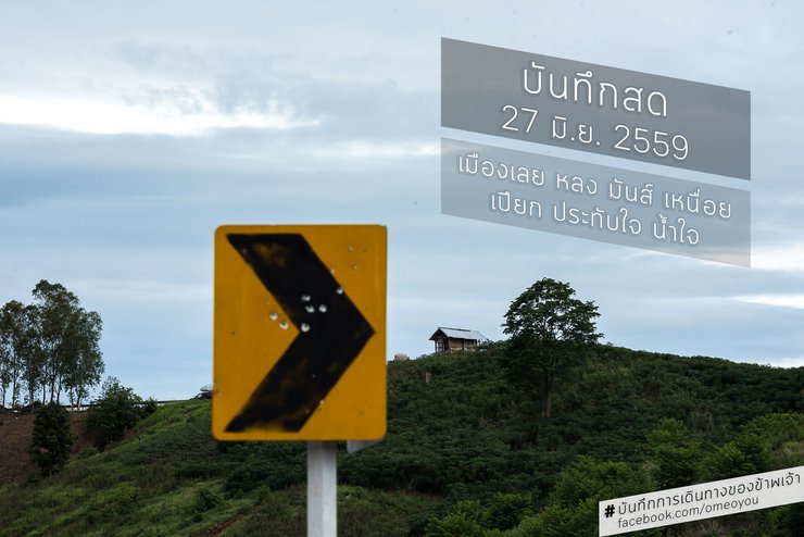
[Live recording of my journey]
Follow other works from Page https://facebook.com/omeoyou

From the live recording on June 25-26, 2016 (http://pantip.com/topic/35316607), you can see that on the 27th, I had to go out and find places to take pictures myself because my friends were busy. However, we ended up meeting in the afternoon when my friends finished their errands and returned to the accommodation. Then we went to Phu Bo Bid (a viewpoint on Phu Ho or known as Fuji of Loei). In the early morning, I decided to leave the accommodation at almost 4 or 5 am to try out the Sky Road or find some angles in the early morning.

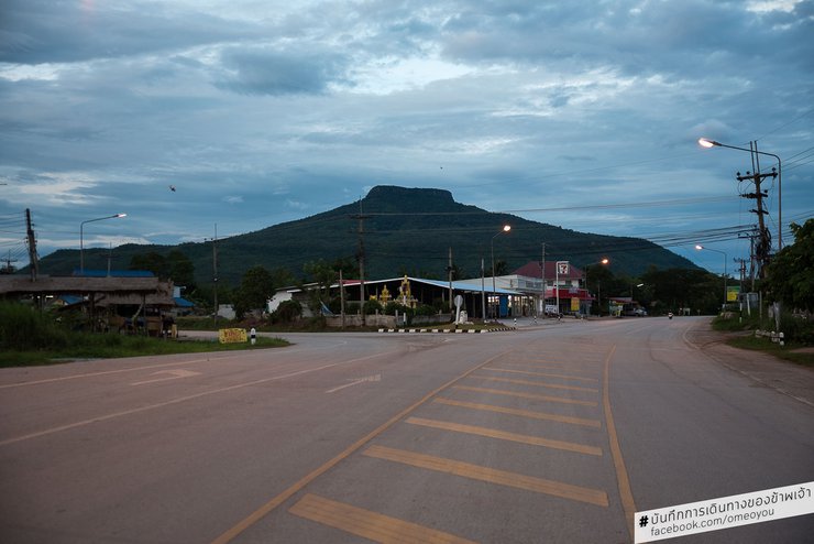
From one perspective in Phu Luang district, Phu Ho has a 7-Eleven.
Coordinates https://goo.gl/maps/qKifobLyJCH2
On the 26th night, I woke up at 4:20 am to take some photos, as I had seen that the sun rises early. However, when I walked out of the house, it was still very dark. So I did some chores and left the house around 5:00 am, using Google Maps to navigate to the elevated road (Highway 2016). But when I turned out of my alley, I made a wrong turn. I was surprised because Google Maps kept saying to go south, but I tried riding for a while to see if Google Maps would recalculate the route.

This area boasts extensive rubber plantations. My friend, whom I stayed with previously, informed me that the land was primarily used for cassava cultivation. However, over time, the majority of the land has been converted to rubber production.
The provided text is empty. There is nothing to translate.
The sentence translates to:
"Yes, it did set a new route, but based on my experience and the terrain, I had a nagging feeling that it might lead me into the forest or a rubber plantation. It wasn't even dawn yet, and I was a bit nervous. And sure enough, it took me on a dirt road through a rubber plantation that spanned several acres. It took a long time to get back to the paved road, which significantly delayed my next photo opportunity."

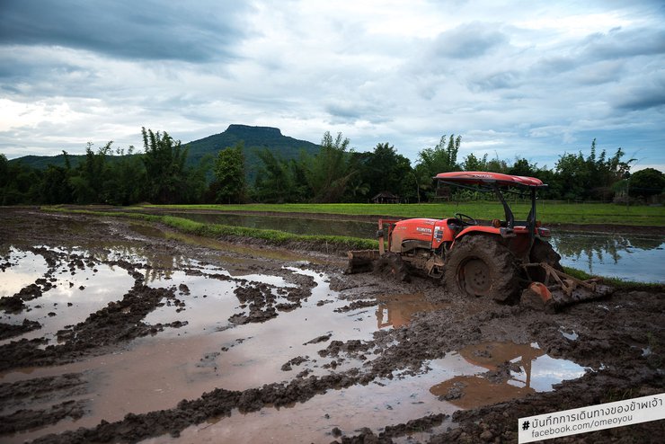
The rice planting season has arrived, and glutinous rice is more commonly consumed here than non-glutinous rice. The fields here are likely to be planted with glutinous rice.
The sky began to brighten, revealing villagers waiting to offer food to monks. Some had already started walking through the rice fields. I searched for a spot to take photos in the fields that had not yet been planted with rice. However, I couldn't find an angle I particularly liked. I wanted a shot with reflections of the newly planted rice fields, or the morning sun on the water, or the evening light. But I didn't have much time left. I wanted to catch the mist on the Skywalk, but I didn't think it was likely because the mountain was mostly bare. Still, I held onto hope, remembering how I could almost always see mist and clouds covering the peak of Phu Luang from my friend's house during the rainy season.

Don't worry, I'll lead the way.
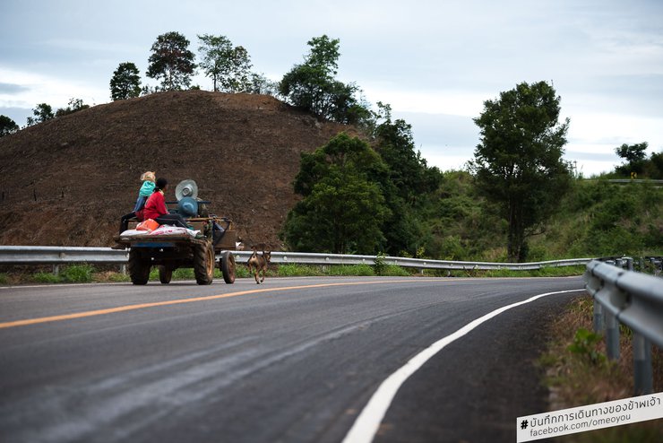
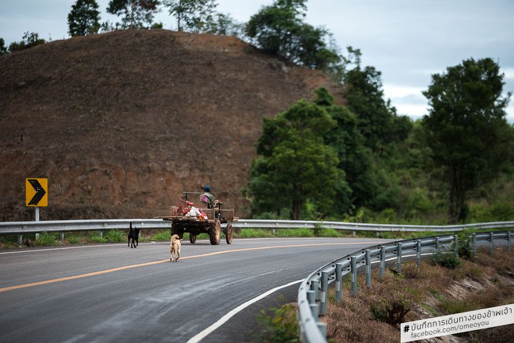
As the sky brightened, I saw many villagers driving their "e-taek" (a type of small tractor) out of their homes. They were heading to their fields, rice paddies, and orchards, which were often located outside the village. Many of them had farms and gardens near the "Bald Mountain," which I would be passing by on the "Sky Road."

Uncle, where are you going? I'll go with you.
Some passengers were in groups, perhaps relatives. Some had dogs sitting in front, running ahead or following behind. One friendly uncle saw me standing there, looking up and down, dressed strangely, holding a camera but not taking any pictures, and asked me (sometimes you have to wait for the right moment for the car to enter the scene), "I'm waiting to take a picture, uncle," I replied after the uncle asked me in a local accent, which made me have to ask him what he said several times before, until the uncle started to wonder if I was messing with him. But in the end, the uncle smiled and said, "Feel free to do so."

Two friendly uncles greeted me, a stranger.
When people here realize we are from the central region, from Bangkok, they will try to change their vocabulary and accent to make it easier for us to understand. (This is generally the case in all regions, for example, when I went to the south, it was the same.)
I find it immensely enjoyable to listen to the local people with their unique accents. The people of Loei province are said to have the sweetest Isaan accent. Sometimes I don't understand what they're saying, but I still enjoy listening. It makes me feel good and I often find myself smiling when I hear them talking animatedly.

The mist I saw drifted to the right and dissipated. That's Highway 2016. I rushed from this corner to that spot as quickly as possible.
Coordinates https://goo.gl/maps/kzZqT1AqAaH2
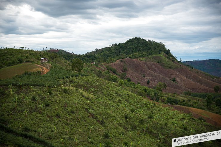
The photograph captured a ribbon of mist hovering above a forested mountain peak amidst barren hills. I quickly snapped a few shots of the scene, noticing cars passing by in the distance, heading towards the misty area. This confirmed my suspicion that it was part of the Skywalk shrouded in fog. The prospect of capturing stunning shots of the Skywalk amidst the mist filled me with anticipation.

This is the spot where the mist was billowing, but I arrived too late. It had already completely dissipated. What a pity.
Coordinates: https://goo.gl/maps/8Wc9yb8wo3n
The mist was not dense and dissipated as I passed the tree line and entered the barren mountain. I rode to the spot, but I was disappointed because the mist had already cleared. It was probably because it was getting late, and the humidity and temperature were no longer suitable for fog formation. However, I will return another day.

Highway 2016, a popular route for travelers entering Loei city or traveling from Loei to Bangkok.
Coordinates https://goo.gl/maps/8fbvYMvXexR2
Riding back to my accommodation, I noticed that Phu Luang was not far ahead. There must be a road leading close to the foot of the mountain. Before reaching the last bend, I turned towards my friend's house where I was staying. I saw a small alley, but it pointed towards the mountain. I quickly turned around and entered the alley to take a look.
The provided text is empty. There is nothing to translate.
After a short ride, I left the community behind. I saw some meditation centers and forest monasteries, but I didn't pay much attention to them. I was considering whether to try riding to the foot of the mountain, if possible, or to the very end of the road.

Forest Protection Unit in Nam Thob Village
Coordinates: https://goo.gl/maps/VKK2HP2wFGS2
The path I was riding on came to an end, and a sign in front read "Nam Thob Forest Protection Unit." I talked to my friend, who told me that the village, which was not far from the foot of the mountain, had paths leading to various protection units. This particular unit was located next to the Nam Thob stream, hence the name "Nam Thob Forest Protection Unit." Another village was located next to the Nam Chan stream, and its protection unit was named accordingly. Some protection units might have interesting features, while others might not. The Nam Thob unit, for example, was situated by the peaceful Nam Thob stream, which was not very large but offered a sense of tranquility. The final destination was a cave temple. From what I could see, there was only one monk present, and the atmosphere was very serene. A few elderly villagers, two to four in number, were sitting and talking. I also noticed a large number of butterflies.

The entrance to Wat Tham Phutthamon is located inside.
I did not visit the Nam Jun Protection Unit. Local friends told me that there is a fairly high waterfall there, but it is probably not a good place to take pictures because it is overgrown. It is not developed as a tourist destination, but there are sometimes groups of students who go up to the waterfall.

The temple sits atop a hill with a cave and a stupa. I did not climb up, as I was preoccupied with finding a way down to the Huai Nam Tab stream located nearby.
Coordinates: https://goo.gl/maps/wMAtaydSVw42

The temple is incredibly serene and peaceful. Entering it brings a sense of immediate tranquility.
We arrived at our accommodation around 10:00 AM and waited for our friends before setting off again. Our destination this time was not Phu Bo Bid as planned the night before, but instead the 'Phu Luang Wildlife Sanctuary' (coordinates https://goo.gl/maps/iRgzKg87NJQ2). Although we knew that the authorities were closing the sanctuary for restoration during this period, we secretly hoped that they might allow us to go up and see, admire, and take pictures. However, we had already prepared ourselves for the possibility that they might not, and that it would not be a problem. We understood, and simply wanted to try.
https://goo.gl/maps/6FNuaSzxz952
The provided text is empty. There is nothing to translate.
Every day since I've been here, I've seen the peak of Phu Luang. It's almost always covered in clouds and mist, and the very top is a series of layered rocks, with the uppermost part seemingly flat. The green is so vibrant that I decided to attempt the journey, even though I knew the chances of getting in weren't very high.
Old review thread about tourist attractions
Live recording June 25-26, 2016 [First visit to Loei, impressed by the sky road] (http://pantip.com/topic/35316607)
Giant Water Lilies, Sunken Sun, Shallow Sea, Water Buffalo, Migratory Birds, Lamphu Tree - Thale Noi - Phatthalung (http://pantip.com/topic/34977668)
Wooden Bridge, a Relaxing Way of Life for the Mon People - Mon Bridge - Sangkhla Buri - Kanchanaburi (http://pantip.com/topic/34907371)
Admire the sea of mist and experience the warm hospitality at Khao Pha Nen Thung - Khao Pha Nen Thung - Kaeng Krachan National Park - Phetchaburi (http://pantip.com/topic/34582338)
Bang Phra Reservoir: A Cyclist's Paradise in Search of a Riding Partner - Bang Phra Reservoir - Chonburi (http://pantip.com/topic/35208447)
This page showcases my photography of recommended travel destinations. You can find more information on my Facebook page: https://www.facebook.com/omeoyou/

Today, we encountered rain on our journey to find kindness. The rain had been threatening since we left home, but it wasn't a concern. We were aware of the possibility and had prepared ourselves mentally. We drove along the main road up to Phu Ruea. The newly constructed road has reduced the severity of the treacherous S-curve at the "100 Corpses Curve," making it easier to navigate. However, it remains a dangerous stretch. We stopped to take in the view from this point, oblivious to the rain clouds that were stealthily creeping in. We were caught off guard because we couldn't see the clouds hiding behind the peak ahead.

My friend and I found a way to climb up and take pictures at the 100-corpse curve, which has now been diverted to a new road, making it less dangerous. (This picture is of my friend.)
Coordinates: https://goo.gl/maps/asd93SWnHAt
After taking photos at the viewpoint, I continued riding for less than 5 minutes when the rain started to pour and became increasingly heavy. I noticed a house standing out along the main road to Phu Ruea, as I hadn't seen any other houses on my way. Without hesitation, I stopped by and shouted to the first person I saw walking by, asking if I could take shelter from the rain.

100 corpses from the corner curve
Coordinates: https://goo.gl/maps/asd93SWnHAt
Before I could finish my question, the stranger pointed for us to park before I could even ask. He smiled gently and welcomed us. I parked the car, took out the items, and found that there were three people sitting under this roof.

The relentless rain began shortly after passing the infamous "100 Corpses Curve." Despite the solitude, a lone house stood open, welcoming weary travelers who encountered trouble along their journey.
Coordinates https://goo.gl/maps/1Y7Gc53xAJr
The homeowner, who also owns the pottery workshop behind the house, and his brother, a construction contractor from Rayong who recently returned to his hometown in Loei after two months, were drinking together. Another brother, who often jokes around, was speaking in a local dialect that I couldn't understand. He seemed shy and was talking to his friends in their local dialect, occasionally laughing. I noticed that the bottle of white liquor was almost empty. Without taking his eyes off the bottle, the homeowner grabbed it and poured some into a glass, offering it to us. We told him we didn't know how to drink it, and he immediately drank it himself.

Let's eat together.
The food was freshly prepared and still warm, having just been brought out to welcome the rain-soaked guests. Despite having recently eaten, we couldn't refuse, wanting to show our appreciation for the host's genuine hospitality.

The sculptures of the Buddha and various animals, created by the homeowner who sheltered us from the rain and his two assistants who are currently away, are truly magnificent. It's hard to believe how beautiful they are.
The contractor took me to see the view behind his house. He talked for a while about how beautiful the view was, saying that other people didn't see it because they wouldn't stop by unless they had to. However, this house often welcomes unexpected guests, such as people with flat tires, burnt brakes, or who are caught in the rain. Some people even had to leave their cars there for two days while waiting for a tow truck. The contractor even rode his motorcycle to take them to the transportation center in town. He refused to take money, but he joked that he wouldn't mind some liquor. I think he was serious, though. Haha.

A rare view of the shelter from behind, captured by few.
Coordinates: https://goo.gl/maps/sus4QRdJExr

Another corner of the small house in the big forest
It was time for the farewell party. I told my colleagues that I would stop by to say hello or visit when I passed by. I rode my motorbike up the winding, steep road, passing through community after community until I reached my destination: Phu Luang Wildlife Sanctuary.
The rain has stopped, we must continue our journey.

How disappointed were the travelers?
We had already used up our energy when we arrived at the destination. The officer clearly stated that we could not climb Phu Luang. We knew full well that the chances of this happening were high. We looked at each other and wondered what to do next, as we hadn't planned much. The mine officer sat in the middle of our meeting, pointing to the next destination that our friend proudly presented.

The wildlife sanctuary officer is using a map on their phone to locate Mount Phoke.
Coordinates https://goo.gl/maps/dLvfrA91WWB2

Thrilled to have stumbled upon a hidden gem, 'Phu Pok', a name unknown to most except locals. With only a handful of villages nearby, we estimate less than 1,000 people worldwide are familiar with this place. Excitement surged as the park ranger pointed us towards the coordinates. A quick glance revealed a sight even more breathtaking than his description. Towering cliffs, steep slopes, and a paragliding launch point – the topographic map painted a picture of pure exhilaration.

The ascent to Phu Pok is actually steeper than it appears in the pictures. The photos don't capture the full height.
Coordinates: https://goo.gl/maps/6NSsCZkeZbQ2
My heart sank. "Oh, great," I thought, "I'm definitely going to be exhausted today." It had just rained, and my friend had told me that the trail was packed red clay. "Well," I thought to myself, "it can't be that bad. I've ridden some pretty rough trails with this trusty motorcycle. I've never even dropped the bike before. I should be fine." But I couldn't help but feel a little apprehensive. What my friend considered "normal" might be a whole different story for me.

Damn, the path changed my life. My pure and innocent motorcycle riding life, with a history of never falling no matter how rough or slippery the road, has to end here. It's like I lost my innocence today. When we reached the starting point, we looked at each other and wondered if this was the right way. It didn't look like a path up a mountain, but rather a path to a farmer's field. It was both steep and eroded by water.
Shouting to the villagers who were farming there, "Which way to Phu Pok, brother?" Everyone there pointed up the path that was in such a bad state. Without hesitation, I told my younger brother that I would ride ahead and then walk up after him to get past this point, in order to test it out.
The terrain was more challenging than anticipated. The soil and rocks were sturdy, despite the presence of deep ravines carved by flowing water. "Let's try riding tandem," I suggested, but my words were swallowed after two minutes of riding. The path ahead was covered in mud from recent rainfall, and the deep gullies and potholes made it nearly impossible to ride. My companion dismounted and walked, finding it faster than riding.

Climbing higher and higher, getting tired.
My car frequently gets stuck in the mud, requiring assistance to push it out. Controlling the vehicle is nearly impossible due to the slippery mud. I am familiar with the mud's slipperiness, having experienced it firsthand on previous days.
I'd be glad to translate the provided text, but I'll need more information to ensure an accurate and contextually appropriate translation.
Please provide the following details:
- Source language: The language in which the text is currently written.
- Target language: The language you want the text translated into.
- Context: Any relevant information about the text's purpose, audience, or field of study. This will help me tailor the translation to your specific needs.
Once I have this information, I can proceed with the translation.
Here are some additional tips for providing effective translation instructions:
- Be clear and concise: State your request in a straightforward manner, avoiding ambiguity.
- Provide examples: If possible, include examples of similar texts or translations that you find satisfactory.
- Set a deadline: If you have a specific deadline for the translation, please let me know.
I'm committed to providing high-quality translations that meet your expectations. Please feel free to provide any additional information that you think would be helpful.
The absence of gravity on a flat surface would not pose a problem, as we would only be subject to the car's inertia. However, on a slope, gravity would cause the car to decelerate and slide down. This sliding would not follow the controlled path of the wheels, even if they were angled, due to the slippery mud. The ruts would make it difficult to find a foothold in many places, leaving my legs dangling above the ground. I would attempt to lean towards the downhill side, but if successful, we would become stuck. If unsuccessful, the consequences would be dire.

The road is so slippery that I fell off my bike. I've fallen twice already, and I'm not sure if the road ahead will be any better. I think I'll park my bike here and walk the rest of the way.
"The loud thud wasn't a fart, but the sound of my motorcycle falling over due to the aforementioned circumstances. As someone who has recently lost their motorcycle virginity, I was understandably concerned. We managed to lift the M-Slaz, which weighs almost 140 kilograms, back onto its wheels despite the steep and slippery terrain. Getting it back up seemed manageable, but the question remained: how would I get it out of there? Deep down, I knew I might have to resort to the plan I was hoping to avoid. But before that, I decided to give it another try."
“Bang” for the second time, damn it. I'm not a virgin anymore. This is more like gang rape. The road ahead is no different from the one behind. It's much faster to go up. The plan in my heart was awakened to tell my younger brother next to me, who didn't agree very much. I said, "You don't know if you don't drive yourself." I've been to Phu Lom Lo and Phu Khieo with this younger brother before. That time, my younger brother was a little bit, but I was less. But this time, when I said I couldn't do it, it meant it was really brutal.
We found a flat parking space in the middle of a cassava field. I looked at the car and helmets with concern, but at that moment, I thought we had to keep going because the image on the map was calling me. Although I had already prepared myself for the possibility that we might not reach our destination.

Parched with thirst, I searched for water while admiring the breathtaking scenery of the mountains and the sea. However, the reality fell far short of my expectations. The images I had seen previously were far more stunning and majestic than what I witnessed in person. This experience was truly disappointing.
The thief stole my water bottle.
Normally, I like to carry water with me when I travel, whether I'm riding a motorbike or walking. But on my trip to Loei, something strange happened: I didn't bring any water. This caused a problem during my challenging journey. The path was very steep, although not overgrown, as villagers use it to drive up to their farms. However, the steepness made me extremely tired. I thought ahead to the descent, realizing that we would probably reach our destination and take photos. Looking at the time, it was 5 pm. It wasn't hard to figure out that we would arrive by 6 pm. And during the descent, it would definitely be dark. The difficulty would undoubtedly increase significantly.
Future anxieties seem almost meaningless when a new problem arises: 'water shortage'. The situation is so dire that they are discussing options that would force them to abandon their destination.

While passing by a farmer's field, I took the opportunity to go in and get some water to drink, but I didn't end up drinking any.
We are looking for hope. This area is a cassava field, a turmeric field, and a cornfield. Later, we thought to ourselves, why are the corn and cassava fields usually located lower than the turmeric field? We will reveal the answer later when we reach that part of the story. But for now, let's go back to the fact that it is a field, and there must be a field hut or a rice field hut (a simple hut used to store things and rest while working in the field or rice field). There might be people living there, and they might have water for us. It must be there.
Before I could ponder this further, I came across a small hut branching off to the right, not far ahead. My legs were starting to tire, and if I got a cramp or twisted my ankle, things would become much more difficult. I tend to overexert myself, so walking to the hut, which was located in a lower area, made more sense. The path leading up to it had been steadily uphill, but this was the first time I was walking downhill. I felt relieved, knowing that the descent wouldn't be as challenging. However, my first priority was to reach the hut.
The hut was deserted, at least for now. It was evident that it had been recently used, but we were only looking for water. I called out a greeting, but there was no response. Driven by my thirst, I took the liberty of opening the lid of a jar. I was full of hope as I was about to open it, but it vanished instantly when I saw the inside. The water was very dirty. I suspect that the villagers used it for washing their hands and feet. As for drinking water, they probably had ice-filled flasks with them. When they left the hut, they would take the flasks with them.
We must continue walking on the steep, continuous path. There is no water. The question of whether we should go down immediately has become a topic of discussion again. But our feet continue to walk forward.
Oh, heavens!
After a while, my younger brother said in a loud voice, "Do you see a car, brother? There's a car coming down." I was more tired than my brother, and I had been walking with my head down the whole time. Even though looking up would have given me more air, at that moment I should have said that my neck was bent. "Hey, it's really a car! It must be a car for the villagers to farm." There must be water! I'm sure of it! There must be! There must be! There must be! There must be! There must be! (That's what I was thinking to myself, just kidding myself.)
The path ahead was steep and badly eroded by water. I told my younger brother to wait here because the path ahead was a straight drop, and the car might slide and hit us. But after waiting for 10 seconds, the car still hadn't come down. I couldn't wait any longer, so I walked up to meet it. The car then started to descend the slope.

The farmer's passing car provided us with water. Thank you very much, brother.
“Is this the way to Phu Pok?” the young man asked. I thought to myself, “What a strange question.” Then, without thinking, I replied, “Do you have any water? I’d like some.” My question was much more direct. I knew I wasn’t lost because I had already asked the park rangers and the farmers at the foot of the mountain for directions. Besides, there were no岔路, and Google Maps showed that I was still on the right path. (Although Google Maps doesn’t reach the viewpoint, it does go a short distance. I suspect it doesn’t actually know that there’s a path here.)
The older brother was slightly confused, pointing to the people behind him and saying, "Get some water for him. Open the thermos, cold water. Go ahead and gulp down three glasses, drink in advance in case you have to walk further." But before he could finish his thought, he continued, "Do you have a water bottle? I'd like to ask for some water to carry with me."
I thought to myself, "I'm so shameless." I'm usually so shy. He was stunned for two seconds, then asked for a water bottle and handed it to me. I filled the bottle with water, feeling relieved. "I'm saved," I thought. "As long as I have water, I'm good." This is what my friend and I had been saying to each other the whole way.
The cramps started, coming in waves. It wasn't just my calves; the intense foot flexing from the constant uphill riding had taken its toll. The pain intensified, with cramps even in the small muscles above my ankles. "Do those even exist?" I thought. "Why are they cramping? I've never experienced this before." I had to stop and rest. For the first time, I sat down, needing to regain my strength. After a short break, I got up and started walking again. My brother had repeatedly warned me that it would get dark soon, but I assured him that we would make it as long as we had water. It was just a matter of when. I rested and continued walking, my confidence fueled by the knowledge that as long as I could rest, I could keep going.
"Hey, the sound of a motorcycle, brother," my younger brother shouted at me as I walked with my neck bent. I looked for the source of the sound in front of me, then behind me. I saw a tall shadow above the tall grass that covered the area, making me think it must be a dirt bike because of the way it was standing.
The car turned the corner, revealing a motorcycle clearly in view. It seemed to be a Wave model. We shouted to the motorcyclist to stop and talked about the route to the top of Phu Pok.
33

The young man on the motorbike rode his Wave like a dirt bike, standing up as he approached from a distance.
The younger brother said he had been here more than 40 times, but this time he had made an appointment with his friends and they didn't show up. It turned out to be the girls. The younger brother didn't care about the girls and went up on his own. I smiled and teased him, asking if I could ride with him. But the younger brother answered the previous question, saying that the distance to the top was not far, just past two cow sheds. "Well, how far are these two cow sheds?" The younger brother who came with me joked that people around here probably measure distances in terms of cow sheds.
The motorbike rider asked if I wanted a ride, "Are you serious?" I didn't think he was serious, but I declined his offer, not wanting to be a burden. We parted ways and continued walking. The rider said it was only two cow sheds away, which didn't seem far according to Google Maps.
The breathtaking view from the first lookout point, as recommended by the wildlife sanctuary officer, unfolded before us as the sun began its descent. The beauty was captivating. We ascended the steep cliff path, taking our time to capture the perfect shots. Our pace quickened as our spirits soared, our bodies rejuvenated from the brief rest. However, our enthusiasm waned as the path grew steeper.

This is the photo spot we expected to reach the summit (but actually we need to go a little further).
Coordinates: https://goo.gl/maps/UaTFNGWHSAo
The long-awaited cow pen is finally within reach. A fence stands in our way, the same one we saw earlier but now broken. A sign reads, "Open, then close."
The fence in front is closed. I talked to the younger brother and asked if this was the right place, because Google Map matched the location given by the officer. This place is flat, the air is cool, and the west side is unfortunately blocked by trees. It's a pity, but I can still take some pictures. It's beautiful, the grass is very green.
This watering hole is a natural clay lick frequented by wild animals, as evidenced by the abundance of animal droppings.
I observed a sizable, stagnant pool of water that resembled a natural depression in the ground where animals frequently congregate to feed. After a brief observation, I noticed animal droppings scattered around the depression, confirming my suspicion that it was a location where animals consume soil. The question that arises is, what kind of animal is it? Why is the cow enclosure fenced in and marked with a "Open then Close" sign? While animal droppings are not indicative of small creatures, they are unlikely to be from elephants due to their moderate size. As dusk approached, we captured photographs of the scene for an hour in the chilly air.
My phone measured my altitude at 1160 meters. That's pretty high!
After a while, the younger brother rode a motorcycle down to the fence of the pen, opened it, and closed it. We talked for a little while longer.

Rough
Life sucks.
I found a shop, so I stopped by. Parking was difficult because the low ground clearance meant the bike didn't lean when I put the kickstand down. The ground was also sloping, making the bike look even less tilted. But I thought it wouldn't be a problem. Or maybe I was just tired and not thinking straight. The bike fell over as I got off. I tried to catch it, but it hit the ground hard. This time, the impact was harder than on Phu Pok, and the ground was also harder. I was worried about the bike. The owner of the shop was surprised and everyone was staring.

Another misfortune, the car crashed again at this spot, even though it's a flat road in front of the grocery store.
My younger brother and I lifted the car together, feeling completely exhausted. It was incredibly heavy! Even on the mountain, lifting wasn't this difficult. We must have used all our strength. Once we managed to set the car down, I parked it in another corner and went to find some sponsors to eat. I had some ice cream and Mountain Dew, and I didn't really care about the car anymore. The shop owner looked at me strangely, wondering why I didn't seem to care about the car at all.
The original text describes a journey from a friend's house to the city, then to Phu Pa Po, a high agricultural area in Phu Ruea, and finally to Phu Ruea itself. The author initially planned to sleep in the city, but changed their mind, believing they would end up sleeping in a village instead.
Here is the translated text:
After saying goodbye to my friend, who was heading to Bangkok, I set off for the city. My original plan was to drive to Phu Pa Po early in the morning, then visit the high agricultural area in Phu Ruea before spending the night there. However, I changed my mind, believing I would likely end up sleeping in a village instead.
The plan has changed. I will leave home at 3 pm and take my friend to the city center. Then, I will find a place to stay and look for a place to do laundry. In the evening, I may go up to take pictures on Phu Bo Bid, which is near the city center. The next morning, I will...
The provided text is empty. There is nothing to translate.
While waiting for my journey, I am writing this live travelogue.
I'm unsure what tomorrow will bring. I don't know when I'll be able to write another live update. If you've read this far, please consider liking my page or the images within. Sharing is even better, and I would greatly appreciate it.
Page documenting my travels (https://web.facebook.com/omeoyou/)
Parting with this image for now.
This concludes our live travelogue for today.
เดินทางตามฝัน
Friday, September 27, 2024 10:22 AM

![cover Live Recording June 28, 2016 [Loei City: Lost, Fun, Tired, Wet, Impressed by Kindness]](https://asset.readme.me/files/49623/cover.jpg?v=da9bed3a)
![cover Live Recording June 28, 2016 [Loei City: Lost, Fun, Tired, Wet, Impressed by Kindness]](https://asset.readme.me/files/49623/thumb.cover.jpg?v=da9bed3a)

