Our Two Feet are to Conquer Doi Luang Summit and Doi Nok Summit!

Our Two Feet are to Conquer Doi Luang Summit & Doi Nok Summit!
Episode 1: From Ban Pak Bok to Doi Luang Summit
This was the trip at the end of 2015 in November when the winter was approaching. It was the time when the cold weather was covering the northern part of Thailand.
At the early morning, we are assembled at t
he Doi Luang National Park (Unit 6) Jumpatong Waterfall Unit.
The location is:
N19° 13.050' E99° 44.290' alt.571m.
Doi Luang is the summit of Doi Luang National Park, it is 1,694 m above the sea level.
Doi Nok is the highlight mountain. It enshrines the sacred things that people from Lampang, Phayao, Chiang Rai worship.
Doi Luang and Doi Nok are very outstanding. They can be seen from everywhere in Phayao, especially from Kwan Phayao or Phayao Lake.
Doi Luang National Park rests along north-south mountains covering three provinces including Phayao, Lampang, and Chiang Rai. It is the 61st National Park in Thailand.
The headquarter of Doi Luang National Park is at Pu Kaeng Waterfall, Phan District, Chiang Rai Province.
Here is the scene of Doi Luang Summit under the clouds and the Doi Nok Summit right before we reach the Doi Luang National Park Unit 6.

If you wish to hike up to Doi Luang, please contact the National Park Unit 6 at Phayao.
We set up the meeting place with the staff of the National Park here. We leave our
Avis rental car here and hire the truck of the staff to pick up Look Hab (someone who help us carry our luggage up), buy food, and drop us at the walking point. Also, we asked the truck to pick us up again in the next three day.
Look Hab is ready.

Then, we also stop to buy some food along the way.
There're 5 routes to conquer Doi Luang-Doi Nok:
Route 1. From Ban Pak Bok, it is where we need to hike up from the far south. It's near the Ratchamangkala Viewpoint and near the Highway no. 10. We also call it Ban Pak Bok route which is located on the far south of Wang Nua District, Lamphang and boarders Ngao District, Lampang.
Route 2 and 3 From Ban Tun, it is where we need to hike up from the east. It's at Ban Tun Reservoir, Tun Sub-District, Muang District, Phayao Province. We can turn to left and right. The left turn will take us to Den Sakaeng and the right turn will take us to a place between Doi Luang Summit and Doi Nok.
Route 4 From Ban Tom, it is where we need to hike up from the east from Ban Tom, Muang District, Phayao Province.
Route 5 From Ban Pong Tam, it is where we need to hike up from the west from Ban Pong Tam, Wang Nua District, Lamphang.
I request the staff to take us on the most beautiful and popular route and our answer is....
Route 1 From the south, at Ban Pak Bok
It's near the Highway no.120 of Phayao-Wang Nua-Wiang Pa Pao route. It is on the far south of Doi Luang and it's about 40 km south of Doi Luang National Park Unit 6.
The starting walking trail is here:
N19° 04.150' E99° 46.350' atl.900m.
It's 1.8 km further to the viewpoint near Ratchamangkalaphisek. It's right at the highest part of the route which is about 900 m above the sea level and also is the route going through the south Doi Luang.
It is also the boarder line between Phayao and Lampang. This walking point is in Lampang territory and near to Ban Pak Bok, Ngao District, Lampang and therefore we use the village to call this entrance.
We park on the side road and now we are ready to go on foot.
In the future, the parking lots will be provided for the tourists. Now the National Park is preparing for this task so that you won't have to park on the road side nor leave your car at the National Park.

The First Step on the Route
We start to walk at 10.09 a.m. such a nice number. You all ready?
Our first step on this route is to continue for 9 km. We walk from the ridge to the Doi Luang Summit with the increasing height from about 900 m to 1694 m above the sea level at the summit.
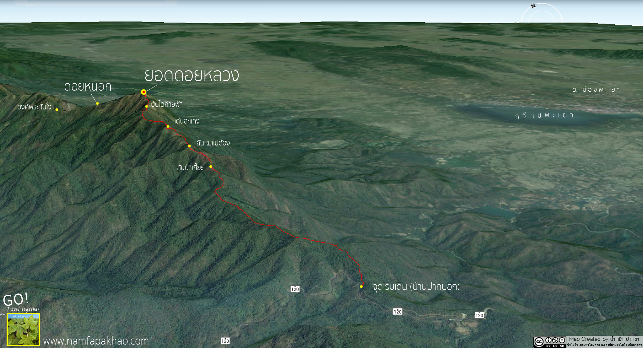
Here is the map I recorded the information and the route on GPS, now I put it on the Google Maps.
This first map is a big scale map. The bold red is the route that the National Park's truck takes us to the walking up point. The thin red is where the truck comes pick us up from the way back.
And the blue line is our walking trail.

This second map indicates the details of walking trail with distances to Doi Luang Summit from Ban Pak Bok.

Ok, if everyone is ready, let's go!!!!
The first kilometer.
We hike up about 1,000 m above the sea level with about 10% steep. We cross the street and start walking paralleling with the main road before the steep increases and the left road starts to get smaller and finally disappears.
After that, it turns to a 90 degree turn and go up to the first hill. Our first km is greeted by steep hill already.
The first hill should be called Noen Pan (meaning a thousand hill---I name it). We rest for a while as our body has yet adjusted. Let's think of this as a warm up exercise.
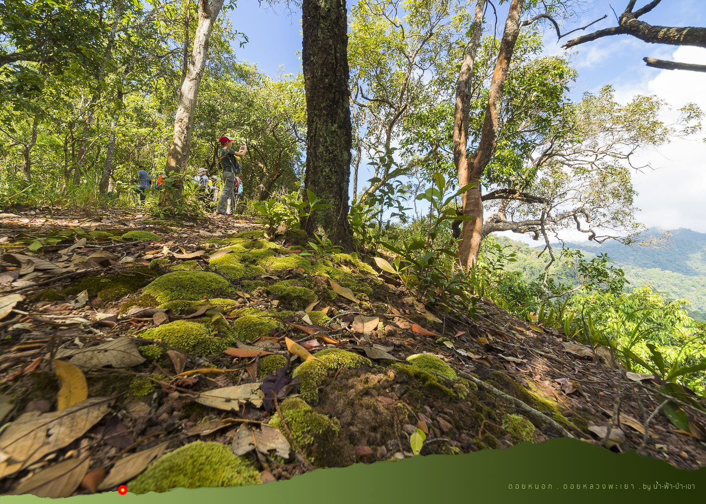
After resting from the first hill, we continue on our second hill. Actually, we are walking on the ridge for quite sometimes.
Left is Lampang and right is Phayao.
The forest is open with the cold breeze from times to times. The shades are there along the way. I pretend to look at the flowers while taking some rest too, hehe.
I know some of them and don't know many. The flower that looks like a jar is called Klong Kleng. It has so many medical benefits. It is one type of herbs.

After the second hill is over, now it's more relax with some slope down routes as well.

The staff points to the shell of pine tree which is all burned with a knife trace.
He explains that this outer shells are burned and cut out to be the fuel starter. He also cut it out and demonstrates it by firing none up for us.
That shell is filled with pine tree oil and easily catches the fire.

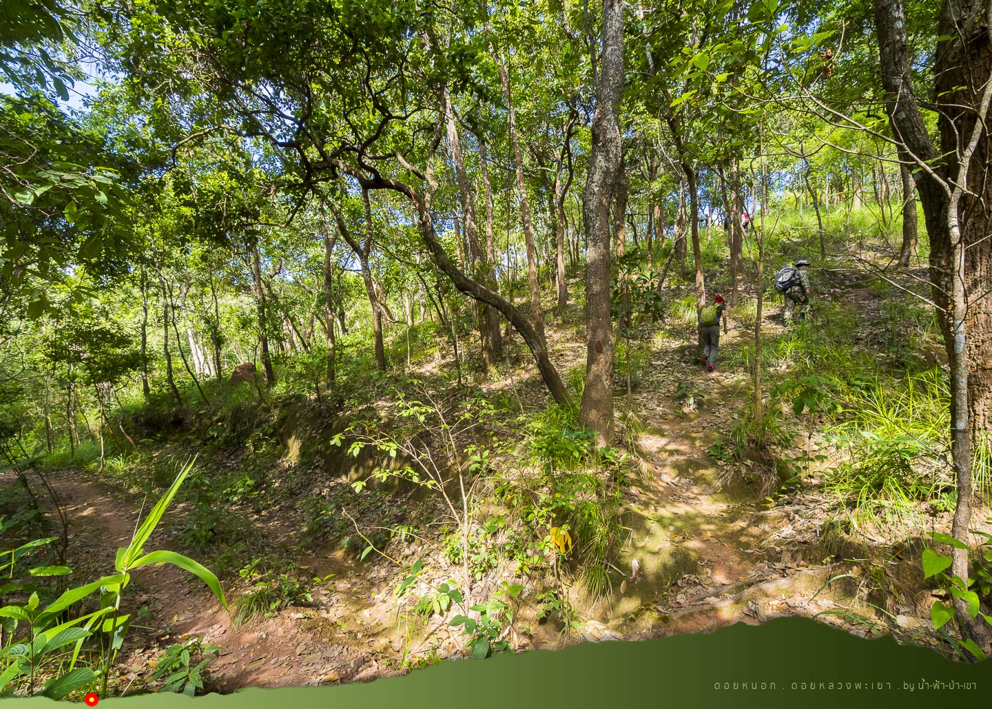
Now the ridge continues its steep. From only a pan (thousand), now it becomes more. After two hours walking, we completed 4 km. We now see the mountain ridge with a line of pine trees on the right.

And after 2 and a half hours, we now reach....
San Pa Kia, the middle way towards Doi Luang
After 4 km walk, we can more or less call it the middle of our destination. San Pa Kia is where several types of pine trees are abundantly grown and thus originates this name.
That here is the pine forest with some plain area and it's already 12.30 p.m., we have our lunch here and take a break for about 50 minutes.

In front of San Pa Kia, we see the long ridge, it is....
San Moo Mae Dong, the First of Very Steep Path of this Route
The mountain ridge here is small and narrow. Moo Mae Dong refers to a pig mother that raises her children until she is very thin that we can see her spine.
The small and narrow mountain ridge is like the Moo Mae Dong. We watch it quietly and think that, it's quite steep. After conquering this ridge, our lunch will also be all digested.

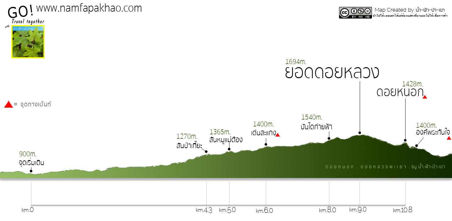
While we are taking a long rest, let's see the map showing the height of these mountains.
This is the elevator map that I also record the distance between important points.
Facing San Moo Mae Dong
Ok, now it's time to move on. After going out of pine trees and the plain area, it's time to conquer the San Moo Mae Dong.

This ridge is about 400 m long. We hike from the attitude of 1,300 m to 1,380 m which takes about half an hour.

Here is the view at San Moo Mae Dong when looking far back to San Pa Kia while resting at the San Moo Mae Deng. Looking far ahead makes us quite exhausted as well.
Because what we see is a long steep path!

This rock looks strange; it's like someone paints it up. It's along the way when we hike up to San Moo Mae Dong.
At the 6th km
Facing the Den Sa Kaeng, the Second Continuous Steep and Long Path
Den Sa Kaeng is a Northern Lanna word. "Den" means open area while "Sa Kaeng" means lie on one side or lean. Some people also call it Sa Kaeng Field. The name tells us that this is the open leaning area.

Now, we are at the height of 1,400 km above the sea level. Standing on the Den Sakaeng and looking back is quite beautiful and tiring.
Hikinh up to Den Sakeng is longer than the one in San Moo. It is about 600 m and take us half an hour.
And now we are standing at the attitude of 1,500 m.

Let's take a break by appreciating the flowers and nature like usual. The weather is also nice and we feel cold when the wind blows.

It's quite enjoyable seeing different colorful flowers.

Hoe Lued Nei
The staff introduces another herb to us. The local language is called "
Hoe Lued Nei". Nei means melt. It can dissolve the blood clot or bleeding, something like that.
I also forget some part of it. It is said that it's quite rare and only found widely at this mountain. The herbal part lies at its root.
The staff pulls one up and we see its reddish root. He then cut it off and put it inside the rice alcohol. After shaking a while, the entire alcohol becomes red. He then said that just leave it like this and we can enjoy it at night. Also, it will help
ease out all our soreness from hiking up here!

Tiny beauty along the way is simply happens when comparing the different leaves.

Let's continue hiking, all our muscles are ready for a long time now.

Moving to the 8th km
Now, we stop in front of "Ban Dai Kai Fah" which is also steep.
Ban Dai Kai Fah (Hike up Sky Stairs)
The Last Steep Path before Conquering the Summit
It is the steepest path of this route. It is the narrow and steep mountain ridge which makes it look like we are climbing the stairs leading to the sky.

And it's in front of this Ban Dai Kai Fah, that we finally see
Doi Nok on the far left.
Let's hike up to the sky! The weather is open with a cool wind. It's steep but not long. Only after 200 m, we now
on top of Ban Dai Kai Fah.

Doi Nok is the highest destination of this trip which we will hike tomorrow. For today, our destination is the camping area at Doi Luang Summit.

We stand to rest a while on Ban Dai Kai Fah. Thank you
Keen Thailand for supporting this trekking shoes. I've used it several years and I personally really like it, Keen Newport H2.
I choose to wear it only when I need to trek in a hard trip as the shoe is thick with a good rubber.
It's very good at sticking to the floor as it's designed to have extra side.
What I like the most is the ankle strapping system. It's designed to protect our toes to not touch the shoes. So we won't have to worry about losing our finger nails.
I didn't get anything from saying all this but I just want to let you guys know, hehe.

Doi Luang Summit
Finally, it reveals in front of us!
The energy is now charged again as we are very close to our destination. Now we are on the 1,620 m above the sea level and it's very close to complete the mission.
We take about 7 hours for rougly 8 km route.

My watch tells me that it's now 17.07 p.m. The sun is about to set. The golden hour just makes everywhere looks so beautiful.
The sun is set earlier during the winter. The GPS in my hand tells me that the sun is going to set at 17.43 p.m. so we must hurry now.

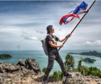
Finally,
our two feet are standing on the Doi Luang Summit. We are too late for the sunset as it's already gone while walking up here TT

Standing at 1,694 m with the sign is to prove that Nai Nam Fah has already stood on Doi Luang Summit, Phayao.
Even though we are late for the sunset, we are here to see the last light of the day which is all golden and yellow shining over the sky.....so beautiful...at this moment, we forgot all about our exhaustion for a while ^^

Here is Doi Nok looking over from Doi Luang Summit. It is our destination for tomorrow.

From here over looking far beyond the horizon to the north western, we will see the summit of
Doi Luang Chiang Dao.
Although it's as far as Chiang Mai, we can see it from up here at this time. This is a far over looking across two provinces of Phayao and Chiang Rai to Chiang Mai!
From what Google Earth tells us, it is 95 km from Doi Luang Phayao to Doi Luang Chiang Dao. After taking the photo of the summit sign photo, let's take the last light photos!
My tripod is still with Look Hab. It's lucky that I have mini tripod in my backpack which I got it from Outdoor Innovation. Then, I set it up and it works quite well.
Let me say goodbye to our first episode of the review here, see you guys at my second episode of how we conquer the challenging steep at Doi Nok soon!

Here, I would like to thank the sponsor: The Tourism Authority of Thailand, Chiang Rai-Phayao Branch contact number is 053-744674-5
And I also would like to thank other travel sponsors:
Nok Air
Avis Thailand
Outdoor Innovation
Keen Thailand
And finally, I'd like to thank every relevant staff at the Doi Luang National Park.
Here is a bit more of the map in Earth View lively taken from the GPS.
For more information, you can talk to me at:
https://www.facebook.com/Namfapakhao/
Thank you for reading until this line. I hope this review is beneficial for you guys.
Doi Nok and the challenge is waiting in the next episode. I have to say that the location of second night camping is one of the most beautiful ones for those who love trekking...
|