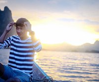


This trip came about because we wanted to walk on the back of a whale swimming through the jungle, following in the footsteps of Is and Pond from Lomphai Phook Rak. We got up, poked the calendar, chose a date, and then planned the trip. The more we researched, the more we found that Bueng Kan has many amazing tourist attractions. We could hardly wait for the day of our trip.
We departed from Bangkok at 11 p.m. on a Nakhonchai Air bus, arriving in Udon Thani at nearly 7 a.m. Upon disembarking at the bus station, we took a three-wheeled vehicle to pick up our rental car at Udon Thani Airport, as Bueng Kan lacks a comprehensive transportation system for tourists. Self-driving car rentals are therefore the most suitable option.
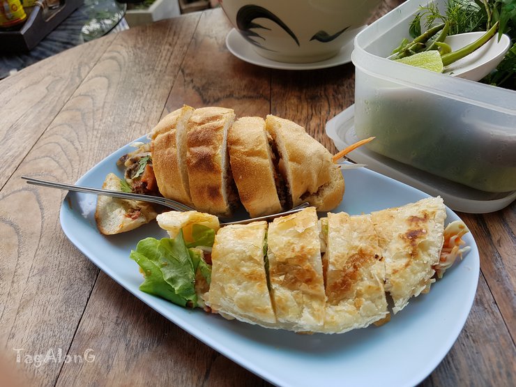
After picking up the rental car, we decided to grab some delicious local food. For breakfast, we opted for Madam Pahtehh, a renowned breakfast spot in Udon Thani. We indulged in their signature dishes, including pate-stuffed bread, roti with condensed milk, pork pho, and freshly brewed coffee.
This small, single-unit shop is always bustling with customers, its tables constantly full. The waitresses, who are likely in their late middle age, may appear somewhat stern but provide attentive and efficient service.
The paté-filled bread is quite tasty, but the liver spread is a bit coarse and the texture is not smooth.
Roti Tid Puan, a dish with an intriguing name. When I ordered it, I had no idea what the filling would be. Upon taking a bite, I discovered it was filled with a refreshing vegetable salad. It was surprisingly delicious and quite enjoyable.

The pork stew had an acceptable taste, but it wasn't quite to my liking. I didn't enjoy the addition of tomatoes, which gave the broth a slightly sour flavor.
The freshly brewed coffee has a strong, satisfying flavor.
After finishing breakfast, we stopped by Nong Prajak to visit the yellow ducklings. This time, we were surprised to find the big yellow duck mother back, swimming near the shore. This was a welcome change from our disappointing trip to Udon Thani last year, where we only saw two ducklings.
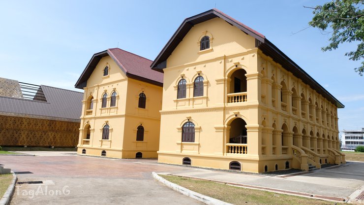
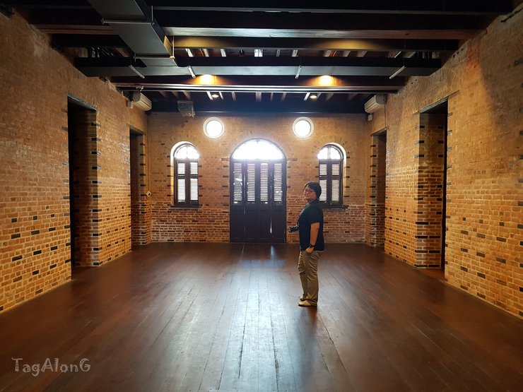
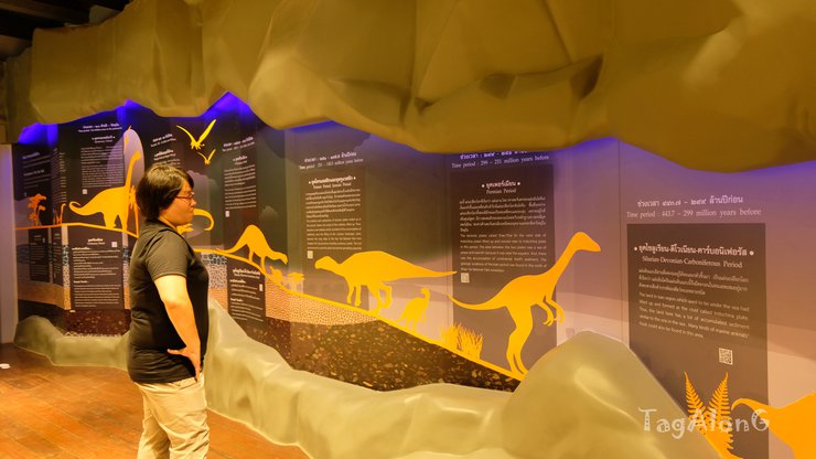
This time, we returned to Udon Thani knowing that the Udon Thani City Museum was open for visits. We planned to stop by for about half an hour. We circled the Nong Prajak Public Park a few times looking for the entrance, as our GPS was malfunctioning and placing pins all over the place. In reality, it's quite easy to find if we trust our own eyes more than the GPS.

The Udon Thani Provincial Museum: A Journey Through History and Culture
The Udon Thani Provincial Museum is housed in two distinct buildings. The Queen Nuthisa Building, a colonial-style structure reminiscent of French architecture found throughout Laos and Vietnam, was once a girls' school. Today, it showcases permanent exhibitions on the history of Udon Thani province, including local beliefs, culture, and traditional lifestyles. The newer building hosts rotating exhibitions, though none were on display during our visit.
Beyond the architectural charm of both buildings, the museum's interior offers engaging exhibits and interactive elements. What we initially planned as a brief 30-minute visit turned into a captivating 90-minute exploration. Admission is free, but donations are encouraged to support the museum's upkeep.


It was late, and we had to hurry to Bueng Kan. We drove almost two hundred kilometers across the province to Phu Tok, taking the route through Sakon Nakhon. We drove past rice fields with lush green rice plants all the way, completely erasing the image of Sakon Nakhon as a dry and barren land that we once had in our minds.
The car reached the bridge over the Songkhram River, where a giant fishing trap, known as a "sadung" in the Isan dialect, was visible on the riverbank. Crossing the bridge marked the entry into Bueng Kan province.

We arrived at Phu Tok at almost three in the afternoon, leaving us only two hours to explore as Phu Tok closes at five in the evening.

Visitors to Phu Tok are required to dress modestly and maintain respectful conduct in both speech and behavior. This is due to the site's status as a place of meditation practice.


The ascent to Phu Tok is not arduous, with wooden stairs leading up each level. However, the incline is significant, requiring caution and mindfulness with every step. The climb to Phu Tok could be considered a form of meditation practice.
In the Isan dialect, "Phu Thok" refers to a solitary mountain peak, not part of a mountain range. Phu Thok is divided into Phu Thok Yai (Big) and Phu Thok Noi (Small), two separate mountains located close to each other. However, the religious site accessible to visitors is located on Phu Thok Noi.
Phu Thok is divided into 7 levels, but people usually only climb to the 6th level because the 7th level is a deserted area with no buildings or viewpoints. We walked through the 1st and 2nd levels quickly and in a daze. Before we knew it, we were at the 3rd level. There was a fork in the road, with both paths leading to the 4th level. The paths were slightly different in length. We chose the right path because it looked more fun to walk.
On the 4th floor, a wooden balcony path begins to wind around the mountain, and the thrill begins to set in. Each wooden plank looks incredibly old, making us secretly fear that it won't be able to hold our weight. To make matters worse, the planks are spaced far apart, creating gaps that allow us to see the ground below, further increasing the tremor in our legs. We must admit that we spent more time looking down at our feet than at the surrounding view. An uncle and his nephew started walking but then turned back, saying they couldn't do it; their hearts were pounding. But if you're feeling brave, give it a try. We were a little apprehensive, but we weren't going to let something like this stop us. We decided to take each step carefully and mindfully. As soon as we rounded the rocky corner, oh my god, the view was breathtakingly beautiful. After a while, the uncle and nephew followed us, and now they were following in our footsteps.


As you ascend to the fifth floor, a path diverges towards the Buddhist sanctuary, majestically perched on a rocky outcrop. The open-air vihara, devoid of walls, welcomes a refreshing breeze. Inside, a Buddha statue invites devotees to pay homage and recite prayers. However, finding tranquility for meditation might prove challenging due to the constant stream of visitors.


The Buddhist temple offers a nearly 360-degree panoramic view. From this vantage point, we have a clear view of the majestic Phu Tok mountain range. Turning around, we are greeted by the breathtaking sight of the wooden walkway on the 6th floor, winding its way along the reddish-orange cliffs of the smaller Phu Tok mountain. Looking back 50 years, with the engineering and construction technology of that era, it is difficult to imagine any tools that could have facilitated such a construction. It must have been driven by unwavering faith and extraordinary effort. The sheer courage and determination required to lay each wooden plank must have been immense.


The Rough Terrain of Phu Thok
Phu Thok, a mountain composed of rough-textured sandstone, presents a challenging yet rewarding hiking experience. While the coarse surface offers excellent traction, preventing slips and falls, areas covered in moss can become slippery, requiring careful navigation.
The wooden walkway on the fifth floor feels more comfortable to walk on than the others. The wood appears new, thick, and sturdy, and the planks are laid close together with minimal gaps, creating a sense of security and ease of movement. This allows for unobstructed enjoyment of the scenery below.
Ascending to the 6th floor felt like a testament to the beauty that emerges from hardship and altitude. The curved cliff face seamlessly integrated with the walkway, creating a vista as breathtaking as the one below. As I walked on this level, I felt weightless, as if I were truly floating in a heavenly realm.


Unfortunately, we didn't have much time to soak in the atmosphere up here, as it was nearing closing time. We had to hurry down, but three hours would have been ideal to fully appreciate the surroundings.
Phu Tok is a must-visit destination in Bueng Kan Province. It is no wonder that the province has designated Phu Tok as its most important landmark, even featuring it on the provincial seal and in the first line of the provincial motto.
After descending from Phu Tok, we had to drive to our accommodation in the city center, which was more than 40 kilometers away. We ended the first day with a sense of satisfaction.
Day Two: Exploring Waterfalls in Sakon Nakhon
Our second day was dedicated to exploring the waterfalls of Sakon Nakhon. However, we woke up late and didn't leave our accommodation until after 10:30 am. We stopped for a delicious papaya salad and grilled chicken lunch on the way, before driving towards Seka district, located about 60 kilometers from the city center.
Our initial plan was to visit Tham Phra Waterfall first. However, we somehow ended up at the entrance of Chet Si Waterfall instead. Upon inquiring with the staff, we learned that Tham Phra Waterfall was still a considerable distance away. So, we decided to go with the flow and explore Chet Si Waterfall first.
The entrance fee was 30 baht per person, and an additional 40 baht for driving our car into the park, totaling 100 baht. Fortunately, the ticket allowed us to visit Tham Phra Waterfall as well, and any other waterfall within the Vua Phu Wildlife Sanctuary.
After driving 2 kilometers from the entrance, we reached the parking lot. Several shops selling similar snacks and drinks lined the area. As we continued walking, we encountered park staff checking our belongings before allowing us to proceed to the waterfall. If we had any plastic bottles, bags, food wrappers, or styrofoam cups – anything that could potentially become litter – we would have been charged a 40 baht deposit per item. Upon returning, we could show the staff the items and receive our deposit back.


The path leading to the seven-colored waterfall is a large stone platform with beautiful patterns formed by the erosion of water and wind. The waterfall is divided into four levels. The lower two levels are streams and shallow pools with gentle water, suitable for children. We continued our journey through the forest to the third level.

The third tier was extremely slippery and dangerous, the most adventurous part of our waterfall exploration that day. We had to hold onto the ropes provided by the park rangers and walk on slabs of rock covered by strong currents. Moreover, the rocks were thickly covered with moss, making it even more difficult to walk. A misstep could lead to a fall and being swept away by the current. We had to be mindful, hold on tight, and take each step carefully. After scrambling over a large boulder, we finally reached the top tier, a high waterfall and a large pool, perfect for swimming. We saw two or three people having fun sliding down the rock slabs under the waterfall. However, at that moment, we didn't feel like playing because everything seemed slippery. Just sitting and listening to the sound of the waterfall was enough to make us happy.


We sat there for about 15 minutes, but then decided to head down because we were worried we wouldn't make it to Tham Phra Waterfall in time.
Finding our way to Tham Phra Waterfall remained a challenge, as the GPS consistently led us astray. We abandoned the GPS and resorted to the traditional method of asking for directions along the way. This led us to the first pier, marking the first time we relied on asking for directions to reach our destination.
The pier area offers shops, restrooms, and showers for visitor convenience. We purchased boat tickets for 20 baht each and stocked up on snacks before boarding. Life jackets are mandatory on the boat at all times. The boat slowly navigated the river bends, passing cool breezes and dense greenery along the way. If the entrance is this beautiful, what wonders await us at the waterfall itself? After a 10-minute boat ride, we reached the landing point. Disembarking, we encountered a ticket booth where we presented our tickets purchased at the Erawan Waterfall. The staff welcomed us and allowed entry. As we ascended the stairs and entered the forest, we were awestruck by the sight before us. It was a waterfall of pure natural artistry. The rock formations, pools, and cascading water were arranged in perfect harmony. The most remarkable feature was the intricate patterns on the rock slopes and cliffs, resembling delicate brushstrokes.

We crossed the high rocky hill to the second tier of the waterfall, the highlight of this waterfall and the spot where Is and Pond had their sweet moment. We saw people climbing the rocks under the waterfall, laughing happily. After some hesitation, we decided to wade through the water towards the waterfall. The water was surprisingly shallow and easy to walk in. Feeling more confident, we slowly inched closer to the point where the water hit the rocks, creating a spray of foam. It was amazing! The cold water was refreshing, and the force of the water hitting our bodies felt like a great muscle massage.


Beyond the scenic beauty of the waterfall, a thrilling activity awaits: sliding down the natural rock chutes. These chutes, scattered throughout the waterfall, cater to various skill levels, from beginner to advanced. While we opted for the elementary level, which proved to be exhilarating enough, more adventurous visitors can challenge themselves with higher difficulty levels.
Visitors planning to use the slide should wear thick pants to avoid potential tears. Even thick denim jeans may not provide sufficient protection.

After an afternoon of fun in the water, it was time to close at five o'clock. Staff escorted everyone out of the area and onto the last boat back to shore.
Today was truly an enjoyable day. The waterfall was stunning. Before returning to the city, we decided to drive to Kham Somboon Beach on the edge of the Mekong River. We hoped to catch a beautiful sunset there.
The road leading to the beach was rather deserted, with only our car speeding through the rubber plantations on both sides. We arrived at Kham Somboon Beach at around 6:00 AM, knowing it to be the most scenic viewpoint of Phu Langka. However, we were met with an eerie silence and emptiness, making us hesitant to get out of the car. The area was lined with restaurants, but devoid of people. We couldn't find a spot to admire the view without having to sit down for a meal. As the sky began to dim, we quickly turned around and headed back to the city.
The heavy rain poured down for an hour, darkening the sky and soaking the earth. However, we sat in the cozy restaurant, enjoying the delicious and warm Korean BBQ. As the rain stopped, we were perfectly full and headed to our accommodation.
Day Three
We left our accommodation at 8:30 am and had breakfast at Ton Khao Piek, a popular breakfast restaurant in Bueng Kan. We didn't order Khao Piek, but the porridge and bread were delicious. We also bought two more pieces of bread to take with us as provisions.
As we boarded the car, we set off for Phu Sing. Today, the GPS took us on a different route out of the city. The road was lined with rice fields and forests, and there was no sign of any community. After driving for about 20 kilometers, we saw a sign telling us to turn. We drove on for another 5 kilometers and saw a sign for Phu Sing Forest and a turnoff. We stopped the car and looked at each other, unsure of what to do. The GPS told us to drive straight for another 20 kilometers before reaching our destination. This time, we decided to trust our instincts, turned off the GPS, and turned the car around.

Continuing our drive, we soon arrived at the Phu Singha Forest Office. We parked our car in front of the information center and went inside to register and rent a vehicle for our ascent to Phu Singha. The road leading up to Phu Singha is quite rough, requiring a high-clearance four-wheel drive vehicle to navigate safely.

We arrived at the destination around ten o'clock and were the first two tourists of the day. We paid 500 baht each to rent a pickup truck to go up the mountain. Mr. Nu, a forest conservation volunteer, informed us that there are a total of 10 sightseeing points in Phu Sing Forest, including Lan Tham Phu Sing, Hin Sam Wa, Tham Rishi viewpoint, Hin Hua Chang, Tham Yai, Hin Chang, Kamphaeng Phu Sing, Pratu Phu Sing, Huachai Phu Sing, and Saeng Roi Bo.

However, our guide informed us that due to the rainy season, only 8 viewpoints were accessible. He advised against visiting Hin Hu Chang and Tham Yai due to slippery paths and the need to cross small water barriers. We exchanged glances, understanding each other's thoughts. We asked our guide if we could attempt the hike, reasoning that we had already arrived and could turn back if necessary. He agreed, assuring us that it wasn't dangerous, just muddy and slippery.
Our driver and caretaker for the day was none other than our older sister, P'Noo. She gave us the choice of sitting in the car or the back of the pickup truck. Naturally, we jumped into the back of the truck.
The car drove up a good road, passing a temple, and stopped at the Tham Phusingh clearing. We were allowed to get out and pay our respects at the temple for a short while before continuing our journey.

The road became increasingly bumpy, causing us to bounce and slide around in the back of the pickup truck. My friend asked if I wanted to sit in the front, but I wanted to stay close to nature. The road was lined with bamboo forests, where locals were digging for bamboo shoots to sell. My friend told me that he doesn't dig for them himself, but instead buys them for 20 baht, which is enough for a large pot of curry. He said it's not worth the effort and risk of being bitten by a snake. The bamboo forests are a prime habitat for pythons and king cobras.


After a 20-minute drive, we finally arrived at Hin Sam Waan, the very destination that inspired this trip!
Walking down the narrow path flanked by bamboo forests, my heart pounded with anticipation. My eyes were fixed on the tip of the long, protruding rock formation. As I emerged from the trees, a breathtaking panoramic view unfolded before me. Below, a dense green forest stretched as far as the eye could see, with mountains and Phulangka in the distance. I was walking on the back of a giant whale, with the mother whale on my right and a smaller calf diving into the ground ahead. Reaching the tip of the father whale's rock, I paused to take in the surroundings, trying to absorb the beauty of this whale-shaped landscape. What I saw, felt, and experienced was exactly as I had imagined.


We were captivated by the breathtaking scenery and ran between the mother and father whales, searching for the perfect angle to capture the moment. The best part was that it was a weekday, and there were no other tourists around, making us feel like we had the entire forest to ourselves.
We took so many photos that we ran out of poses, so I asked my guide to take me to the whale's calf. He raised his eyebrows, widened his eyes, and made a slightly surprised face before saying yes, but that no one else goes there because there's no view and the path is quite slippery. We still insisted on going because we didn't want to be left wondering. So, he led us through the bamboo forest to the whale's calf. As we walked through the thicket of bamboo, I silently prayed that we wouldn't encounter any king cobras. Once we emerged from the bamboo forest, I could finally breathe freely again, but I was then attacked by the poison ivy, which made me itch all over. When we reached the top of the whale's calf, we had a different and beautiful perspective. We were able to take photos with all three whales, and we even saw some elephant dung. I felt that we made the right decision to ask him to take us there.


From the Three Whales Rock, we continued to the nearby viewpoint of the Hermit's Cave. The cave is named after the hermits who once resided there, as evidenced by the rocky outcrop and cave at the cliff's edge.


The panoramic view from the Rishi Cave
The Rishi Cave viewpoint is an open cliff face that stretches for a long distance, unobstructed by trees. This allows visitors to sit, lie down, and enjoy the view to their heart's content. No matter which angle you choose to photograph, the scenery is stunning. Below, a vast expanse of lush green forest stretches as far as the eye can see, resembling a soft green carpet laid out by nature. Patches of cloud shadows cast across the landscape, adding depth and dimension to the verdant tapestry. We were even more impressed by the view here than at the Three Whales Rock. However, be warned: the sun was incredibly strong that day. Lying down to take pictures with our faces tilted upwards, we felt as if our faces were burning, both from the direct sunlight and the heat radiating from the rocks.


The next point is the Elephant Head Rock, which my brother initially advised me not to visit. The path is slippery in some places, but it is manageable with caution. Compared to yesterday's Seven-Colored Waterfall, this is a piece of cake.

Elephant Head Rock is a cliff that resembles an elephant's head when viewed from behind. As you ascend the cliff, it feels as if you are walking from the elephant's back to its head. The view from the top of Elephant Head Rock is breathtaking.


The next stop was a large cave, previously used as a medical facility by the communist group. We had to walk 200 meters to reach it. However, due to the heavy rain the night before, there were puddles of water everywhere. We had to dodge and jump over them, sometimes successfully, sometimes not. In the end, our feet were soaked anyway. The path to the cave was more difficult than other parts of the trail, with several sections of stairs and dirt slopes to climb up and down. The most challenging part was crawling through a bamboo thicket to reach a water-slowing weir. However, when we finally arrived, we were disappointed. There was nothing to see. It wasn't worth the effort. But hey, at least we had a fun adventure.


Subsequent stops were small, so we only spent about five minutes at each one taking photos.
Elephant Rock

Phusang Mountain Wall

Phu Sing Gate

Heart of the Lion

Create hundreds of wells

Our tour of Phu Sing took over four hours, longer than the locals. When we reached the bottom, we saw two other tourist groups who had arrived after us but had already descended while we were eating noodles. Brother Nu told us that most people finish the tour in about three hours, and some only visit the Three Whales Rock.
After taking a break to eat, drink, and use the restroom, we continued our journey. We decided to visit Kaeng Ahong, as it was on the way to Nong Khai and provided a shortcut to Udon Thani.
We drove for almost 50 kilometers. When we arrived at the front of Ahong Silawas Temple, it started raining heavily. We decided to take shelter at a restaurant near the temple and ordered some spicy minced pork salad and papaya salad. The food at this restaurant had a very local flavor, which we were not familiar with, but it was strangely delicious.
Once the rain stopped, we drove to the temple and stood to watch the Mekong River. The backdrop was a mountain range on the Lao side, with clouds drifting and obscuring the peaks. Due to the rainy season, the water was high, so we couldn't see the rapids. However, we witnessed the amazing sight of the current flowing in opposite directions. In some sections, whirlpools were visible. This point is the deepest part of the Mekong River, exceeding 200 meters, and is therefore called the "Navel of the Mekong River."


After a brief stop by the river, I had to rush back to Udon Thani. Along the entire route from Bueng Kan city to the provincial border, there was not a single gas station. However, as soon as I entered Nong Khai province, I came across a large gas station. The roads in Nong Khai are significantly more urbanized compared to those in Bueng Kan, where the landscape is dominated by forests, rice fields, and mountains. Therefore, anyone planning a road trip in Bueng Kan should check their fuel level before leaving the city center.
We arrived in Udon Thani at 7:30 PM and stopped to eat VT Nem Nuong.

After returning the car to the airport at the agreed time, we waited to board the plane back to Don Mueang at 10 pm. This concluded our trip to Bueng Kan, leaving us with a wealth of memories to take home.
In our current opinion, Bueng Kan has risen to the top of our list of favorite provinces. Every tourist attraction in this province is stunningly beautiful, with lush forests, tranquility, and a high degree of naturalness. The number of tourists is still low. If we have the opportunity, we would like to see the sunrise, sunset, and sea of fog on the back of the whale again.
Tag AlonG
Wednesday, February 26, 2025 9:01 PM