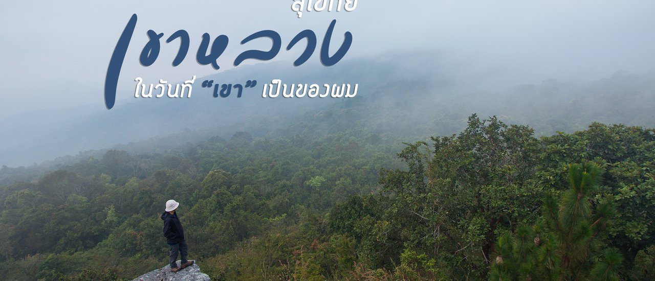


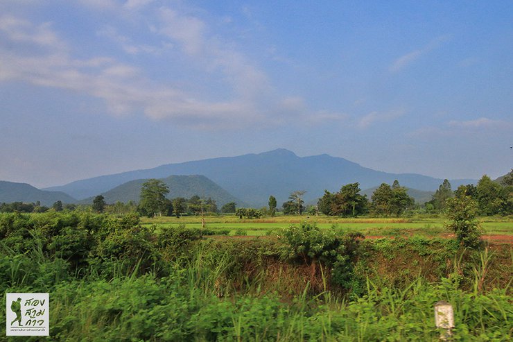
How would it feel to own an entire mountain? It would probably feel like I did when I was the owner of "Khao Luang Sukhothai" for a day. A day on a high mountain with only me and the pure sounds of nature, nothing to disturb me.
The lesser-known Khao Luang, less crowded than Phu Kradueng and Phu Soi Dao, was our destination on Saturday. We had to hike up quickly to secure a good camping spot, as any delay could have resulted in an inconvenient location. But how could I be the only one on such a popular mountain? I'll tell you all about it later.
This trip, I simply wanted to find a place to hike, go on a weekday, and go alone. I felt like my legs were getting weak from overtraining, and I hadn't been hiking for over two months. I decided that there was no better place than Khao Luang Sukhothai, Ramkhamhaeng National Park. I had been there once before, but I didn't have enough time to do what I wanted.
Now is the perfect time to redeem ourselves. Let's pack our bags and go!
(1)
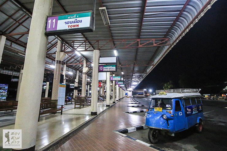
This solo trip began in Korat, where I boarded a late-night bus that arrived in Phitsanulok around 3 am. I then transferred to another bus, reaching Sukhothai by 5 am. The historical city's bus terminal was eerily quiet.

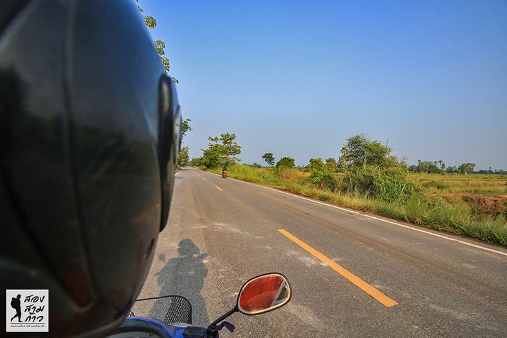
To climb Khao Luang, you need to go to the Ramkhamhaeng National Park office in Kiri Mas district, which is 30 kilometers south of Sukhothai city. The motorcycle taxi driver offered me a price of 300 baht, which is the normal rate. As far as I know, that's what everyone charges. But since I had plenty of time, I wasn't in a hurry to leave.
I spotted a sign for the Khiri Mat bus stop and saw a van heading to Nakhon Sawan, which would pass through Khiri Mat. However, I waited and waited until dawn, even went to grab some breakfast, but there was still no sign of the van. I asked the locals, who told me that this was normal because there weren't many people around.
7:30 a.m. still dead quiet, so I had to join forces with Brother Win for 300 baht. Is it expensive? Compared to the convenience, route, and distance, I think it's okay. It's not a budget price, but it's fair.

Riding on the back of a motorcycle taxi, the majestic Grand Palace stood tall beside them.

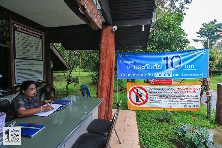
Approximately half an hour from Sukhothai Bus Terminal, you will reach the park's toll booth, where a 40 baht fee is collected. Payment is required. Currently, the park offers accident insurance in collaboration with Krungthai Bank for only 10 baht, covering accidents that occur during hiking. This is an attractive option, but as I already have personal accident insurance, I did not find it necessary to purchase it.

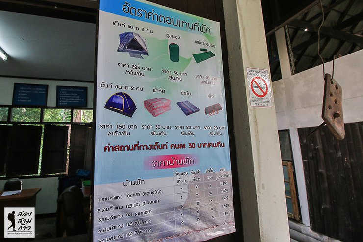
Upon entering the park, the first step is to register and pay the overnight fee of 30 baht per person per night (60 baht for a two-night stay). Equipment rentals are also available at the registration office, with a 200 baht garbage deposit that will be refunded upon returning the garbage. Those who require porters can also arrange it here for a fee of 25-30 baht. I did not inquire about the exact price as I did not use this service.
Today, I registered with two other students from Chiang Rai. I thought that others would follow suit later, but in the end, it turned out that only the three of us were there that night.


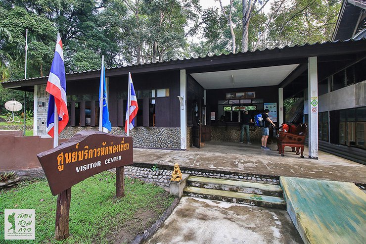
Near the tourist service center, there is a convenience store where you can buy small items before climbing the mountain. You can also order lunch as provisions. Some people may walk fast and arrive before they are hungry, but I know I will be slow. It is best to bring a packed lunch.
Alright, let's pack our bags. This time, it's 19 kilograms, including the entire camera set. That's normal, not less but not more than I've carried before.


The 3.7-kilometer ascent to Khao Luang is mostly steep, with few flat sections. However, it is not considered extremely challenging due to the park's well-maintained stairs and handrails. Nevertheless, it is not an easy climb, as carrying a backpack uphill is never effortless.


Another advantage of Khao Luang is the availability of clean drinking water throughout the first half of the trail. The water comes from a natural spring, which the park has piped down to collection tanks at various points. This means that hikers don't need to carry large amounts of water, just a bottle to refill along the way.

I had ample time to spare, and I was busy taking photos and videos, switching cameras, and setting up tripods. It was a luxury to be able to spend time without rushing, thanks to the early morning climb and the two-night stay.
Approximately 1.6 kilometers from the 3.7-kilometer mark, we reached a scenic viewpoint after about an hour and a half of hiking. We encountered a large group of hikers heading in the opposite direction. Interestingly, there was no fog this morning, which is not surprising given the dry and relatively non-humid conditions.

Walking and resting, taking photos and videos, I arrived at this point at half past one. The giant banyan tree is magnificent. Not far away, there is a small cave. I went in to take a look. Inside, there is a statue of the Mother Goddess.
Who is Phra Mae Ya? According to the belief, it is likely to refer to Nang Sueang, the consort of King Sri Indraditya, or the mother of King Ramkhamhaeng, who was revered by the people of Sukhothai. There is a shrine of Phra Mae Ya in Kiri Mas district. It is a pity that I did not have the opportunity to visit and pay my respects, as the Kiri Mas bus did not arrive.


From the beautiful waterfall, continue uphill for a while, and then it will be a long flat road. After passing the Nang Nak chimney (Nang Phaya Nak, not Nang Nak from the movie), it is only 400 meters to our camping site.


Trail runners with exceptional skills can complete the course in as little as 45 minutes, while the average trail runner takes around an hour. Hikers carrying their own gear can expect to reach the summit in approximately two hours. For those seeking a challenge, this trail offers an opportunity to test their limits.
The campsite has a ranger station where you can rent equipment and purchase small snacks, such as instant noodles, canned fish, and soft drinks.


The campsite has a sufficient number of restrooms, which may not be luxurious but are clean and considered very good for a mountaintop location. As for water, there is no need to worry. Unless there is a severe drought, the campsite always has a supply of water for drinking and other uses. If you are hesitant to drink directly from the tap, you can filter or boil the water for added peace of mind.

After setting up the tent, I relaxed and enjoyed the peaceful atmosphere.

Mount Luang has four peaks: Khao Narai (sunrise), Khao Chedi, Khao Phra Mae Ya (sunset), and Khao Phu Ka. The circular trail is approximately 4 kilometers long. I stayed two nights to complete the hike without rushing.

As the sun began to set, I decided to warm up with a short walk to Khao Phra Mae Ya. The one-kilometer trail offered a moderate challenge with some ups and downs, leaving me with a satisfying sweat.


The Mother Goddess statue stands at the center of the four peaks. My two tent-sharing companions had already arrived and were waiting for me. As we chatted, we learned that they would be descending early the next morning. This meant that I would be the only one exploring the surrounding nature trails, as the new group arriving that day would likely not embark on a hike on their first day.
The sunset today is truly beautiful. The peak in front is Mount Phu Ga.


After returning to the tent, I had a simple dinner. Since I was alone, I didn't see the point in buying fresh ingredients and cooking a big meal. I boiled some instant noodles and added a bit of chili paste, which was delicious.

The sky is clear tonight and the stars are beautiful. The Milky Way is visible in the early evening, stretching across the sky. It is difficult to take pictures of the stars at the campsite because the staff keeps the lights on until 10 pm. If you want to take better pictures, you can walk to the helicopter landing pad or Mount Narayana.
However, I didn't go. The battery died... Was it the camera battery? No, it was my own battery that died. (Laughs...) I'll just find a spot to take pictures at the campsite. I'll just have to make do with what I can get.


(2)
"Where's the fog?" I wanted to shout out loud (lol...). I admit that when I first came here, I secretly hoped to see the legendary sea of fog. But when I encountered the dry air even before I went up, I knew it wouldn't happen. And anyway, I think nature is beautiful no matter what it's like.
Setting the alarm for 5:00 AM, I changed into my gear, grabbed my flashlight, and plunged into the darkness towards the summit of Mount Narai, or Pha Narai, near the Air Force's telecommunications station. The distance from the campsite was only 400 meters. As I mentioned, there was no fog, but the beauty was undeniable.
I arrived at 5:40 am and sat in the darkness for a while. The other two students arrived at 6:00 am. We were the only three people on the mountaintop that day. The atmosphere was peaceful and beautiful. The sound of the wind, birds, insects, and the forest filled the air. It was pure nature, with no artificial sounds except for the click of my camera shutter.


I returned to cook rice porridge to fill my stomach and prepare my belongings for the hike to conquer every peak. The two younger siblings asked to leave the mountain. Now, the entire Khao Luang Sukhothai belongs to me.

9:40 AM: Embarking on a Leftward Loop
The day's trek commenced at 9:40 AM, with a counterclockwise loop encompassing Mount Chedi, Mount Phu Ka, Mount Phra Mae Ya, and Mount Phra Narai. This reversed the previous evening's and morning's clockwise route. The trail was exceptionally well-defined, with clear signage at junctions, eliminating any possibility of getting lost. The initial stretch, leading to Mount Chedi, spanned approximately 1 kilometer and boasted scenic beauty.


It takes no more than twenty minutes to reach the top of Chedi Mountain, where there is a pile of Chedi stones. According to the sign, the height here is 1,185 meters. Find a viewpoint above the trees. On the right side, you can see Narai Mountain, and on the left side, you can see Phra Mae Ya Mountain and Phu Ga Mountain.

The most breathtaking panoramic view of Khao Chedi requires a short descent of approximately 100 meters. A large rock provides a comfortable perch for posing, with Khao Phra Mae Ya and Khao Phu Ka as the backdrop. As I arrived, mist drifted in, eliciting a gasp of awe.

After taking photos to our heart's content, we continued our journey. Of course, before ascending the next mountain, we had to descend the current one. After walking down for a while, we reached a fork in the road. The left path led to Khao Phuka, which was 1 kilometer away. We decided to take that route.

The mountain peak appears to be towering, but the path back is not very steep. This is because the trail winds around the shoulder of the mountain to ascend a less steep side. The forest scenery is quite beautiful.

The provided text is empty. Please provide the text you want me to translate.

Upon reaching the summit, I was immediately struck by the breathtaking beauty of Phu Ka Mountain. Standing at an impressive 1,200 meters, the peak offered panoramic views that were both awe-inspiring and serene. As I arrived, the mist was gently rolling in, creating an ethereal atmosphere. After a brief wait, the fog dissipated, revealing a stunning vista that unfolded before me. The solitude of the moment, coupled with the magnificent scenery, filled my heart with an indescribable sense of joy and wonder.


From the summit of Phu Ga, one can see three other peaks lined up. The leftmost is Khao Narai, the middle one is Khao Phra Mae Ya, and the rightmost is Khao Chedi, where we have just walked. It is surprising that despite the distance, it did not take as long to walk as we thought.

This image captures the moment when the fog from Mount Narayana envelops the statue of the revered Ya Yai, creating a truly breathtaking scene.

For lunch, I had rice and pre-packaged instant food that I had brought with me. I spent hours wandering around, enjoying the scenery and listening to the sounds of nature until I was full. At around 2:15 pm, I continued on to Khao Phra Mae Ya, which required me to return to the three-way intersection we had passed earlier.
The view from Phra Mae Ya Temple is breathtaking, especially with the clear sky. I've only been here during sunset before, so this is the first time I've seen the vibrant colors of the sun. The sunshine is intense, but I don't mind. Phra Mae Ya Temple is located at an altitude of 1,200 meters, the same as Phu Ga Mountain. I think this is an approximate figure, not an exact measurement.


From Khao Phra Mae Ya, looking towards Khao Phra Narai, you will see the telecommunications station and a protruding cliff called Pha Chomprong. We will walk there now.

This is Pha Chomprong, a cliff accessible by walking along the fence of the telecommunications station. The name "Pha Chomprong" comes from the abundance of cycad trees ("prong") growing along the cliff face.


The final destination was the 1,160-meter-high Narai Peak, where I captured some stunning photos of the surrounding landscape. I stayed at the Narai Cliff until 4:30 PM, and on my way back to the campsite, I encountered other hikers who had just started their ascent that day. We exchanged greetings and continued on our separate paths. Most of them were heading to Khao Phra Mae Ya to witness the sunset.

The campsite was livelier today, Friday, than yesterday. Two large groups arrived, along with three or four smaller groups of two or three people each, bringing the total to around twenty people.
This evening, I planned to walk to photograph the Milky Way around 7-8 pm. However, the sky was covered with clouds and there was lightning. I could only shrug my shoulders in the tent. What can I do?
(3)
Saturday - I woke up at 5 am again and walked through the darkness to Pha Narai first, as usual. What was different was that if yesterday the sky was completely clear, today when I arrived at 5:30 am, there was only thick white fog covering everything. I started to have a little hope that if the fog cleared, I might see a sea of mist.
However, the reality is not that simple. While the fog was indeed thick, there was no sea of mist. Nevertheless, the atmosphere was still beautiful. I arrived first before dawn and was the last to leave Phra Narai Rock at 7:30 am when the sky was bright. Sitting and listening to the sounds of nature around me was incredibly peaceful.


After having breakfast, packing up, and dismantling the tent, it was already 11:00 AM when we started our descent. However, the descent was quick, taking no more than two hours to reach the bottom. We encountered hundreds of tourists making their way up as we descended.
The same place, on weekdays and weekends, is as different as night and day.


As I ascended the mountain, I encountered a large group of hikers at a scenic viewpoint. They informed me that this was their fourth attempt to witness the sea of mist, but they had yet to be successful. Despite their lack of luck, they remained determined to continue their pursuit until they could experience the breathtaking spectacle that others had described.
This is only the second round for me, so there must be a next time. See you again when you miss me.
Khao Luang National Park, Sukhothai
How to get to and explore Khao Luang National Park in Sukhothai
Ramkhamhaeng National Park: A Guide for Hikers
This guide provides information for those interested in hiking to the summit of Khao Luang in Ramkhamhaeng National Park, Thailand.
Location and Access:
- The park's headquarters and Khao Luang are located in Khiri Mat District, approximately 30 kilometers south of Sukhothai city.
- The park is open year-round and reservations are not required. However, contacting the park beforehand is recommended to check for any closures or restrictions.
- During the Constitution Day holiday in December, the park hosts an annual event celebrating the conquest of Khao Luang. Hikers are advised to avoid this period due to the large crowds.
Transportation:
- From Bangkok: Take a bus to Khiri Mat District. The journey takes approximately 4 hours.
- From Sukhothai:
- Motorbike taxi: A motorbike taxi from Khiri Mat to the park entrance costs 160 baht each way.
- Pick-up truck: For groups, a pick-up truck can be hired for around 400-500 baht, depending on the number of people.
- Bus: From Sukhothai Bus Terminal, a motorbike taxi to the park entrance costs 300 baht each way.
- Songthaew: For groups, a songthaew can be hired for around 600 baht or more, depending on the number of people.
- Park transportation: The park offers transportation services from both Khiri Mat and Sukhothai. Contact the park office for details and pricing.
Fees:
- Entrance fee: 40 baht per person
- Vehicle fee: 30 baht for cars, 20 baht for motorbikes
- Camping fee: 30 baht per person per night
- Garbage deposit: 200 baht (refundable upon proper disposal of garbage)
Hiking Information:
- Registration: Hikers must register at the visitor center before starting their ascent.
- Start time: The trail opens at 8:00 AM. Hikers are not allowed to start after 2:00 PM.
- Distance: The hike to the summit is 3.7 kilometers.
- Duration: The ascent takes approximately 2.5 hours for a moderately paced hiker.
- Difficulty: The trail is considered moderately difficult. It consists mainly of dirt stairs with handrails in steeper sections.
- Facilities:
- Clean water is available at designated points along the trail.
- Basic supplies like instant noodles and canned fish are available for purchase at the campsite.
- Cooking is permitted on designated camp stoves or charcoal grills. Open fires are only allowed in specific areas.
- Camping equipment can be rented at the visitor center.
- Toilets are available and maintained by park staff.
Additional Information:
- The summit offers stunning views of the surrounding landscape.
- There are four peaks on the mountain: Khao Chedi, Khao Phu Ka, Khao Phra Mae Ya, and Khao Narai. Hikers can explore all four peaks, covering a total distance of approximately 4 kilometers.
- A two-day, one-night trip is sufficient for a quick but strenuous hike. For a more relaxed experience, consider a three-day, two-night trip.
- For further inquiries, contact the park directly at 0559100001 or 0988839297.
Follow my travel adventures on another channel.
http://www.facebook.com/alifeatraveller
นายสองสามก้าว / A Life, A Traveller
Wednesday, February 26, 2025 9:43 PM