
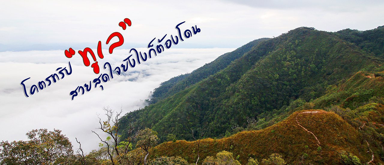


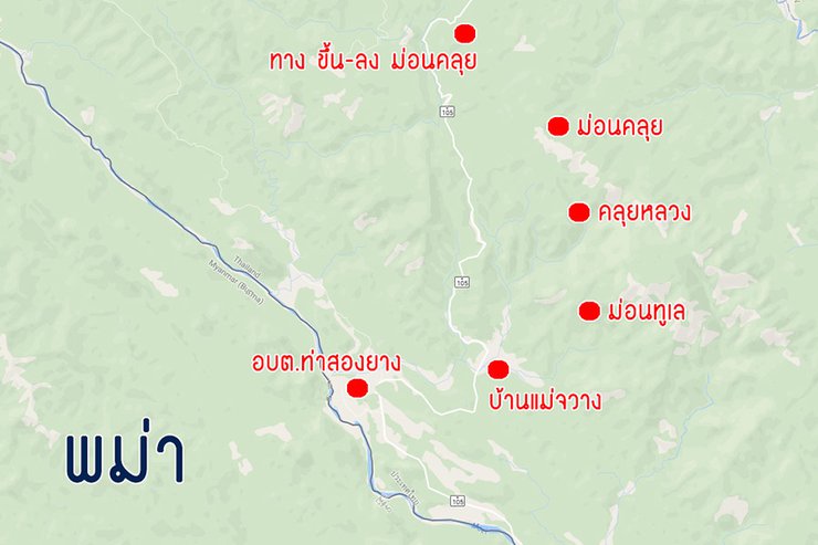
Embark on a thrilling adventure to the golden mountain, Mon Thu Le, in Tha Song Yang District, Tak Province. This three-day, two-night expedition will take you on a journey through the stunning landscapes of northern Thailand. Beginning at the starting point, embark on a trek to Mon Thu Le, a majestic peak renowned for its breathtaking views. Continue your journey to Khlui Luang, another towering summit, before descending to the road intersection. From there, choose to hike or take a vehicle to Mon Khlui, the final destination. Mon Thu Le, Khlui Luang, and Mon Khlui are three peaks situated on the same mountain range in Tha Song Yang District, Tak Province, near the Mae Nam Moei River, which forms the border between Thailand and Myanmar. This itinerary provides a comprehensive overview of the three-day, two-night trek, offering a glimpse into the challenges and rewards that await you on this unforgettable adventure.

The route can be started from either Mon Thu Lay or Mon Khlui. If you prefer a full trekking experience, it is recommended to spend a night at Mon Thu Lay and another at Khlui Luang. Mon Khlui can be skipped as it will be passed by car either on the way to or from the other two locations.
Booking a trip is easy. Simply call the Tha Sao Yang Subdistrict Administrative Organization. All details and contact information can be found on their Facebook page: www.facebook.com/DoiTuLay
**(1) From Mae Jawan, ascend Mount Thu Le.**
This trip, we embarked on our adventure after the New Year. With five members in our group, they had a long break until the third day. Therefore, we immediately set off on our journey on the fourth day (haha...). Coincidentally, we forgot to consider the heavy travel volume on the third day, which disrupted our plans. The only remaining bus from Bangkok to Mae Sot was at 10 pm, a bit late, but there was nothing we could do.
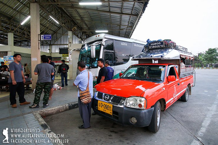
After a restless night, we arrived in Mae Sot around 7:00 AM. We missed the 6:00 AM shared taxi to Mae Sariang, where the Tha Song Yang Subdistrict Administrative Organization (SAO) is located. We had two options: take two short shared taxis or hire a private car. Given the time constraints, we opted for the latter, which cost 1,800 baht, leaving us feeling a bit light in the pocket.

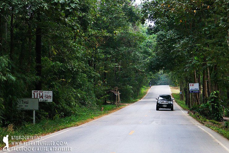
The songthaew sped out of Mae Sot Bus Terminal, stopping for us to buy fresh produce at Mae Ramat Market before entering Tha Song Yang District. It seemed like a short time, but the price was expensive for a chartered ride. However, the car didn't stop, and it continued to speed along the road.


It turns out that Tha Song Yang is a peculiar district. The district's name is Tha Song Yang, but the district office is located in Mae Tan sub-district. The actual Tha Song Yang sub-district is 50 kilometers away from the district office.
If locals are talking among themselves, "Tha Song Yang" likely refers to Tha Song Yang Subdistrict. The district itself is called Mae Taeng. In total, the distance from Mae Sot Bus Terminal to Tha Song Yang Subdistrict Administrative Organization is 140 kilometers. It's a long journey, and you might fall asleep several times before reaching your destination.
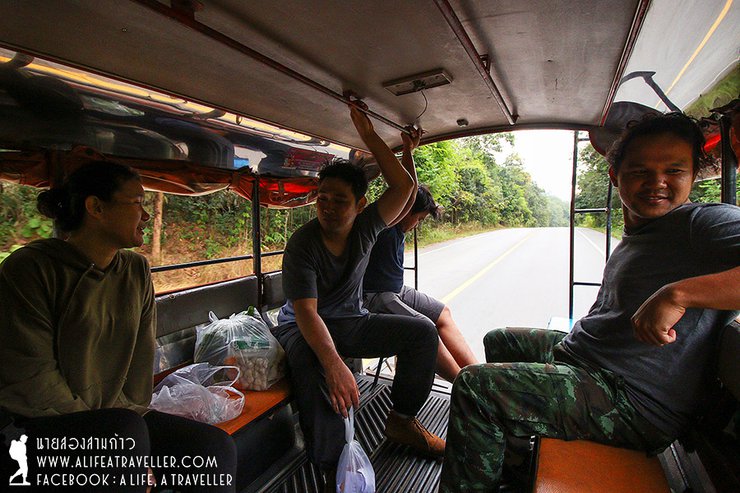
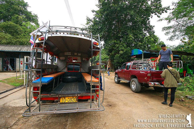
We arrived at the Tha Song Yang Subdistrict Administrative Organization (SAO) at 9:45 AM. The pickup truck for transportation was already waiting. We transferred our luggage and paid the fees to the SAO. The fees included a venue fee of 200 baht per group of five people. The transportation fee was 1,800 baht, and the porter fee was 1,000 baht per person. We paid these fees directly to the respective individuals.


We stopped for lunch before heading to Baan Mae Jawan, a Karen village. Due to a slight miscalculation in the number of participants, we had two porters on this trip. This meant we only had to carry light backpacks, which was a relief for both our bodies and wallets.
Some Karen porters speak Thai, while others do not. It depends on luck. My porter, an older man, did not speak Thai, but fortunately, the young boy with him could understand me. When I asked him what time we would arrive if we started walking now (11:15 AM), given the distance of approximately 7 kilometers, the boy acted as an interpreter and spoke with the porter before replying, "5:00 PM."
Let's hurry up and walk.

We started walking from Mae Jawan village, passing through rice fields that now only have dry soil. We could see the peak of Doi Tu Lay in front of us. After a short climb, we looked back and the view was beautiful. It must be refreshing during the green rice season.


Despite warnings about the challenging terrain of Mon Tu Lay, I initially dismissed them, observing local porters navigate the path effortlessly in sandals.

As we entered the forest, the path became increasingly steep. The climb was arduous, leaving us breathless and exhausted. The terrain was predominantly uphill, with only occasional stretches of flat or downhill sections. Fortunately, the weather was overcast and threatening rain, providing some respite from the scorching sun that is typical of the dry season. Had the weather been clear, the climb would have been considerably more challenging.


We walked at a leisurely pace, taking breaks when we felt tired and sitting down when we needed to. By 2:40 PM, we had reached a special wooden bench. This was a designated rest stop, as the incline from here on would be twice as steep. (Laughter...)

The severity of the situation is evident from the images.


As the altitude increased, the view became increasingly breathtaking. Despite the persistent fatigue, the adrenaline rush provided a much-needed boost of energy. The stunning vistas compelled frequent photo breaks, further contributing to the overall rejuvenation.


And then, at 4:15 p.m. sharp, five hours had passed, so we arrived at the campsite.
The campsite has three main areas. The first is located at the bottom of the hill, just beyond the edge of the forest. The second is slightly higher up, next to a stream. The third is on top of the hill, near the flagpole. The first and second areas have pit toilets available for emergencies, but the overall atmosphere is not ideal. The second area, in particular, has a garbage burning pit. A major drawback of all three areas is the abundance of garbage, which is scattered throughout the trails, campsites, viewpoints, and other areas. The amount of garbage is overwhelming and impossible to clean up completely. It is understood that this is partly due to the fact that we visited after the New Year. However, it is still frustrating to see so much litter.

We reached the summit and decided to camp on the flag hill, a wide-open space near the viewpoint. Two groups were present: us and another group of young adults who had arrived around the same time. We all set up our tents and prepared for the night.


"Don't worry about drinking water, the porters will take care of everything. I didn't personally see the water source, but judging from the water in the bottles, it's clean and drinkable."

The peak of Thulo is not yet at the flag hill. We will wait to climb it tomorrow. Let's take a look at the view around here first. Looking out, it's all Burmese land. As for the Mon Kluy side of our house, there is a lot of fog even though it is evening.


Before dusk, let's cook together. We may not be professional chefs, but working together is fun. Up here in the mountains and forest, whatever we make, we have no choice (laughs...).


After a hearty meal, everyone retired to their beds early, exhausted from the day's activities. The overcast sky, devoid of moon and stars, provided the perfect ambiance for a restful night, preparing them for the excitement of the next morning.
At 5:30 am, the alarm clock went off, rousing us from sleep. We gathered, rubbed the sleep from our eyes, and began the ascent to the summit. From the campsite, it was a 400-meter climb, but despite the short distance, the peak seemed perpetually out of reach, no matter how much we walked.
Exhausted but exhilarated, we finally reached the summit of Mount Toole. From here, we could continue on to the next peak, offering breathtaking views. Although we missed the dramatic sea of mist or the sunrise, we were grateful for the absence of rain and thick fog.


Taking photos at a leisurely pace, exploring different angles. What I love about this place is that wherever you look, you're surrounded by forests and mountains, dotted with small villages. The view is stunning and well worth the trip.


The thick fog on the opposite bank is Mork Kluy. People living there probably can't see much.


We kept taking photos all the way back to the flag hill. My shutter was still working.


(2) Continue to Khlui Luang and then descend to Mon Khlui
Around eleven o'clock, after cooking and packing up camp, we continued walking to the second campsite, Khuluang or Monluang, a distance of about 5 kilometers. The porter boy said it would take no more than three hours, with ups and downs and flat sections, making for a moderately challenging hike.


At noon, we walked down to the stream and filled our bottles with water. (The porters took care of it.)


The summit of Klui Luang is just a stone's throw away, but the final ascent is brutally steep, forcing us to take multiple breaks despite the short distance of a few hundred meters.


At 1:30 p.m., we arrived at the campsite. The initial sight was startling, not because of the thick white fog and light rain, but because of the garbage scattered all over the place, even more than on the planet Tooley. It would probably require a dedicated garbage collection trip to clean it all up.

At three o'clock in the afternoon, our stomachs were rumbling after setting up camp. We decided to cook instant noodles as the sky remained overcast and the wind continued to bring intermittent rain.


As the fog began to thin around 5:30 PM, we seized the opportunity to capture the breathtaking beauty of the clearing sky after the rain and mist.


On Khlui Luang, there was no one else but our group. We owned the mountain. Even when it rained, it wasn't a problem. We huddled together under the flysheet, and it was warm.


Throughout the night, the sound of raindrops pattering on the tent grew louder, punctuated by occasional gusts of wind that caused the structure to shudder. In such conditions, it was hard to imagine waking up to anything other than a blanket of white.
The unpredictable nature of the sea of mist. Waking up at six in the morning, I shouted to everyone, "Hey... sea of mist!" The reason is shown in the picture, no further explanation is needed.


I strolled through the sea of mist, tracing the path from the tent site, capturing the beauty of the scene as I went, until I reached the summit. I can say without a doubt that it was like heaven. Even without the sunlight, the sea of mist stretched out as far as the eye could see, covering almost the entire eastern side.


The other side is equally beautiful, with lush forests and mountains. Today, the mist shrouds Mon Khlui, obscuring the view.


Looking back from this point, we can see the campsite and the path we took. The path is very clear.

Savoring the soft mist and enjoying a hearty breakfast, we finally packed up and left the campsite around 10:30 am.
We descended from Khun Luang along the path to Mon Khun Luang, mostly downhill. Along the way, the fog began to spread due to the wind, creating a different kind of beauty.


Shortly before noon, we emerged from the forest onto the road. This was the designated pick-up point, but it was deserted. Even the old fruit vendor, who never understood our language, exclaimed in Thai, "Where is the car?" To make matters worse, there was no mobile phone signal.

After waiting for a long time, a local villager on a motorbike came by. I borrowed the motorbike to find a place with phone signal. I found out that the car had already come to pick me up once, but I didn't come down, so they went back to do some errands. Now they are on their way from Tha Sao Yang to pick me up again. I feel relieved now, as I thought I was going to be left behind.
On the way down, we stopped to take a picture (with the sign) at Mon Kluy as a souvenir, even though we couldn't see anything but white.


The journey from Mon Kluy to the mouth of the trail, approximately 7.5 kilometers, is primarily on a gravel road. Upon reaching the highway, turn left towards Ban Tha Song Yang. Along the way, drop off the porters at Ban Mae Jawan, paying them 1,000 baht each. Stop for lunch and a shower at the local administrative office (อบต.). Settle the payment with the driver, and the mission is complete. However, the trip is not over yet.
We finished showering at 4 pm. What time does the last bus from Mae Sariang to Mae Sot arrive here? Uh… 3 pm. And the bus from Tha Song Yang to Mae Taeng? Uh… it's also gone.
Therefore, let's go all out.

The abundance of checkpoints manned by Border Patrol Police and police stations along the Mae Sot-Mae Sariang road made hitchhiking relatively easy with the assistance of officers. We hitched three rides: from Ban Tha Song Yang to Mae Tan, then to Mae Chae, Mae Ramat district, and finally to Mae Sot Bus Terminal, arriving at 9:30 PM with ample time to catch the 11 PM bus to Bangkok.
The trek to Mon Thu Lay - Khun Luang was an exhilarating way to kick off 2017, offering a diverse range of experiences. Regarding the issue of waste, I believe that improvements will be implemented in the future. I had the opportunity to discuss this with the Tambon Administrative Organization (TAO) and officials from Tha Song Yang District, who happened to be surveying the trail and met us before we exited Khun Luang.
If anyone plans a trip to collect garbage on the top, I'm happy to join the trip. With such a beautiful view, I really don't want it to deteriorate because of the carelessness of tourists.
Things to know
- This is not a national park, there are no officials. Therefore, you must hire a porter to guide you and ensure your safety, at least one person.
- On Mon Thu Le, there are pit toilets available, but not on Kluy Luang.
- Both Doi areas are open and suitable for camping. There are also areas for hanging hammocks, but they are in a different zone from the camping area.
- On Mon Thu Le and Kluy Luang, there are sufficient sources of clean water. The amount varies depending on the season. You should check with the Tambon Administrative Organization (TAO) before traveling.
- The Kluy Luang – Mon Thu Le route is slightly easier than the Thu Le Lek route, but it is still tiring.
- There is AIS and True mobile phone signal in some areas, but the other network is completely blocked.
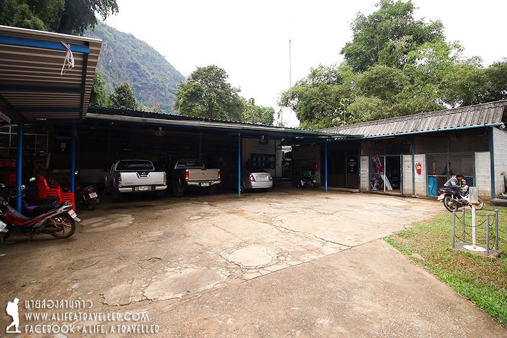
- You can drive your own car to Ban Tha Song Yang and park it at the TAO office or the police station.
- For Mon Kluy tourism, you can use your own car because the road goes up to the top, but it is only recommended for pickup trucks.
- The Mae Sot-Mae Sariang shared taxi will take you to the TAO office for 120 baht per person (information from inquiries, apologies if incorrect). If you rent a car from Mae Sot, it will cost 1,800 – 2,000 baht.
Expenses with the TAO
- Fee per group of 4-6 people 200 baht
(Price depends on the number of people, please check with the Tambon Administrative Organization.)
- Pickup truck fee for pick-up and drop-off is 1,800 baht per vehicle.
(Maximum 9 people per trip, including porters)
- Porter fee for 3 days 2 nights trip is 1,000 Baht per person
Estimated travel time from Mon Tu Lay to Kluay Luang
Day 1
5:30 AM Arrive at Mae Sot Bus Terminal
6:00 AM Take a shared taxi from Mae Sot to Mae Sariang, heading to Tha Song Yang Subdistrict Administrative Organization
9:30 AM Arrive at Tha Song Yang Subdistrict Administrative Organization, prepare for the hike
10:30 AM Depart for Ban Mae Jwang, begin the ascent to Mon Thu Lay
4:00 PM Arrive at the campsite
Day Two
11:00 AM Depart from Mon Thu Lay to Khui Luang
3:00 PM Arrive at Khui Luang
Day 3
09:00 AM Depart from Kholuang
12:00 PM Arrive at the designated pick-up point (coordinate time carefully, no phone signal)
01:00 PM Arrive at Tha Song Yang Subdistrict Administrative Organization
03:00 PM Take the last Mae Sariang-Mae Sot shared taxi
Follow my travel adventures on another channel:
http://www.facebook.com/alifeatraveller
นายสองสามก้าว / A Life, A Traveller
Friday, October 4, 2024 3:08 PM