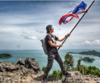


 Our Two Feet are to Conquer Doi Luang Summit & Doi Nok Summit! Episode 2 (the End): Hike up to the Sky and Conquer Doi Nok Summit From previous episode >> Conquer Doi Luang Summit & Doi Nok Summit! Episode 1 It was a 9 km walk and took us 7 and a half hours to take our two feet to stand on the Doi Luang Phayao, the highest point of Doi Luang National Park. We reached there just in time for the last light of the day. Now the sky is turning dark. Stars on the ground are glittering. Below is Ban Pong Tam, Wang Nua District, Lampang Province.  When looking at the East side, the Kwan Phayao from the high angle is lighten up under the bright moon and sparkling with thousands of stars on earth which is much more than the Pong Tam side. That's right, we are looking at Muang District, Phayao Province side. If we were coming a day earlier, we would see the lanterns are floating in the sky and the Kratong are swimming in the lake as yesterday was the twelfth full moon or Loy Kratong Festival. The sky is about to be completely dark. Our head lamp is ready to walk a bit down. Actually, we can also camp up here but it was occupied already. So we 5 people decided to walk down a bit and to actually feel the cold breeze. I'm not sure how camping on top looks like, but camping here with the lake view is awesome!  Good morning to our second day. The weather is a bit cold and the wind freezes us. Anyhow, I come out from the tent to wait for the sun to rise.  I'm sitting near the fire and zipping the warm coffee, soon, the sun is shining over the sky from the southwest, the location of it in the winter. The sun is risen around 6.30 a.m. and gets slower until the end of January when it will rise at 7.00 a.m. Then, it starts to get sooner. If you wish to see it comes up from the middle of the lake, you'll have to come in the mid April. Well, that time is actually hot here at Doi Luang so I'm not sure if it'd be this awesome.  We enjoy the sunrise as well as deeply appreciate the mother nature before packing and continue our journey.  Now, the fog is covering the entire mountain. If looking from below, we would see Doi Luang hidden under the clouds just like the first day when we arrived.  Well, sometimes it's difficult to capture the moments when the fog is moving so the video helps. Please see the atmosphere of the fog floating through the grass on Doi Luang this morning here: https://www.youtube.com/watch?v=b6BD6DAd6bw The weather is warming up now. Let's take off the winter jacket and put on the wind-proof jacket instead.  The wind-proof jacket equinox model windbreak is given by the Outer Innovation sponsor. I'm not sure of the price, you can check it out here: เอาท์ดอร์อินโนเวนชั่น It's very thin and tiny. See when we wrap it up, it's only in a tennis ball size. I'd definitely get it even if I wasn't given one. It's a must have item that I bring with me in every trip, just love it! The wind-proof jacket equinox model windbreak is given by the Outer Innovation sponsor. I'm not sure of the price, you can check it out here: เอาท์ดอร์อินโนเวนชั่น It's very thin and tiny. See when we wrap it up, it's only in a tennis ball size. I'd definitely get it even if I wasn't given one. It's a must have item that I bring with me in every trip, just love it! Ok, after packing the tent, it's time to continue our journey. Our mission for today is to conquer Doi Nok Summit, the highlight of this trip. Our destination is to move our camp to Phrachao Tanjai, which is only 2 km away. Wow, it's so close. I'm never walked this close before, hehe.  The weather is just right as well as the surrounding atmosphere. The walking trail is also great. We just keep walking down and if it's too steep then we just need to walk more carefully.  Somehow, we also need to walk up a bit but most of it is a walking down path. We go from 16xx m towards 14xx m within 2 km distance.  The forest now is very beautiful, especially when it's covered with thick fog. So here I put it in a clip for you: https://www.youtube.com/watch?v=fbgJ0g_fPLA Here is the map indicating its height. I zoom in the trail from Doi Luang to Doi Nok and towards Phrachao Tanjai Statue which is our camping area tonight. The blue line is our walking trail along the ridge.  Doi Nok, The highlight of this trip is fully visible to us again. In fact, we should have seen it from the top of Doi Luang but due to the weather is close so we missed. Looking from here, I'm not sure how we are going to make it. It must be the way....and definitely not the one I see now.  Now we are getting closer to Doi Nok. It is outstandingly stood like a giant rock wall when we look up to it. It'd be a climbing rock class if we have to go up from here.  Well, it's good that we could at least jump with keen shoes. Once we move upwards Doi Nok, we see more rocks and sometimes jumping between them is easier than climbing up and down. Well, it's good that we could at least jump with keen shoes. Once we move upwards Doi Nok, we see more rocks and sometimes jumping between them is easier than climbing up and down. The Cycads (in Thai word, it literally means give up) Shall we give up or move further? We could leave our backpack and take a rest here. This area is very close to Doi Nok already. It's very close to where we need to start climbing up. We can either climb up to Doi Nok first before going to camping area or moving to camping area first and come back to climb in the afternoon. The resting area at the cycads can be a place to weight whether to give up as some people have attitude sickness and they might just go straight to camping area.  This is the satellite map from Doi Luang to Doi Nok and our camping area at Phrachao Tanjai Statue.  Phrachao Tanjai Statue This is from about 260 m away where we are about to climb up to Doi Nok.  Start to hike up to the sky To conquer Doi Nok That we are here, we must climb up. It's quite scary for those who are afraid of the height. But if you do not have this phobia, I think it's alright to climb for you are safe for as long as you don't jump into the air. In that case, we can go pay respect to the Buddha image there.  And this is the scariest it could get. I just photograph it to make it look very scary. Actually when it comes to scary part, there's a link for us to hold onto and the path is not slippery including the rocks and the grass. Besides, we can firmly put our feet onto those rocks. It's also alright to only look up without looking down.  It's actually scary both left and right. Looking back is the least scared one. We now can see how far we have climbed up and Phrachao Tanjai which was just 200 m away has now became so small in a far distance.  Now, let me proudly standing at the Doi Nok Summit which is 1,428 m above the sea level. Yay, we finally made it to the 200 m of hiking up to the sky route. The small Chedi is outstandingly stood here. It is the sign of people's faith who came with determination and carried bricks, sands, water to hike up the sky and built the Chedi here. It is a well sacred and respected Chedi for Phayao and Lampang people as well as other people nearby.  What should we call these? Probably we can call them Guardian Angles! They were engraved on both side of this tiny Chedi. When looking inside, we would see the golden attitude of subduing Mara which looks like Phra Buddha Chinnarat at Phitsanulok outstandingly stand in the middle of the Chedi.   Kirin was craved at the foot of the Chedi.  Katyayana Buddha is located in another corner next to the Kirin which is a small Sala in Doi Nok Summit. It's quite small up here and if the sky is open we would see the 3660 degree view from here.  When looking back to Doi Luang Summit under the clouds from the morning, it starts to be visible to us. I stop and just watch the clouds flowing over the summit from Phayao side towards Lampang side. It's indeed an enjoyable time.  The Foggy Forest  It's time to go down from the sky and Doi Nok. Then, the exciting moment comes again for those who are scared of height. Although you can make it up here by not looking down, you can't do so when going down. It's time to win yourselves even though you are trembling.....cheers!  Now we are standing at the base of Doi Nok again successfully, yay!! We made it!! It's time to go to the place we plan to camp for our second night. It's only 200 m away and we reach there in no time. Now it's only noon but we finish for the walking trail, it's super short. This is the look back to Doi Nok where people are still climbing down.  I put two red circles to mark people who are going down from Doi Nok. This is another angle looking from our second night camping area.  Our second camping area is at Phrachao Tanjai (quick Buddha). The staff told us that it was named after the facts that this statue was built within one day!!! Unpack the stuff and it's time to relax.  I take off my shoes so that my feet can feel the ground sometimes. Today our walking trail ends at noon. It's such a short walking but long resting trip. Actually, the second night is unnecessary for those who have limited times. After going down from Doi Nok, we can have lunch and go back right away. It could be a nice 2 days and 1 night trip. However, I'd like to have a relax time and enjoy more with nature so I ask to have 3 days and 2 nights trip. I think it's also worthy. The light is so great.  There're a lot of clouds in this trip due to it's the time when the cold air from China is coming. When the cold air meets with the warm weather, this clouds happen. The evening light is now cuddling Doi Nok and I quickly grab my camera to capture this moment.  This is the atmosphere of the camping area near the Buddha image. We are cooking. Actually, if you walk down towards Phayao side or the right hand of the Buddha image, there's a Thai pavilion where tourists can sleep. Anyhow, it's occupied now by the other group of tourists. So we stay near the Buddha image. The 3rd Morning, The Last Day The sun is now behind Doi Luang and Doi Nok and it only appears shortly before disappearing into the clouds again. Then, we have breakfast and get ready to hike down.  This staff takes care of the other group and they are also going down today. He comes to say hi to us. He also gives us what he has in hand. He said it is the Thai-Sakura (Phaya Sue Krong) tree. He has such a cool name-Pratet Thai (or Thailand). He also told us that we can put this tree into rice wine and leave it for a couple of days and it would give us great energy that hiking up and down would be just a piece of cake. This staff takes care of the other group and they are also going down today. He comes to say hi to us. He also gives us what he has in hand. He said it is the Thai-Sakura (Phaya Sue Krong) tree. He has such a cool name-Pratet Thai (or Thailand). He also told us that we can put this tree into rice wine and leave it for a couple of days and it would give us great energy that hiking up and down would be just a piece of cake. Now, I take out my GPS track record and put it on Google Earth. The red line is a walking trail down from Doi Luang along the ridge and hike up to they sky to conquer Doi Nok. Then, from Phrachao Tanjai, we keep walking down and along the mountains.  This is another angle of the map. This path of going down is called Klet Nak Waterfall or Ban Tom Route. It is about 4.5 km from Doi Nok Summit or about 4.2 km from Prachao Tanjai.  Now it's 8 a.m. and it's time to walk down. Let's say farewell to the mountain and walking down along the North.  Looking back again to find the sun is still hidden under the clouds as well as the Doi Nok Summit that has yet visible. Again with this view and see you again! Pha Jang Hang After walking a while, the staff points to another high cliff to us. It's called Pha Jang Hang. It's name after the Japanese hiker who conquer it. It's said that this cliff will be promoted to be a place for hiking in the future.  The walking trail is straight down to the lowest point between the ridge before changing towards the East. Pha Jang Hang is now changed to be on our left hands instead of the front too. This path is suitable for walking down but I see someone is walking up. I have to say that Bak Bok is the best choice for going up because the route I'm walking down now is more tiring and doesn't have any good view along the route.  Pha Nang Jub Along the way down, the creeks are there but we can't see much until we go pass a watery area which is Pha Nang Jub.. It has the water flowing down. We can either take our bottle to get the water or simply kiss the cliff and enjoy the water. By kissing to drink the water has made the name of this Pha Nang Jub (kissing cliff). Well, when it gets too humid, we might find snails too.  Klet Nak Waterfall It is another highlight of this route. When we arrive here, it means we are now half way down of 6 km walking trail. We are now 3 km away of the meeting point where we will be picked up. It's very tiring with this steep route, my legs are trembling, the sweats are all over my body. I can hardly walk to appreciate the waterfall. All I can do is taking the photo from afar. Let's end this trip with another infographic map showing the elevator and distances from the start to stop for this entire trip. The overall distance including up and down from Doi Nok is approximately 15.6 km. Let's just say it's 16 km so it'd be easier to remember. 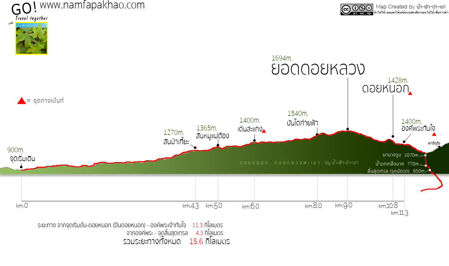 I'd like to say goodbye with this pick up truck photo. It's the end of our walking trail after the mission to conquer Doi Luang and Doi Nok is complete.  Here, I'd like to thank you all the sponsors for this trip: The Tourism Authority of Thailand, Chiang Rai-Phayao Branch, contact number is 053-744674-5. And I also would like to thank other travel sponsors: Nok Air for supporting a round trip ticket of Bangkok-Chiang Rai Avis Thailand for supporting the car of our entire trip Outdoor Innovation for supporting trekking outfit like winter jacket, wind-proof jacket, backpack and a mini tripod Keen Thailand for supporting a trekking shoes, keen newport H2 And finally, I'd like to thank every relevant staff at the Doi Luang National Park. For more information, please visit me at: https://www.facebook.com/Namfapakhao/ |
น้ำ-ฟ้า-ป่า-เขา
Tuesday, November 8, 2016 5:25 PM
Comments