


". . Satun is another interesting southern province with beautiful natural scenery and diverse ways of life. It also boasts a variety of tourist attractions and can be visited all year round. . ."
On April 17, 2018, UNESCO declared "Satun Geopark" as the first Global Geopark in Thailand, which is one of the 3 Global Geoparks in the country.
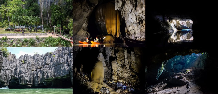
The Satun Geopark area covers the districts of Thung Wa, La-ngu, and Manang, encompassing Tarutao National Park, Mu Ko Phetra National Park, and parts of Khao Banthat Wildlife Sanctuary. The tourist attractions within the Satun Geopark that we visited and will share with you include: Lestegodon Cave, Phu Pha Phet Cave, Thousand Peaks Stone Castle (Khao Yai Island). In addition to these, there are many other tourist attractions in the area.

......................................................................................................................................................................................................
Our first stop upon arriving in Satun...
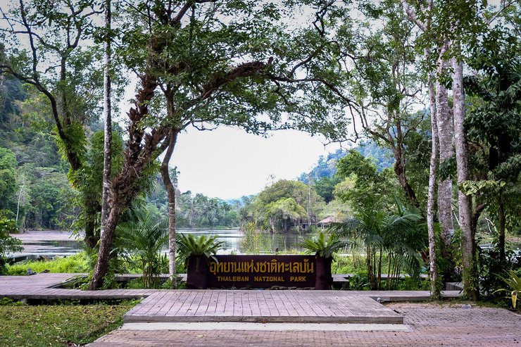
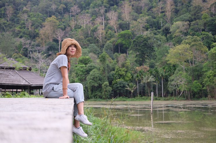
Thale Ban National Park: A Natural Paradise in Satun
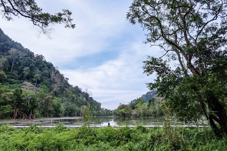
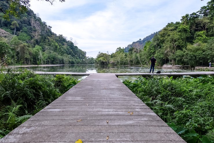
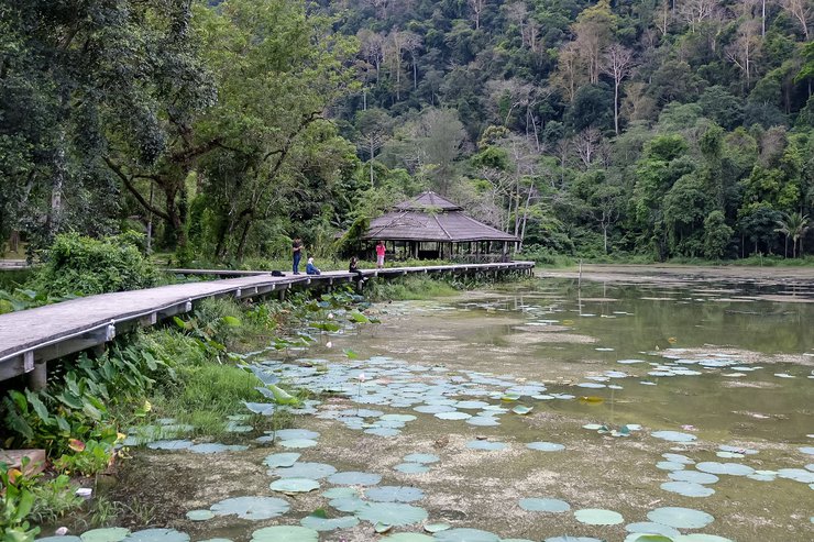
Thale Ban National Park is a haven of natural beauty and biodiversity in Satun Province. Its centerpiece is the Thale Ban freshwater lake, a geological wonder formed by the subsidence of land between the Khao Chin and Khao Wang Pra mountain ranges.
Opening Hours: 8:00 AM - 5:00 PM Contact: 083 533 1710
Getting There:
- From Bangkok, follow Highway 4 (Phetkasem Road) to Surat Thani.
- Continue on Highway 4 (Asian Highway) to Ratthaphum District, Songkhla.
- Turn right onto Highway 406 to Khuan Don District.
- Take Highway 4184 (Thai-Malaysian Border Road) to the junction for Wang Prachan Subdistrict.
- Thale Ban National Park headquarters is a short distance away.

The surrounding area is abundant with trees and various plants, demonstrating the area's rich natural resources. The freshwater lake is home to various fish and other aquatic creatures. The air is cool and refreshing, making it an ideal place to relax and breathe in the fresh air.

The park also features nature trails with sightings of various animals, including wild boars, barking deer, and monkeys. There are long-distance hiking trails and other tourist attractions within the park.


"The octagonal pavilion" is a unique feature of this place, providing a space for relaxation and listening to the sounds of the local inhabitants, who chirp and chatter at intervals. These local inhabitants are the "whistling frogs" or "water dogs" that live with the "bakong trees" around the pond. It is said that anyone who comes here and does not hear the sound of the whistling frogs has not truly arrived at Talay Bua.


The Appearance of the Wawa Frog
The Wawa frog is characterized by its distinctive appearance.
Pahanan Waterfall is located in Thung Nui Subdistrict, Tuan Kalong District, Satun Province. It is situated within the Kua Ka Mining National Reserved Forest and the Ton Nga Chang Wildlife Sanctuary. Pahanan Waterfall is also home to Satun Province's small hydroelectric power plant.
Getting there: Take the Yan Ta Ka Kamthorn Road (Route 42) from Satun towards Hat Yai. Head east from the Ban Thung Nui School (Mittraphap 42) for approximately 7 kilometers. The road is paved throughout. The waterfall is located in Moo 5, Thung Nui Subdistrict, Kuan Kalong District, Satun Province.


This is a popular tourist destination for locals to relax and cool off, as there is a constant flow of water. Visitors can come here year-round and enjoy the natural pools for swimming.


Satun National Museum (Ku Deen Mansion) is located on Satun Thani Road, Soi 5, Piman Subdistrict, Mueang Satun District. The Ku Deen Mansion was built by Phraya Phuminathabhakdi or "Tuan Ku Baharuddin bin Tammangong", the governor of Satun. This building was built to welcome King Chulalongkorn (Rama V) when he visited Satun. However, the king did not stay overnight at this building. Later, it was used for official business and to receive guests visiting Satun. Later, this building became the Satun National Museum, which collects and exhibits the history of the city, as well as the customs, traditions, and way of life of the people of Satun.
The Satun National Museum is open every Wednesday to Sunday from 9:00 AM to 4:00 PM.
Admission fee: Thai citizens 10 baht, foreigners 30 baht.

Model of the Gudehn Mansion

The first floor of the building
will showcase the history of Satun and recreate the lifestyles of its people in the past.


Traditional Pottery Making in Ban Yan Si
This sentence describes the traditional pottery-making process in Ban Yan Si, a village in Thailand.
Here's a breakdown of the translation:
- ปั้นหม้อ-เผาหม้อ: This phrase literally translates to "molding pots - firing pots," which refers to the two main stages of traditional pottery making.
- แบบโบราณ: This means "ancient style" or "traditional style," indicating that the pottery-making process in Ban Yan Si follows methods used for generations.
- บ้านย่านซื่อ: This is the name of the village where the pottery is made.
Therefore, the complete sentence translates to:
Traditional pottery making in Ban Yan Si.

The second floor houses the residence of the Satun city lord and a guest reception room.

The sentence is already in English and does not require translation.
The exhibition also features a model of a traditional house from Satun, complete with bedrooms, kitchens, and various antique household items from the past.


Tan Yong Po Dragon's Spine is located in Tan Yong Po sub-district, Mueang Satun district. In Satun province, there are "Dragon's Spine" or "Sea Parting" up to 7 places, but Tan Yong Po is the largest dragon in Satun. . .
To visit the Dragon's Spine, Tan Yong Po, you have to take a boat to the middle of the sea. You can contact the Bagaan Keuy community, which will have local guides to take you by boat for 2,000 baht. The boat can accommodate about 10 people. The guide will take you to 3 other places: Hin Lek Island, Dragon's Spine, and Black Sand Beach (but we were so engrossed that the sunlight ran out and we missed Black Sand Beach).
Bakkan Community, Tel. 082 434 4295 or 087 477 9793
A 15-20 minute boat ride from the pier will take you to "Iron Rock Island."


The guide led us on a tour of various points on the island, explaining the significance of each location. At one particular spot, the guide informed us that these were footprints from ancient times (possibly giant footprints).

Many areas on the island are covered with rocks that resemble iron in texture. Over time, these rocks have transformed into iron, giving rise to the name "Iron Rock Island."


This area features a rock formation that resembles the Arabic word "Allah."

The rocky island boasts a panoramic viewpoint offering breathtaking 360-degree vistas of the vast azure ocean stretching as far as the eye can see. The refreshing sea breeze adds to the pleasant experience.

The viewpoint is known as "Pha Nang Khoi," which translates to "Cliff of the Waiting Woman." Legend has it that a young woman sat there waiting for her lover to return.


Here, there are also small dragon spines, which are sand dunes that emerge from the sea, or what is called "Talay Waek", but they are small in size, and the water level is currently starting to recede.


A 10-20 minute boat ride from Hin Lek Fai Island will take you to the Dragon's Spine at Tanjung Po.


A long sandbar stretching across the sea, visible during low tide, meanders for approximately 4 kilometers, connecting Koh Huaman and Koh Sam in Tanjung Po. The sandbar is covered with countless tiny shells, which shimmer like dragon scales when illuminated by the setting sun. This resemblance has earned it the name "Dragon's Spine," also known as "Talay Waek" (Split Sea). It is the largest sandbar in Satun Province.


In addition to various shells, we also found the shy "Siamese fireback" on the sand dunes.


We didn't take photos for long at the Dragon's Spine before the sunlight began to change color, turning into the orange hues of dusk. The sun was slowly setting, gradually sinking lower until it finally disappeared into the sea. . .


The next morning, we had an appointment to visit the "Thousand Peaks Stone Castle (Khao Yai Island)".
We contacted the community-based tourism group in Ban Bo Chet Luk for our trip to Khao Yai Island and Prasat Hin Phan Yot. The half-day trip program costs 800 baht per person, while the full-day program costs 1,500 baht per person.
Contact us at 081 542 0071. **Please bring a waterproof bag as you will need to paddle a boat.**
A 30-minute boat ride from the pier reveals another dragon of Satun: a sand dune emerging from the sea. This dune features wave-like patterns on its surface, resembling the scales on a dragon's back. Unlike the sandbar at Tanjung Po, this dune is devoid of seashells.
**At the pier, there are shops selling tea, coffee, toast, deep-fried dough sticks, and rice. These shops are like convenience stores, in case you missed breakfast.**


From the Dragon's Spine, we continued by boat for another 15-20 minutes to Hin Ngam 2 Bay. Here, the guide will let us practice paddling to prepare for paddling through the rock channel to admire the beauty of the Thousand Peaks Stone Castle.


Once you've gotten comfortable with paddling, you're ready to embark on a journey to the Thousand Peaks Stone Castle. Along the way, you'll encounter small islands and some rock crevices. Your guide will paddle alongside you, providing guidance and ensuring you avoid areas with strong currents.


The sentence is already in English and does not require translation.

The sentence is already in English and does not require translation.

The sentence is already in English and does not require translation.


And then we paddled to the entrance of the thousand-pinnacle stone castle. We had to paddle the boat slowly through the stone channel here to enter.

Phra Sat Hin Panyot, located on Ko Khao Yai in Tambon Pak Nam, Amphoe Lang Suan, is under the care of the Mu Ko Phetra National Park.
Visiting the Thousand Peaks Stone Castle requires waiting for the water level to recede, as one must pass through a narrow opening in the rocks to enter. The Thousand Peaks Stone Castle was formed by the erosion of rocks by rainwater, resulting in sharp, oddly shaped, and beautiful stone pillars. Moreover, this area has recently been officially declared a UNESCO Global Geopark due to the discovery of fossils dating back more than 480 million years.


During our visit, the water level was receding, with the seawater reaching approximately waist height. The water continued to recede gradually, revealing the sandy seabed beneath. It was estimated that by around three o'clock in the afternoon, the water would have receded completely, exposing the entire sandy bottom.

The fun is over. . .

The sentence is already in English and does not require translation.
Le-Stegodon Cave: A Treasure Trove of Fossils and a UNESCO Global Geopark
Le-Stegodon Cave, located in Kiriwong Village, Thung Wa Subdistrict, is renowned for its abundance of fossils, particularly those of the Stegodon (ancient mammoth). This discovery led to further exploration, revealing a wealth of other fossil remains, including plant and prehistoric animal fossils. Notably, on April 17, 2018, the area was officially designated as a UNESCO Global Geopark, recognizing its significant geological heritage.
The Tham Lestegodon cave, with a length of approximately 4 kilometers, is renowned as the longest cave in Thailand. The cave features a continuous flow of water that leads to the sea. The cave's entrance connects to a mangrove forest before opening into the sea. The heart-shaped opening of the cave has become a defining feature, inspiring the concept of "finding the heart at the end of the tunnel."
To navigate the Lestegodon Cave by boat, a fee of 300 baht per person is required, with a minimum of 8 people per group. If the group size is less than 8, a flat rate of 2,400 baht will be charged (you can join other groups). **It is highly recommended to bring a waterproof bag.**
Contact: Tung Wua Subdistrict Administrative Organization, Tel. 084 858 5100

To enter the cave, visitors must take a boat ride with a park ranger. Each boat can accommodate two visitors and one ranger, for a total of three people. Boats are equipped with flashlights, life jackets, and helmets for safety during the journey. The boat ride through the cave takes approximately two hours.

The cave's interior is dark, spacious, and remarkably quiet, allowing you to hear your own breath. Notably, the cave has excellent ventilation, eliminating any musty odors. We encountered numerous stalactites and stalagmites of various sizes and unusual shapes hanging from the ceiling or standing perpendicular to the ground. Some resembled animals, depending on individual imagination. The stalactites and stalagmites varied in color, with some being yellow, white, or even shimmering with a diamond-like sheen. Throughout our boat ride, our guide provided insightful explanations about the cave's features.

The sentence is already in English and does not require translation.

The original text is empty. There is nothing to translate.

The sentence is already in English and does not require translation.

"Waterfall Curtain" can be found in many places inside the cave. In this area, there are small cracks in the cave wall that allow water to seep through, eventually forming stalactites that resemble a waterfall flowing out of the wall.


The original text is empty. There is nothing to translate.

The stalactites in this area are slender and closely spaced on the cave ceiling, hanging down in large numbers. They are called "Lan Phirun" or "Coffee Straw Stalactites" and are found in many places within the cave.

The atmosphere inside the cave


As we sailed along, we encountered massive stalactites with a yellow-orange hue. In the heart of the cave, these formations resembled a heart shape.

Before reaching the mouth of the cave (exit), there is a cavity leading upwards, allowing light to shine through. This area is called the "window" of the cave.

The sentence is already in English and does not require translation.

"Squid fossils" were found near the cave exit.

After a two-hour boat ride through the cave, we reached the "Heart at the End of the Tunnel."

The sentence is already in English and does not require translation.

After exiting the cave, we continued our journey by long-tail boat to the pier, where we boarded a car for the return trip. The journey took approximately 30 minutes and offered views of the lush mangrove forests lining both sides of the waterway.

Wang Sai Thong Waterfall is located on Thung Nang Kaeo - Wang Sai Thong Road, Moo 10, Nam Phut Subdistrict, Lang Suan District, approximately 28 kilometers from Kampaeng Phet Municipal District.

The Wang Sai Thong waterfall is a limestone waterfall that can be visited year-round. The waterfall cascades down in tiers, with a sandy and rocky riverbed that prevents slippery moss from forming on the rocks, making it easy and safe to walk across. The surrounding area is filled with large trees that provide shade and a cool atmosphere, making it an ideal place to relax and unwind.
Whitewater rafting services are available at Sai Wang Thong Waterfall. Staff members for whitewater rafting are located on the opposite side of the entrance to Sai Wang Thong Waterfall. Please contact them for inquiries about whitewater rafting.


Phu Pha Phet Cave is located in the Tean Khao Banthat Wildlife Sanctuary, Moo 9, Palm Phatthana Subdistrict, Manang District, Satun Province. It is one of the largest caves in Thailand and is also ranked among the largest in the world (although there is no official confirmation of its exact ranking). Some sources claim it is the largest cave in Thailand and the third largest in the world. The cave covers an area of over 50 rai and is also a geological site that was officially declared a UNESCO Global Geopark on April 17, 2018.
In the past, Phupha Phet Cave served as a shelter for prehistoric humans. Evidence of this includes the discovery of ancient human bones, skull fragments, shards of glazed pottery with rope-patterned designs, and various animal bones. Phupha Phet Cave was discovered by a wandering Buddhist monk named "Luang Ta Plaeng." The cave's original names were "Tham Lod," "Tham Yao," or "Tham Phet," due to its length, winding nature, and the presence of stalactites and stalagmites that shimmered like diamonds when illuminated, hence the name "Tham Phet" (Diamond Cave).
Reaching the cave entrance requires a bit of effort, as visitors must climb over 300 steps, covering a distance of approximately 50 meters. The cave interior is spacious and well-ventilated, but it is relatively dark with limited lighting. Therefore, bringing a flashlight is essential. (Flashlights can be rented for 20 baht before the climb.)
Phu Pha Phet Cave is open daily from 8:30 AM to 3:30 PM. The entrance fee is 30 baht per person.
Entry requires a guide, who will be present at the cave entrance. The entrance fee is 50 baht per person.
The entrance to Tham Phupha Phet Cave is a narrow opening, barely large enough for a person to squeeze through. However, the interior of the cave is surprisingly spacious and expansive.

The cave's interior features a wooden walkway for visitors to explore the stalactites and stalagmites, both living and dead, which vary in size and shape, ranging from small to massive. This area is known as the "Palace Gate Archway."


This area is called "Diamond Curtain Room". It resembles a door arch, and when exposed to light, it sparkles as if covered in diamond dust.

This area is known as the "coral room" or could be seen as resembling "popcorn."


This section resembles a "jellyfish", shimmering with a diamond-like sparkle when exposed to light.

Upon reaching the center of the cave, one encounters a vast chamber dominated by the "Diamond Dome". This dome, distinguished by its soft orange hue, continuously releases water that shimmers when illuminated. This area could be considered the "heart" of the cave.


Next to the Diamond Dome, there is a limestone pillar platform. The shadow on the top resembles "Guanyin."

Atop the Diamond Rock dome, accessible by stairs, one encounters stalactites with a golden hue, resembling long, flowing hair on a woman's head, or perhaps the mane of a "Merlion."


A wooden bridge runs throughout the cave, leading to the Emerald Light clearing. Only a few points along the path are illuminated by lantern light.

As you walk towards the Emerald Light Plaza, an officer shines a light to reveal an image on the top of a rock. The image depicts King Bhumibol Adulyadej (Rama IX) holding a map in his hand.

At the end of the wooden bridge, you will find the "Emerald Light Glade", the highlight of Phupha Phet Cave. This is the only spot inside the cave where sunlight can penetrate through a gap. In the late afternoon, the sunlight hits the Garuda-shaped rock at an angle, creating a beautiful green glow in this area. (This photo was taken around noon, so the light is less intense.)


Beyond the Emerald Light Glade, on the left-hand side, there is a passage leading deeper into the cave. This area is the darkest part of the cave, and the cave walls have raised ridges all around. These ridges were formed by water that was trapped inside the chamber for a long time, causing limestone deposits to accumulate, resembling the back of a naga serpent, hence the name "Naga Chamber."

This is just a glimpse of the many tourist attractions in Satun province. In reality, Satun has a plethora of hidden gems waiting to be discovered. This serves as a testament to the fact that Satun offers much more than just beaches. Contrary to popular belief, Satun is easily accessible and not limited to Koh Lipe. So, don't hesitate to embark on an unforgettable journey to explore the wonders of Satun.
It is crucial to remember that once an area is designated as a "Global Geopark," it becomes a shared responsibility to preserve its natural resources.
. . I hope everyone will work together to protect these natural resources and understand their significance beyond mere "tourism." This responsibility extends beyond local communities or specific groups; it encompasses everyone and every place, not just these special areas. . .^^
dandelion
Wednesday, February 26, 2025 4:52 PM